Albemarle County
 Albemarle County Courthouse |
|
| administration | |
|---|---|
| US state : | Virginia |
| Administrative headquarters : | Charlottesville |
| Address of the administrative headquarters: |
County Courthouse 401 McIntire Road Charlottesville, VA 22902-4579 |
| Foundation : | May 6, 1744 |
| Made up from: |
Goochland County Louisa County |
| Area code : | 001 434 |
| Demographics | |
| Residents : | 98,970 (2010) |
| Population density : | 52.9 inhabitants / km 2 |
| geography | |
| Total area : | 1881 km² |
| Water surface : | 9 km² |
| map | |
| Website : www.albemarle.org | |
Albemarle County is a county in the state of Virginia in the United States . At the 2010 census , the county had 98,970 people and a population density of 52.9 people per square kilometer. The county seat is Charlottesville .
geography
Albemarle County is located in north-central Virginia and has an area of 1,881 square kilometers, including nine square kilometers of water. It is bordered in a clockwise direction by Greene County , Orange County , Louisa County , Fluvanna County , Buckingham County , Nelson County , Augusta County, and Rockingham County .
history
Albemarle County was formed on May 6, 1744 from parts of Goochland County and Louisa County . The area is named after the governor of Virginia Willem van Keppel, 2nd Earl of Albemarle .
Parks and recreation areas
There are nine parks in the county with a variety of sports including baseball, basketball, fishing, boating, tennis, swimming, softball, soccer, and many hiking trails and bike tours. All parks are open all year round.
Demographic data
| Population development | |||
|---|---|---|---|
| Census | Residents | ± in% | |
| 1790 | 12,585 | - | |
| 1800 | 16,439 | 30.6% | |
| 1810 | 18,268 | 11.1% | |
| 1820 | 19,750 | 8.1% | |
| 1830 | 22,618 | 14.5% | |
| 1840 | 22,294 | -1.4% | |
| 1850 | 25,800 | 15.7% | |
| 1860 | 26,625 | 3.2% | |
| 1870 | 27,544 | 3.5% | |
| 1880 | 32,618 | 18.4% | |
| 1890 | 32,379 | -0.7% | |
| 1900 | 28,473 | -12.1% | |
| 1910 | 29,871 | 4.9% | |
| 1920 | 26.005 | -12.9% | |
| 1930 | 26,981 | 3.8% | |
| 1940 | 24,652 | -8.6% | |
| 1950 | 26,662 | 8.2% | |
| 1960 | 30,969 | 16.2% | |
| 1970 | 37,780 | 22% | |
| 1980 | 55,783 | 47.7% | |
| 1990 | 68.040 | 22% | |
| 2000 | 79,236 | 16.5% | |
| 2010 | 98,970 | 24.9% | |
| Before 1900
1900-1990 2000 |
|||
As of the 2000 census , there were 79,236 people in Albemarle County. Of these, 1,535 people lived in collective accommodation, the other residents lived in 31,876 households and 21,070 families. The population density was 42 inhabitants per square kilometer. The racial the population was composed of 85.16 percent white, 9.65 percent African American, 0.17 percent Native American, 2.86 percent Asian, 0.01 percent of residents from the Pacific island area and 0.86 percent from other ethnic groups Groups; 1.29 percent were from two or more races. Hispanic or Latino of any race were 2.56 percent of the population.
Of the 31,876 households, 32.0 percent had children and adolescents under the age of 18 living with them. 54.2 percent were married couples living together, 9.1 percent were single mothers, 33.9 percent were non-families, 27.0 percent were single households and 8.0 percent had people aged 65 years or over. The average household size was 2.44 and the average family size was 2.99 people.
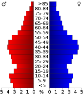
For the entire county, the population was composed of 24.8 percent of residents under 18 years of age, 7.3 percent between 18 and 24 years of age, 30.9 percent between 25 and 44 years of age, 24.5 percent between 45 and 64 years of age 12.5 percent were 65 years of age or over. The median age was 37 years. For every 100 females there were 92.2 males. For every 100 women aged 18 or over there were statistically 88.6 men.
The median income for a household in the city was $ 50,749 , and the median income for a family was $ 63,407. Males had a median income of $ 39,622 versus $ 30,645 for females. The per capita income was $ 28,852. 4.20 percent of families and 6.70 percent of the population lived below the poverty line. This included 6.5 percent of children and adolescents under the age of 18 and 4.7 percent of senior citizens aged 65 and over.
cities and communes
Individual evidence
- ↑ Albemarle County in the United States Geological Survey's Geographic Names Information System . Retrieved February 22, 2011
- ^ US Census Bureau _ Census of Population and Housing . Retrieved February 28, 2011
- ↑ Extract from Census.gov . Retrieved February 28, 2011
- ↑ Extract from factfinder.census.gov ( page no longer available , search in web archives ) Info: The link was automatically marked as defective. Please check the link according to the instructions and then remove this notice. Retrieved February 28, 2011
- ↑ Albemarle County, Virginia ( page no longer available , search in web archives ) Info: The link was automatically marked as broken. Please check the link according to the instructions and then remove this notice. , Datasheet with the results of the 2000 census at factfinder.census.gov .
Web links
Coordinates: 38 ° 2 ′ N , 78 ° 34 ′ W


