
Saint-Symphorien (Gironde)
| Saint-Symphorien | ||
|---|---|---|
.svg)
|
|
|
| region | Nouvelle-Aquitaine | |
| Department | Gironde | |
| Arrondissement | Langon | |
| Canton | Les Landes des Graves | |
| Community association | South Gironde | |
| Coordinates | 44 ° 26 ′ N , 0 ° 29 ′ W | |
| height | 45-86 m | |
| surface | 106.29 km 2 | |
| Residents | 1,837 (January 1, 2017) | |
| Population density | 17 inhabitants / km 2 | |
| Post Code | 33113 | |
| INSEE code | 33484 | |
| Website | http://www.mairie-saint-symphorien-gironde.fr/ | |
 Town hall (Mairie) of Saint-Symphorien |
||

Saint-Symphorien is a French commune with 1,837 inhabitants (at January 1, 2017) in the Gironde department in the region Nouvelle-Aquitaine (before 2016 Aquitaine ). The municipality belongs to the Arrondissement Langon and Les Landes des Graves (until 2015 Saint-Symphorien ). The inhabitants are called Paroupians .
geography
Saint-Symphorien is located about 59 kilometers south-southeast of Bordeaux . Saint-Symphorien is surrounded by the neighboring communities of Louchats and Origne in the north, Balizac in the northeast, Saint-Léger-de-Balson in the east, Bourideys in the south and southeast, Sore in the south, Argelouse in the southwest, Mano in the west and Le Tuzan in the west and northwest.
Population development
| year | 1962 | 1968 | 1975 | 1982 | 1990 | 1999 | 2006 | 2013 |
|---|---|---|---|---|---|---|---|---|
| Residents | 1,537 | 1,385 | 1,385 | 1,414 | 1,396 | 1,398 | 1,527 | 1,806 |
| Source: Cassini and INSEE | ||||||||
Attractions
- Saint-Symphorien church from the 16th century, a historic monument since 1925
- Engine shed, monument historique since 1989
- Barn, monument historique since 2010
- House Siclis, Monument historique since 2007
See also: List of Monuments historiques in Saint-Symphorien (Gironde)

Saint-Symphorien Church

Engine shed
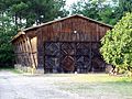
barn

House Siclis


literature
- Le Patrimoine des Communes de la Gironde. Flohic Éditions, Volume 2, Paris 2001, ISBN 2-84234-125-2 , pp. 1152-1153.