
Washington, DC
| Washington, DC | |
|---|---|
 Clockwise from top right: the Capitol , Washington Monument , White House , Smithsonian Institution Building , Lincoln Memorial, and Washington National Cathedral in the evening |
|
 seal |
 flag |
| Location in the United States | |
.svg) |
|
| Basic data | |
| Foundation : | July 16, 1790 |
| State : | United States |
| Federal District : | District of Columbia |
| Coordinates : | 38 ° 54 ′ N , 77 ° 2 ′ W |
| Time zone : | Eastern ( UTC − 5 / −4 ) |
|
Inhabitants : - Metropolitan Area : |
689,545 (as of 2020) 6,385,162 (as of 2020) |
| Population density : | 3,896 inhabitants per km 2 |
| Area : | 177 km 2 (approx. 68 mi²) |
| Height : | 7 m |
| Outline: | 8 boroughs |
| Postcodes : | 20001-20560, 20656-20599, 56901, 56915, 56920, 56944 |
| Area code : | +1 202 |
| FIPS : | 11-50000 |
| GNIS ID : | 531871 |
| Website : | dc.gov |
| Mayor : | Muriel Bowser ( D ) |
The District of Columbia or Washington, DC [ ˈwɔʃɪŋtn̩ ] is the federal district , seat of government and, since 1801, the capital of the United States . The district is not a state and does not belong to any state. Rather, it reports directly to the United States Congress . Despite having the same name as the state of Washington on the west coast of the United States, Washington, DC is usually only called "Washington" in German-speaking countries; DC stands for the District of Columbia .
Washington, DC had a population of 689,545 at the 2020 census . After a steady decline in the population since 1950, this was the first major increase. The Washington metropolitan area had 6,385,162 residents. Together with the neighboring metropolitan area of Baltimore , the region had a total of 9,973,383 inhabitants according to the census.
With the White House as the office and residence of the President and the Capitol , which houses the Congress (consisting of the Senate and House of Representatives ), as well as the Supreme Court , the tips of all three constitutional powers are in the city. Washington is also the seat of the International Monetary Fund , the World Bank and the Organization of American States .
Surname
The official name of the American capital is District of Columbia . Columbia , derived from the name of the navigator Columbus , was a common poetic name for America at the time it was named. The city of Washington is named after George Washington , Commander in Chief in the Revolutionary War and first President of the United States. When the cities of Washington and Georgetown and Washington County were repealed in the District of Columbia Organic Act of 1871, it was determined that the part of the district in which the previous city of Washington was to continue to be referred to as Washington . As pars pro toto , Washington, DC then became the common name for the entire district.
geography
Washington, DC is located near the east coast of the country, about 35 km west of Chesapeake Bay , a bay in the Atlantic Ocean . The city is located at the confluence of the Anacostia River and the Potomac River , on the left bank of the Potomac between the states of Maryland in the northeast and Virginia in the southwest.
City layout
The District of Columbia was formed from land ceded by Maryland and Virginia to remove the federal government and Congress from the control of the then still very powerful individual states and to form a well-planned, modern and representative capital of the new republic.
The original district was 100 square miles (258.9 km²), which is the upper limit prescribed by the United States Constitution . It was a square ten miles (16.1 km) long, the corners of which point exactly in the four cardinal directions.

The area on the western bank of the Potomac, which had originally been ceded by the state of Virginia, was returned to the state in 1846 because the city had grown less rapidly than expected (now Arlington County and partially Alexandria ). This reduced the area to 177 km². Since then, the district has only consisted of areas that originally came from Maryland.
outline

Structure in four quadrants

Division into eight districts ( wards )
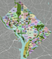
Structure in Area ( neighborhoods )
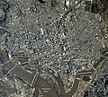
Satellite image March 3, 2021


Washington DC is geographically divided into the four quadrants Northwest (NW), Southwest (SW), Northeast (NE) and Southeast (SE), the boundaries of which meet at the Capitol . Politically, the city is divided into eight districts (wards) , each of which elects its own representatives to the city council.
Most of the streets are straight and numbered. The streets running from east to west are in alphabetical order (see Mannheimer squares ), those in north-south direction are numbered consecutively. The numbering or alphabetization begins in all directions at the Capitol. The large diagonal streets are known as avenues and are mostly named after states.
Cityscape
The most famous buildings are the White House and the Capitol . The equally well-known Pentagon , however, is outside of the city in Arlington . There are no skyscrapers in Washington because no building can be taller than the width of the adjacent street plus 6.1 meters. However, three buildings are not covered by this rule because they were completed, or at least planned, before the law in the early 20th century entered into force: the Washington Monument , the tower of the Old Post Office and the Washington National Cathedral .
climate
Washington is located in the subtropical climate zone with continental influences in winter and, according to Köppen, has a humid - subtropical climate ( effective climate classification : Cfa).
The average annual temperature is 15.2 ° C, the total rainfall is 1,062 mm. The greatest amounts of precipitation are reached in June and July. On average, 40.1 days are hotter than 32 ° C and 60.0 nights are colder than 0 ° C.
| Washington, DC | ||||||||||||||||||||||||||||||||||||||||||||||||
|---|---|---|---|---|---|---|---|---|---|---|---|---|---|---|---|---|---|---|---|---|---|---|---|---|---|---|---|---|---|---|---|---|---|---|---|---|---|---|---|---|---|---|---|---|---|---|---|---|
| Climate diagram | ||||||||||||||||||||||||||||||||||||||||||||||||
| ||||||||||||||||||||||||||||||||||||||||||||||||
|
Climate data Washington DC
Station Washington DC (National Airport) / USA, 4 m above sea level
Source: Water temperature: Wetterkontor, otherwise: NOAA, reference period 1991–2020
|
||||||||||||||||||||||||||||||||||||||||||||||||||||||||||||||||||||||||||||||||||||||||||||||||||||||||||||||||||||||||
| Washington, DC | ||||||||||||||||||||||||||||||||||||||||||||||||
|---|---|---|---|---|---|---|---|---|---|---|---|---|---|---|---|---|---|---|---|---|---|---|---|---|---|---|---|---|---|---|---|---|---|---|---|---|---|---|---|---|---|---|---|---|---|---|---|---|
| Climate diagram | ||||||||||||||||||||||||||||||||||||||||||||||||
| ||||||||||||||||||||||||||||||||||||||||||||||||
|
Climate data Washington DC
Station Washington DC (National Airport) / USA, 4 m above sea level
Source: DWD, reference period: 1961–1990, excluding humidity, reference period: 1942–1995
|
||||||||||||||||||||||||||||||||||||||||||||||||||||||||||||||||||||||||||||||||||||||||||||||||||||||||||||||||||||||||||||||||||||||||||||||||||||||
story
The way to the capital


When the Europeans first arrived in what is now the District of Columbia in the 17th century, it was inhabited by an Indian tribe, the Nacotchtank , who settled on the Anacostia River . In 1749, the city of Alexandria was founded on the Potomac as part of the colony of Virginia , in 1751 a little further north and on the other side of the river, the city of Georgetown, named after King George II , as part of the colony Province of Maryland .
In 1788, James Madison argued in the Federalist Papers (No. 43) that the future federal government must have control of the federal capital. The United States Constitution gave Congress the right to legislate a 10 by 10 mile “district” for the seat of government. The first capital after the ratification of the constitution was New York City (1788–1790). George Washington was the first President of the United States to take the oath of office on the balcony of the Federal Hall there. The Residence Act of 1790 decided to make Philadelphia the capital city for ten years and to look for a permanent place on the Potomac in the meantime. President Washington chose an area that included both parts of Maryland and Virginia. At that time the area consisted primarily of meadow and marshland. It was planned that the congress should meet in the new capital on the first Monday in December 1800. So Washington is a planned capital .
In 1791 the District of Columbia was removed from the states of Maryland and Virginia . It is located on both sides of the Potomac and was originally a square with a side length of exactly 10 miles, or about 16.1 kilometers. The situation came about through a deal between Thomas Jefferson , who came from Virginia, with Alexander Hamilton , whose home in New York City was originally the seat of government: Jefferson supported Hamilton's plans for a national bank, which a capital in the southern states agreed to.

Pierre Charles L'Enfant was commissioned to design the "Federal City". As inspiration, Thomas Jefferson presented him with various city maps that he had brought back from his trip to Europe in 1788, including plans for Frankfurt am Main , Karlsruhe , Amsterdam , Paris , Orléans , Montpellier , Turin and Milan . L'Enfant developed a first version for a city map, but then fell out with the clients from the congress, so that he was recalled from the project. Further planning was then placed in the hands of surveyor Andrew Ellicott , who greatly modified L'Enfant's original plans.
Construction of the new capital began with the future official residence of the US presidents, the White House, on October 13, 1792. A plaque is still there today: “This cornerstone of the house of the President was laid on October 13, 1792 in the 17th year of the independence of the United States of America. President: George Washington, Commissioners: Thomas Johnson, Doctor Stewart , Daniel Carroll, Architect: James Hoban, Builder: Collen Williamson. Vivat Republica "
On June 11, 1800, Washington became the permanent capital of the United States. President John Adams moved his administration to Washington in June 1800. On November 17, 1800, the Congress met for the first time in the new capital.
With the District of Columbia Organic Act of 1801, the District of Columbia came under the direct administration of the Federal Congress . The cities of Alexandria and Georgetown were integrated into the District of Columbia, the area northeast of the Potomac was organized as Washington County , the area southwest of the Potomac as Alexandria County .
19th century


Since elections were then organized by the states, the residents of the District of Columbia had no right to vote. Since most of these were civil servants or government employees, this also corresponded in a certain way to the principle of the separation of powers . However, as the city of Washington grew and its non-government residents increased, this was increasingly seen as an undemocratic anachronism .
On August 24, 1814, during the British-American War , the city was conquered by a 4500-strong British force made up of army and naval units . Among other things, the Capitol was destroyed and the White House was damaged. President James Madison was forced to flee to Virginia with his government. The British Washington campaign from August 19 to 29, 1814 was more of a symbolic character and was intended to make it clear to the Americans not to mess with Great Britain (“Britain is not a country to mess around with”).
Since the 1830s, there have been efforts to reincorporate Virginia, west of the Potomac, Alexandria County. Reasons were the loss of the right to vote due to the special status of the District of Columbia, the economic decline due to the exclusive construction of federal buildings on the Maryland-facing side of the Potomac and the fear that economically important slavery could be banned in the District of Columbia. After the Virginia General Assembly agreed to take back the area in February 1846, Congress decided in July 1846 to hold a referendum on the return. In September 1846, the residents of Alexandria voted 763-222 for the return, the residents of Alexandria County 106-29 against; President James K. Polk then proclaimed the return. Due to reservations that the residents of Alexandria County had not been adequately considered, Virginia did not accept the return until after a long debate on March 13, 1847.
The 1850 Compromise prohibited the slave trade, but not husbandry, from the District of Columbia. During the Civil War from 1861 to 1865, the population rose sharply due to the increased need for federal officials and fled slaves. In 1862, the Compensated Emancipation Act ended slavery through mandatory state ransom, even before the emancipation proclamation the following year.
In the District of Columbia Organic Act of 1871, the cities of Washington and Georgetown and Washington County were repealed and the District of Columbia was placed under unified administration.
20th and 21st centuries


In 1902 a Senate commission presented a master plan for the development of Washington, which became known as the McMillan Plan after chairman of the commission, James McMillan of Michigan . In particular, the previous Victorian parks were replaced by the National Mall in its current form as an open space with flanking public buildings. As part of the New Deal, numerous new buildings were erected or renovated in Washington from the 1930s onwards.
The city has had a city council since 1974 and elects a mayor. However, this parliament has only limited powers. The congress has the possibility at any time to pass resolutions for the capital through this local parliament. He can also dissolve the city council.
The voting rights of Washington citizens are also restricted at the national level. The residents of the District of Columbia have only been allowed to vote for the president since the 23rd Amendment to the Constitution , which came into force in 1961. The number of electors they are entitled to is, however, limited to that of the most populous state. As a result, the District of Columbia has three electors; however, it would not be the case at the moment even without this clause. The district has been represented in the House of Representatives by a non-voting observer since 1970, and not at all in the Senate . This results in the globally unique peculiarity that the residents of the capital of a democratic state are not allowed to vote in their parliament.
In 1978, a constitutional amendment was passed by Congress that would have allowed the citizens of Washington to have the same representation in Congress as if the District of Columbia were a state. Instead of the required three-quarters majority of 38 states, the constitutional amendment was only ratified by 16 states within the seven-year period. In January 2009, a bill for the District of Columbia House Voting Rights Act of 2009 was introduced into Congress, which would make the District of Columbia a constituency for the House of Representatives. However, there is no provision for representation in the Senate. The bill was passed by the Senate with a clear majority, but stalled when Senator John Ensign of Nevada proposed an amendment that would deprive the District of Columbia of the right to restrict gun possession . This addition was also decided. In the House of Representatives, no agreement has yet been reached on how to proceed with the two proposals.
In January 2021, the Washington, DC Admission Act HR 51, a legislative initiative that had already been sanded up in 2020, was reintroduced with the aim of making Washington, DC its own regular state with its own MPs. It is not acceptable that 700,000 residents are not entitled to vote in Congress.
population
.png)
| Census year |
population |
|---|---|
| 1800 | 8,144 |
| 1810 | 15,471 |
| 1820 | 23,336 |
| 1830 | 30,261 |
| 1840 | 33,745 |
| 1850 | 51,687 |
| 1860 | 75,080 |
| 1870 | 131,700 |
| 1880 | 177.624 |
| 1890 | 230.392 |
| 1900 | 278.718 |
| 1910 | 331.069 |
| 1920 | 437,571 |
| 1930 | 486,869 |
| 1940 | 663.091 |
| 1950 | 802.178 |
| 1960 | 763,956 |
| 1970 | 756.510 |
| 1980 | 638.333 |
| 1990 | 606,900 |
| 2000 | 572.059 |
| 2010 | 601.723 |
| 2020 | 689,545 |
ethnicities
In 2015 the population was estimated at 672,228 people, an increase of 11.7% since the last census in 2010. Washington, DC officially had 601,723 inhabitants in 2010 (US Census 2010), of which 50.7% black or African American , 38.5% white, 3.5% Asian, 0.3% indigenous , 0.1% Hawaiian or from other Pacific islands originating. 2.9% belonged to two or more groups. 9.1% of the total population were Hispanics or Latinos of any ethnic group.
religion
The religious communities with the largest number of members in 2000 were the Roman Catholic Church with 160,048, the American Baptist Churches USA with 51,836, the Southern Baptist Convention with 38,852 and the Anglican Episcopal Church with 19,698. 60,479 inhabitants were Islamic and 25,500 Jewish .
education
Of the city's five universities, the most famous are Georgetown University (founded in 1789), George Washington University (founded in 1821), and Howard University (founded in 1867 and one of the oldest universities for the African American population).
politics
Due to its unique status as a federal district, the politics of Washington, DC and the political representation of the residents are distinguished by a few special features:
Urban politics
Washington is directly subordinate to the United States Congress , which has final decision-making power.
From 1802 to 1871 the district had a form of local government in which the administrative structures of Georgetown , a former city on district territory that had become a district, were retained. This gave separate administrations for Georgetown, the city of Washington, the district of Washington and - until the return to Virginia - the city of Arlington. However, certain tasks were taken on jointly, such as B. the administration of the city police founded in 1861. This proved to be inefficient, so that the infrastructure could not keep up with the growing Washington and the standard of living declined.
In 1871, the city government was reformed by the Congress, in which a common government was created for the entire district. This consisted of an eleven-person upper house appointed by the president and a lower house with 22 members elected by the people. There was also a modernization authority. As in states, there was also a governor who was appointed by the president. The extensive modernization measures quickly led to the financial collapse of the city, which is why the popularly elected government was abolished after two governors in 1874.
From 1874 to 1967, the city was run by a three-person committee: two commissioners appointed by the President with Senate approval and an engineer from the United States Army Corps of Engineers . One of the three was appointed chairman and took over the previous role of governor. From 1967 the president appointed a mayor and 9 councilors. Several attempts to introduce a real parliament failed between 1948 and 1968.
It wasn't until 1973 that a law was passed giving the city a mayor and a city council with 13 councilors. The city is divided into 8 electoral districts, each of which elects a city council. The remaining 5 councils are elected by the whole city. There are also advisory neighborhood committees.
All laws passed by the City Council require subsequent approval by Congress. Certain powers are also expressly withdrawn from the city council. So z. B. The jurisdiction of the courts in the district will not be changed. The legal height restriction for buildings in the district must also not be changed.
In 2020, eleven city councilors were Democrats and two were independent. The Republicans have not had a city council since 2009.
congress
The district elects a delegate to the House of Representatives who may vote on committees, but not on general votes. The district has no representation in the Senate.
Presidential election
| year | Democrats | republican |
|---|---|---|
| 2020 | 92.1% 317,323 | 5.4% 18,586 |
| 2016 | 90.9% 282,830 | 4.1% 12,723 |
| 2012 | 90.9% 267,070 | 7.3% 21,381 |
| 2008 | 92.5% 245,800 | 6.5% 17,367 |
| 2004 | 89.0% 202,970 | 9.3% 21,256 |
| 2000 | 85.2% 171,923 | 9.0% 18,073 |
| 1996 | 85.2% 158,220 | 9.3% 17,339 |
| 1992 | 84.6% 192,619 | 9.1% 20,698 |
| 1988 | 82.6% 159,407 | 14.3% 27,590 |
| 1984 | 85.4% 180,408 | 13.7% 29,009 |
| 1980 | 74.9% 130,231 | 13.4% 26,218 |
| 1976 | 81.6% 137,818 | 16.5% 27,873 |
| 1972 | 78.1% 127,627 | 21.6% 35,226 |
| 1968 | 81.8% 139,566 | 18.2% 31,012 |
| 1964 | 85.5% 169,796 | 14.5% 28,801 |
The residents of Washington have been able to vote in the elections for president (and thus also for vice president ) since 1964 . The number of electors to be determined is calculated based on the population as if the district were a federal state. However, under no circumstances may it have more delegates than the smallest state. With the current population size, the city would not be entitled to any more, even without this restriction.
In the event that the electoral college cannot achieve a majority for a candidate in the election of the president or vice-president, the capital loses its right to vote again, since in this case the House of Representatives or the Senate conduct the election in which the district does not ( has voting rights) representation.
Washington DC is considered a stronghold of the Democratic Party . Since 1964, the majority of the electorate has always voted for the Democratic presidential candidate with a margin of at least 56 percentage points. Richard Nixon achieved the highest result of a Republican presidential candidate in Washington DC in the 1972 election with 21.56 percent. In the 2008 election , Barack Obama received 94 percent of the votes cast. The mayoral elections are usually similar.
Status reform proposals

With the exception of voting in presidential elections, Washington residents have no guaranteed voting rights and are severely restricted when compared to residents of the 50 states. This has been criticized again and again, especially by residents and local politicians in Washington. The slogan Taxation without representation was used on Washington's license plates for this purpose . This is based on the slogan No taxation without representation from the American independence movement, which denounced the lack of political representation of the British colonies in North America, although they also paid taxes. Similarly, Washington is hereby advising that residents of Washington pay federal taxes without having any political representation in the federal government.
Therefore, there have always been and still are proposals to eliminate this unequal treatment. One obstacle is that the district is a stronghold of the Democrats , which means that improved voting rights for residents would mean winning votes for that party, which in turn is not in the interests of the other big party, the Republicans .
- By law
A variant that has already been brought into Congress numerous times is the establishment of a representation by law. An attempt to treat the district as a state of the same size failed most recently in 2003, early in the legislative process. Later proposals were limited to establishing representation in the House of Representatives. In some cases, attempts were made to give the state of Utah, a republican stronghold, additional mandates to compensate for shifts in party politics. The last attempt to do this was made in 2009 and failed because of additions that were not acceptable to both chambers of the Congress. In addition, the constitutionality of such an electoral law is controversial.
- Amendment to the Constitution
One constitutionally unquestionable proposal is to pass a constitutional amendment that gives residents of the District of Columbia the right to vote in Congress. This was already successfully done in 1961 with the 23rd Amendment to the Constitution for the right to vote in the presidential election.
A corresponding addition was adopted in 1978 by a large majority by both chambers of the Congress. This provided for the repeal of the 23rd amendment to the constitution and equality of the district in elections to the Congress and presidential elections, in that Washington would have been treated as a state of corresponding size. To take effect, this required the approval of three-quarters of all states, or 38 of 50, within seven years. However, this was clearly missed. By the cut-off date in 1985, only 16 states had consented.
The last such proposal was made in 2009 by Senator Lisa Murkowski .
- Return to Maryland
There is also the idea of making the district part of Maryland again and allowing the residents to vote as citizens of Maryland in elections. The District of Columbia was originally formed from parts of the states of Virginia and Maryland. In 1846 the part taken from Virginia was returned. This could also be done with the land ceded by Maryland, whereby certain areas in the center on which the government buildings stand could be exempted. There are general constitutional concerns that a district is designated as the seat of government in the constitution, so these plans may require a constitutional amendment.
Another variant of this proposal provides for the citizens of Washington to be treated like citizens of Maryland in national elections and, if necessary, to increase the number of MPs in the House of Representatives accordingly. Between 1790 and 1801 this was done exactly so that Congress could decide. A corresponding proposal failed early in the legislative process in 2004.
- Conversion to the state
Another suggestion is to convert the district into a state. Congress has the right to accept new states into the Union. In the 1980s there were two attempts to pass a constitution for a new state "New Columbia". This was also ratified by the residents of Washington. Such plans could not find approval in Congress. Most recently, in 1993, the House of Representatives rejected such a proposal by a clear majority. Last but not least, there are constitutional concerns here as well, since the constitution provides for a district to be the seat of government.
seal
The District of Columbia seal depicts a personification of the goddess Lady Justice , who lays a wreath on a statue of the first US President, George Washington . In the background on the right you can see the Capitol , seat of the legislature of the United States of America. In the background on the left a train drives over a viaduct in front of a rising sun.
The Latin motto is on a banner:
- justitia omnibus
- ("Justice for All")
The year 1871 refers to the year the District of Columbia was established by the District of Columbia Organic Act in its current form.
Town twinning
Washington has fourteen twin cities:
-
 Bangkok , Thailand , since 1962
 -
 Dakar , Senegal , since 1980
 -
 Beijing , People's Republic of China , since 1984
 -
 Brussels , Belgium , since 1985
 -
 Paris , France , since 2000
 -
 Athens , Greece , since 2000
 -
 Pretoria , South Africa , since 2002
 -
 Accra , Ghana , since 2006
 -
 Seoul , South Korea , since 2006
 -
 Sunderland , United Kingdom , since 2006
 -
 Ankara , Turkey , since 2011
 -
 Rome , Italy , since 2011
 -
 Brasília , Brazil , since 2013
 -
 Addis Ababa , Ethiopia , since 2013
Place of protests and major events
The National Mall between the Capitol and the Lincoln Memorial is often used for mass rallies and other major events : the garden and front yard of the White House border the avenue and the Washington Monument offers a good view of the President's residence.
International organizations
Washington is the seat of the Organization of American States (OAS), the World Bank , the International Monetary Fund (IMF) and the US regional office of the World Health Organization (WHO).
business
The gross domestic product per capita in the district was 160,472 US dollars in 2016, which is higher than in any state in the United States. Washington DC owes its prosperity primarily to its status as the administrative and political center of the United States. Major areas of the local economy include tourism, finance, education, health, and research. The state employs a large proportion of Washington DC's workforce. Diplomatic institutions and private foundations also employ large numbers of residents. The unemployment rate was 6.4% in November 2017 (national average: 4.1%). Washington DC was ranked 49th in a ranking of the world's most important financial centers (as of 2018).
Despite the high average income, the city is known for its social problems. In 2013, 18.9% of the population lived in poverty, which is due to the extremely high income inequality. The rate of residents receiving food aid from the state was the highest in the country in the same year. A high crime rate also makes Washington DC one of the most dangerous cities in the United States.
In a ranking of cities according to their quality of life, Washington DC ranked 48th out of 231 cities worldwide in 2018.
traffic
Street
Similar to other US cities, the road system in Washington is built like a chessboard. The city and some suburbs are surrounded by a motorway ring.
rail

The Virginia Avenue Tunnel was completed in 1872.
On November 20, 1990, the last line of the Washington Metro went into operation. The system is the second largest in the United States at 176.32 km. Today the network consists of six lines. There are also a number of bus connections to Maryland, Delaware and Arlington . Washington's mass transit system is operated by the Washington Metropolitan Area Transit Authority .
The originally very extensive tram system was shut down in 1962. A new tram system has existed since February 2016. It currently consists of one line and another is under construction. In the final stage, the tram network could include eight lines. The first section of the H Street / Benning Road Line went into operation ten years later on February 27, 2016 at 10 a.m. local time. The line is a total of 2.4 miles (approximately 3.9 km) long and has 9 stops. The tram takes 20 minutes as planned for this route. According to the schedule, the train runs every 10 to 15 minutes. There is initially no operation on Sundays, but this may be introduced at a later date. Use of the tram is free for a certain period of time.
The route leads east from Washington Union Station along H Street, turns slightly right at the end of this street into Benning Road and ends directly at Langston Golf Course in the immediate vicinity of the Robert F. Kennedy Memorial Stadium . The vehicle fleet consists of three vehicles each from United Streetcar from Portland (Oregon) and Inekon from the Czech Republic . Due to the massive delay in construction, the long test phase and the significantly higher costs, the project often made the headlines. A total of more than $ 200 million was spent on this.
Until September 11, 2001, passengers could get directly from the Pentagon station into the building of the Department of Defense; this exit was closed indefinitely after the terrorist attacks of September 11, 2001 .
air traffic
The closest airport is Ronald Reagan Washington National Airport . Located on the right (west) bank of the Potomac River in Virginia , it is typically only used for domestic air traffic. Washington Dulles International Airport is 45 km west of the city in Virginia and Baltimore-Washington International Airport 65 km northeast in Maryland. Both national and international flights start from the latter two.
Culture
Sports
In the US professional leagues, five teams come from Washington. The Washington Football Team ( NFL ), the Washington Nationals (since 2005) ( MLB ) as well as the Washington Capitals ( NHL ), Washington Wizards ( NBA ) and DC United ( MLS ). This means that Washington is represented in all of the competition classes of the five most popular men's sports in the country.
Attractions

The white house

The Capitol

Blair House , President's Guest House

Cleveland Abbe House , historic building


Monuments and memorials
- Washington Monument
- Jefferson Memorial
- Lincoln Memorial
- Franklin Delano Roosevelt Memorial
- United States Holocaust Memorial Museum
- Second World War Memorial
- Korean War Veterans Memorial
- Vietnam Veterans Memorial
- Memorial to the victims of communism
Churches
- Washington National Cathedral
- Basilica of the National Shrine of the Immaculate Conception (Basilica of the National Shrine of the Immaculate Conception )
- Cathedral of St. Matthew the Apostle
- Holy Trinity Catholic Church

Smithsonian Institution Information Building

_2007.JPG)

Museums
- National Gallery of Art
- Smithsonian Institution , research facility and largest museum complex in the world, including:
- National Museum of Women in the Arts
- Kreeger Museum , private art museum
library
National Archives

Chinatown


Other institutions
Areas
- Federal Triangle
- National Mall
- Chinatown
additional
- Kennedy-Warren Apartment Building (the height of Art Deco in the city)
Personalities
additional
- In the United States, the term DC is short for Washington, DC. "DC" was also the title of a television series by The WB that was set in Washington, DC.
- The term Inside the Beltway refers to Interstate 495 that connects Washington, DC, Alexandria, Virginia, Arlington County, Virginia, Fairfax County (Virginia), Falls Church (Virginia), Montgomery County (Maryland), and Prince George's County ( Maryland) encloses. It stands as a metonym for politicians, lobbyists, high government officials, high media representatives who are interwoven.
literature
- Tom Lewis: Washington: A History of Our National City. Basic Books, New York 2015, ISBN 978-0-465-03921-0 .
- Andreas W. Daum , Christof Mauch : Berlin - Washington, 1800–2000: Capital Cities, Cultural Representation, and National Identities. Cambridge University Press, Cambridge 2011, ISBN 978-1-107-40258-4 .
- David Ovason: Secret Architecture of Our Nation's Capital . Perennial, New York 2002, ISBN 978-0-06-095368-3 .
- Bates Lowry: Architecture of Washington DC Princeton University Press, Princeton 1983, ISBN 978-0-89481-004-6 .
Web links
- Official Website of Washington, DC (English)
- Website of the Tourist Information Office in Washington, DC (English)
- Washington, DC - Resources and Collections in the Library of Congress (English)
Individual evidence
- ↑ United States Census 2020: District of Columbia
- ↑ Quickfacts: District of Columbia
- ^ Metropolitan Statistical Area Washington-Arlington-Alexandria, DC-VA-MD-WV; Census Bureau CBSA Code 47900
- ↑ Washington-Baltimore-Northern Virginia Combined Statistical Area (CSA Code 548)
- ^ The Historical Society of Washington, DC: Questions and Answers on the History of Washington, DC , section How did the city get its name? Quote: "'Columbia', a feminine form of 'Columbus,' was popularized as a name for America in patriotic poetry and song after the Revolutionary War ."
- ↑ a b A Century of Lawmaking for a New Nation: US Congressional Documents and Debates, 1774-1875, Statutes at Large, 41st Congress, 3rd Session, Page 419 of 1314. Library of Congress , accessed on 15 June 2016 (English) .
- ^ National Oceanic and Atmospheric Administration: Summary of Monthly Normals 1991-2020. National Oceanic and Atmospheric Administration, accessed June 18, 2021 .
- ↑ Wetterkontor: Climate Washington DC, USA - climate diagram, climate table - WetterKontor. Wetterkontor, accessed on June 18, 2021 .
- ^ National Oceanic and Atmospheric Administration: NowData - NOAA Online Weather Data. National Oceanic and Atmospheric Administration, accessed June 18, 2021 .
- ↑ German Weather Service: Climate Information Washington DC German Weather Service, accessed on June 18, 2021 .
- ^ "Georgetown Historic District". National Park Service.
- ↑ James Madison , The Same Subject Continued: The Powers Conferred by the Constitution Further Considered. Library of Congress , accessed June 16, 2016 .
- ^ Constitution of the United States. Archive.org, accessed June 16, 2016 .
- ^ Letter from Thomas Jefferson to George Washington dated April 10, 1791. Miles Orvell, Jeffrey L. Meikle (Ed.): Public space and the ideology of place in American culture. Rodopi, Amsterdam and New York 2009, ISBN 978-90-420-2574-5 , footnote on p. 22.
- ↑ Original Plan of Washington, DC In: American Treasures of the Library of Congress. Retrieved June 14, 2013 .
- ↑ a b A Century of Lawmaking for a New Nation: US Congressional Documents and Debates, 1774-1875, Statutes at Large, 6th Congress, 2nd Session, Page 103 of 831. Library of Congress , accessed on 15 June 2016 (English) .
- ^ A b Mark David Richards: The Debates over the Retrocession of the District of Columbia, 1801-2004 . In: www.dcvote.org (Ed.): Washington History . Spring – Summer 2004, pp. 54–82. Retrieved January 16, 2009.
- ^ Horace Greeley: The American Conflict: A History of the Great Rebellion in the United States . G. & CW Sherwood, Chicago 1864, ISBN 0-8371-1438-1 , pp. 142–144 ( preview ).
- ^ Walter Fairleigh Dodd: The government of the District of Columbia ( English ). John Byrne & Co., Washington, DC 1909, pp. 40-5.
- ↑ Sally Kress Tompkins: A Quest for Grandeur: Charles Moore and the Federal Triangle ( English ). Smithsonian Institution Press, Washington, DC 1993, ISBN 978-1-56098-161-9 .
- ^ Mark Gelernter: History of American Architecture . Manchester University Press, 2001, ISBN 978-0-7190-4727-5 , p. 248.
- ↑ By Majid Sattar, A 51st State? , In: FAZ from March 24, 2021
- ↑ a b "QuickFacts District of Columbia" , viewed March 25, 2016.
- ^ The Association of Religion Data Archives | Maps & Reports
- ^ David Leip: Dave Leip's Atlas of US Presidential Elections. Retrieved November 28, 2018 .
- ↑ www.270towin.com
- ↑ DC Sister Cities. dc.gov, accessed June 14, 2013 .
- ^ US Department of Commerce, BEA, Bureau of Economic Analysis: Bureau of Economic Analysis. Retrieved January 8, 2018 (American English).
- ^ Unemployment Rates for States. Retrieved January 8, 2018 .
- ↑ The Global Financial Centers Index 23. (PDF) (No longer available online.) Archived from the original on March 27, 2018 ; accessed on July 13, 2018 .
- ↑ 6 states and DC with the most people in poverty . In: USA TODAY . ( usatoday.com [accessed January 8, 2018]).
- ↑ Mercer's 2018 Quality of Living Rankings. Retrieved July 30, 2018 .
- ↑ http://www.dcstreetcar.com/ (English); accessed on February 27, 2016
- ↑ http://www.nbcwashington.com/traffic/transit/All-Aboard-DC-Streetcar-Service-to-Start-Saturday-370327641.html (English), from February 27, 2016; accessed on February 27, 2016.
- ↑ Want to ride the DC streetcar? Here's a handy FAQ , Washington Post, Feb. 27, 2016; accessed on February 27, 2016. (English)
- ↑ https://www.washingtonpost.com/local/trafficandcommuting/dc-streetcar-makes-its-first-voyages-on-h-street-is-it-really-happening/2016/02/27/bd0c3234-dd5b -11e5-891a-4ed04f4213e8_story.html (English), from February 27, 2016; accessed on February 27, 2016.