
Water (overath)
|
water
City of Overath
Coordinates: 50 ° 55 ′ 48 ″ N , 7 ° 17 ′ 46 ″ E
|
||
|---|---|---|
| Height : | 119 m above sea level NN | |
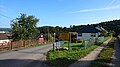
Location of water in Overath |
||
 In the foreground Rittberg , behind it water and on the right the Overather town center
|
||

Wasser is a district of Overath in the Rheinisch-Bergisches Kreis in North Rhine-Westphalia , Germany .
Location and description
Wasser is an elongated, agriculturally used district above the Agger . The best way to get there is via Kreisstraße 34, which is called An der Sonne here . Nearby locations are Aulhof , Schiefenthal , Warth , Rittberg and Lölsberg . From a natural point of view, the extensive wetlands in the area belong to the Agger-Sülz plateaus , which are also home to rare animals and plants.
The Engsiefen brook , a tributary of the Agger, flows around the place.
history
The Topographia Ducatus Montani by Erich Philipp Ploennies , Blatt Amt Steinbach , shows that the residential area had three farms as early as 1715, which are labeled as water . Carl Friedrich von Wiebeking names the courtship on his charter of the Duchy of Berg in 1789 as water . It emerges from it that the place was part of the honor of saints in the parish of Overath at that time .
The place is recorded on the topographical survey of the Rhineland from 1817 as water . The Prussian first recording from 1845 shows the residential area unlabeled. From the Prussian new admission of 1892, the place is regularly recorded as water on measuring table sheets .
In 1822, 22 people lived in the place categorized as a courtyard, which after the collapse of the Napoleonic administration and its replacement belonged to the Overath mayor in the Mülheim am Rhein district . For the year 1830 26 inhabitants are given for the place designated as water . The place, which was categorized as a courtyard in 1845 according to the overview of the government district of Cologne , had five residential buildings with 26 inhabitants at that time, all of them Catholic denominations. The municipal and estate district statistics of the Rhine Province lists water in 1871 with six houses and 32 inhabitants. In the municipality lexicon for the province of Rhineland from 1888, eight houses with 27 inhabitants are given for water . In 1895 the place has seven houses with 31 inhabitants and belonged denominationally to the Catholic parish Marialinden, in 1905 seven houses and 28 inhabitants are given.
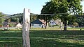
Entrance
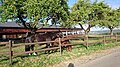
Horse farm
Apple harvest


Individual evidence
- ^ Wilhelm Fabricius : Explanations for the Historical Atlas of the Rhine Province. Second volume: The map from 1789. Division and development of the territories from 1600 to 1794. Bonn 1898.
- ↑ Alexander A. Mützell: New topographical-statistical-geographical dictionary of the Prussian state . tape 5 . Karl August Künnel, Halle 1823.
- ↑ Friedrich von Restorff : Topographical-statistical description of the Royal Prussian Rhine Province , Nicolai, Berlin and Stettin 1830
- ↑ Overview of the components and list of all the localities and individually named properties of the government district of Cologne: by districts, mayor's offices and parishes, with information on the number of people and the residential buildings, as well as the Confessions, Jurisdictions, Military and former state conditions. / ed. from the Royal Government of Cologne [Cologne], [1845]
- ↑ Royal Statistical Bureau Prussia (ed.): The communities and manor districts of the Prussian state and their population . The Rhine Province, No. XI . Berlin 1874.
- ↑ Königliches Statistisches Bureau (Prussia) (Ed.): Community encyclopedia for the Rhineland Province, based on the materials of the census of December 1, 1885 and other official sources, (Community encyclopedia for the Kingdom of Prussia, Volume XII), Berlin 1888.
- ↑ Königliches Statistisches Bureau (Prussia) (Ed.): Community encyclopedia for the Rhineland Province, based on the materials of the census of December 1, 1895 and other official sources, (Community encyclopedia for the Kingdom of Prussia, Volume XII), Berlin 1897.
- ↑ Königliches Statistisches Bureau (Prussia) (Ed.): Community encyclopedia for the Rhineland Province, based on the materials of the census of December 1, 1905 and other official sources, (Community encyclopedia for the Kingdom of Prussia, Volume XII), Berlin 1909.
Web links

Districts of Overath: Overath (core city) | Brombach | Heiligenhaus | Immekeppel | Marialinden | Steinenbrück | Untereschbach | Vilkerath
Districts of the core city: Aulhof | Bernsau | Bedding | Böke | Brambach | Broich | Bridge | Castle | Courtyard | Burgholz | Cyriax | Diepenbroich | Oak trees | Eulenthal | Ferrenberg | Griesenbar | Großbernsau | Gut Eichthal | Gut Ennenbach | Halfensbüchel | Halzemich | Hammer mill | Hasenberg | Höderath | Hooves | Hoof chair | Small bar | Kombach | Kotten | Kotterberg | Stuff | Kreutzhäuschen | Leyenhaus | Lölsberg | Meegen | Mees beam | Probst beam | Rappenhorn | Rittberg | Rottfeld | Schiefenthal | Speak | Vosswinkel | Warth | Water | Weberhöhe | Wolfshütte | Desert height | Wustsiefen
Districts of Brombach: Bilstein | Bökerberg | Brombacherberg | Hagen | Halfenslennefe | Map lennefe | Klefhaus | Klingerath | Oberbrombach | Shrub | Unterilstein | Unterbrombach
Districts of Heiligenhaus: Birken | Burned | Grand Duke | Large Schwamborn | Heather | Kleinschwamborn | Linden tree | Neuenhausen | Steinberg | Stitch | Wiedenhof
Districts of Immekeppel: Brodhausen | Büscherhöfchen | Hasenbüchel | Huferberg | Immekeppelerteich | Kielshöfchen | Leffelsend | Melessen | Mittelsteeg | Obersteeg | Schmitzbüchel | Thal | shore
Districts of Marialinden: Abelsnaaf | Birkenhof | Bixnaaf | Bixnaafermühle | Blindenaaf | Blind eagle mill | Breidenassel | Breitenstein | Büchel | Büscherhöfchen | Buschhoven | Dahl | Flag | Falkemich | Federath | Fisherman's Mill | Großoderscheid | Nicholas pit | Hagen | Hardt | Hentgesnaaf | Height | Kaltenborn | Cherry tree | Kleinoderscheid | Krahwinkel | Staple height | Kulhoven | Landwehr | Linden tree | Lombachsmühle | Lorkenhöhe | Meegen | Niedergrützenbach | Obergrützenbach | Oderscheiderberg | Oderscheiderfeld | Schalken | Schlingenthal | Schlingenthaler Mill | Schommelsnaaf | Threshold baker mill | Siebelsnaaf | Siefen | Tixhoven | Four bridges | Vilshoven | Weyerhof | Weißenstein | Windhausen | Wüststeimel
Districts of Steinenbrück: Altenbrück | Büchel | Bush | Frielinghausen | Großdresbach | Grosshurden | Großlöderich | Heidermühle | Cat me | Klefberg | Kleindresbach | Kleinhurden | Lokenbach | Central cup | Garbage wood | Nallingen | Neichen | Neuhurden | Oberbech | Obergründemme | Schmitzlöderich | Steeg | Stichermühle | Lower plate | Underground me
Districts of Untereschbach: Daubenbüchel | Large book wood | Grünewald | Holzerhof | Mittelauel | Oberauel | Unterauel
Districts of Vilkerath: Aggerhof | Aggermühle | Alemich | Bengelshöhe | Bochmühle | Semolina | Herrenhöhe | Kepplerburg | Klef | Kreutzweg | Krombach | Neuenhaus | Oberhasbach | Oberheide | Obermiebach | Obervilkerath | Rott | Stone house | Unterhasbach | Unterheide | Untermiebach | Untervilkerath