
Cyriax (Overath)
|
Cyriax
City of Overath
Coordinates: 50 ° 55 ′ 23 ″ N , 7 ° 16 ′ 50 ″ E
|
||
|---|---|---|
| Height : | 88 m | |
Location of Cyriax in Overath |
||
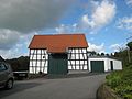
 The old monastery complex today
|
||

Cyriax is a district of Overath in the Rheinisch-Bergisches Kreis in North Rhine-Westphalia , Germany .
Location and description
The district of Cyriax is located south of the Agger . From Overath's center it can be reached via Siegburger Strasse ( Bundesstrasse 484 ) or Propsteistrasse (Kreisstrasse 25) and Pérenchiesstrasse . Cyriax has developed into a school, sports and cultural center. The school center on the outskirts of Cyriax is attended by around 1,600 students from Overath and the surrounding area. It houses the secondary school Overath (under construction) , the Bergische Realschule (in liquidation) and the Paul-Klee-Gymnasium , as well as various sports facilities and the city archive. The center offers space for cultural events and small trade fairs. An ensemble of Bergisch half-timbered houses has been preserved, buildings of the old monastery are used for agriculture or for residential purposes.
history
Cyriax was first mentioned in 1256 as ecclesia s [ancti] . Ciriaci ( Latin : Church of St. Cyriacus) mentioned in a document, 1353 followed by a mention as ad s. Cyriacum (Latin: with St. Cyriacus). The place was named after St. Cyriacus , a saint of consecration that also occurs frequently in the Rhineland .
A chapel of grace consecrated to the saint is said to have stood there, which was heavily visited by processions and individual pilgrims and which was said to have numerous miracles. Therefore, under Abbot Gottfried II , the Siegburg Abbey seemed suitable as a location for a provost's office . The monastery was founded in 1256.
The Topographia Ducatus Montani by Erich Philipp Ploennies , Blatt Amt Steinbach , proves that the place had a chapel , which is labeled as Cyriacy K. Carl Friedrich von Wiebeking names the court on his charter of the Duchy of Berg in 1789 as St. Cyriac Propstey . It emerges from it that the place was part of the honor of saints in the parish of Overath at that time .
The place is recorded on the topographical survey of the Rhineland from 1817 as Ciriax Kp . The Prussian first recording from 1845 shows the residential area under the name Ciriax . From the Prussian new admission in 1892, the place is regularly recorded on table sheets as Ciriax , from the 1950s as Cyriax .
In 1803 the monastery was secularized due to the Reichsdeputationshauptschluss and the monastery buildings were then used for agriculture.
In 1822, 20 people lived in the place categorized as a lease and called Ziriak / Ciriax , which after the collapse of the Napoleonic administration and its replacement belonged to the Overath mayor in the Mülheim am Rhein district . For the year 1830 23 inhabitants are given for the place called Ciriac . The place, which was categorized as a courtyard in 1845 according to the overview of the government district of Cologne , had two residential buildings with 15 inhabitants at that time, all of them Catholic denominations. The municipal and Gutbezirksstatistik the Rhine Province leads Ciriax 1871 with five houses and 40 residents. In the municipality encyclopedia for the province of Rhineland from 1888, five houses with 31 residents are given for Ciriax . In 1895 the place had five houses with 32 inhabitants, in 1905 five houses and 33 inhabitants are given.

Cyriax school center

Half-timbered house Cyriax No. 8
Half-timbered barn

Sandstone wayside cross


.JPG)
Individual evidence
- ^ A b Heinrich Dittmaier : Settlement names and settlement history of the Bergisches Land . In: Journal of the Bergisches Geschichtsverein . tape 74 , parallel edition as a publication by the Institute for Historical Regional Studies of the Rhineland at the University of Bonn. Schmidt, Neustadt ad Aisch 1956.
- ↑ a b Willi Fritzen: The former Propstei St. Cyriax. Retrieved June 19, 2016 .
- ^ Wilhelm Fabricius : Explanations for the Historical Atlas of the Rhine Province ; Second volume: The map of 1789. Division and development of the territories from 1600 to 1794 ; Bonn; 1898
- ↑ Alexander A. Mützell: New topographical-statistical-geographical dictionary of the Prussian state . tape 5 . Karl August Künnel, Halle 1823.
- ↑ Friedrich von Restorff : Topographical-statistical description of the Royal Prussian Rhine Province , Nicolai, Berlin and Stettin 1830
- ↑ Overview of the components and list of all the localities and individually named properties of the government district of Cologne: by districts, mayor's offices and parishes, with information on the number of people and the residential buildings, as well as the Confessions, Jurisdictions, Military and former state conditions. / ed. from the Royal Government of Cologne [Cologne], [1845]
- ↑ Royal Statistical Bureau Prussia (ed.): The communities and manor districts of the Prussian state and their population . The Rhine Province, No. XI . Berlin 1874.
- ↑ Königliches Statistisches Bureau (Prussia) (Ed.): Community encyclopedia for the Rhineland Province, based on the materials of the census of December 1, 1885 and other official sources, (Community encyclopedia for the Kingdom of Prussia, Volume XII), Berlin 1888.
- ↑ Königliches Statistisches Bureau (Prussia) (Ed.): Community encyclopedia for the Rhineland Province, based on the materials of the census of December 1, 1895 and other official sources, (Community encyclopedia for the Kingdom of Prussia, Volume XII), Berlin 1897.
- ↑ Königliches Statistisches Bureau (Prussia) (Ed.): Community encyclopedia for the Rhineland Province, based on the materials of the census of December 1, 1905 and other official sources, (Community encyclopedia for the Kingdom of Prussia, Volume XII), Berlin 1909.
Web links

Districts of Overath: Overath (core city) | Brombach | Heiligenhaus | Immekeppel | Marialinden | Steinenbrück | Untereschbach | Vilkerath
Districts of the core city: Aulhof | Bernsau | Bedding | Böke | Brambach | Broich | Bridge | Castle | Courtyard | Burgholz | Cyriax | Diepenbroich | Oak trees | Eulenthal | Ferrenberg | Griesenbar | Großbernsau | Gut Eichthal | Gut Ennenbach | Halfensbüchel | Halzemich | Hammer mill | Hasenberg | Höderath | Hooves | Hoof chair | Small bar | Kombach | Kotten | Kotterberg | Stuff | Kreutzhäuschen | Leyenhaus | Lölsberg | Meegen | Mees beam | Probst beam | Rappenhorn | Rittberg | Rottfeld | Schiefenthal | Speak | Vosswinkel | Warth | Water | Weberhöhe | Wolfshütte | Desert height | Wustsiefen
Districts of Brombach: Bilstein | Bökerberg | Brombacherberg | Hagen | Halfenslennefe | Map lennefe | Klefhaus | Klingerath | Oberbrombach | Shrub | Unterilstein | Unterbrombach
Districts of Heiligenhaus: Birken | Burned | Grand Duke | Large Schwamborn | Heather | Kleinschwamborn | Linden tree | Neuenhausen | Steinberg | Stitch | Wiedenhof
Districts of Immekeppel: Brodhausen | Büscherhöfchen | Hasenbüchel | Huferberg | Immekeppelerteich | Kielshöfchen | Leffelsend | Melessen | Mittelsteeg | Obersteeg | Schmitzbüchel | Thal | shore
Districts of Marialinden: Abelsnaaf | Birkenhof | Bixnaaf | Bixnaafermühle | Blindenaaf | Blind eagle mill | Breidenassel | Breitenstein | Büchel | Büscherhöfchen | Buschhoven | Dahl | Flag | Falkemich | Federath | Fisherman's Mill | Großoderscheid | Nicholas pit | Hagen | Hardt | Hentgesnaaf | Height | Kaltenborn | Cherry tree | Kleinoderscheid | Krahwinkel | Staple height | Kulhoven | Landwehr | Linden tree | Lombachsmühle | Lorkenhöhe | Meegen | Niedergrützenbach | Obergrützenbach | Oderscheiderberg | Oderscheiderfeld | Schalken | Schlingenthal | Schlingenthaler Mill | Schommelsnaaf | Threshold baker mill | Siebelsnaaf | Siefen | Tixhoven | Four bridges | Vilshoven | Weyerhof | Weißenstein | Windhausen | Wüststeimel
Districts of Steinenbrück: Altenbrück | Büchel | Bush | Frielinghausen | Großdresbach | Grosshurden | Großlöderich | Heidermühle | Cat me | Klefberg | Kleindresbach | Kleinhurden | Lokenbach | Central cup | Garbage wood | Nallingen | Neichen | Neuhurden | Oberbech | Obergründemme | Schmitzlöderich | Steeg | Stichermühle | Lower plate | Underground me
Districts of Untereschbach: Daubenbüchel | Large book wood | Grünewald | Holzerhof | Mittelauel | Oberauel | Unterauel
Districts of Vilkerath: Aggerhof | Aggermühle | Alemich | Bengelshöhe | Bochmühle | Semolina | Herrenhöhe | Kepplerburg | Klef | Kreutzweg | Krombach | Neuenhaus | Oberhasbach | Oberheide | Obermiebach | Obervilkerath | Rott | Stone house | Unterhasbach | Unterheide | Untermiebach | Untervilkerath