Büscherhöfchen (Marialinden)
|
Büscherhofchen
City of Overath
Coordinates: 50 ° 55 ′ 54 ″ N , 7 ° 18 ′ 44 ″ E
|
||
|---|---|---|
| Height : | 221 m above sea level NN | |
|
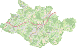
Location of Büscherhöfchen in Overath |
||
Büscherhöfchen is a district of Marialinden in the town of Overath in the Rheinisch-Bergisches Kreis in North Rhine-Westphalia , Germany .
Location and description
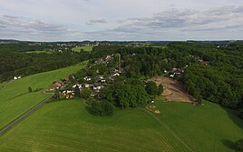
The small district of Büscherhöfchen is located on a hill between the Aggertal and the old pilgrimage site of Marialinden. It can be reached from the center of Marialinden via the Alte Römerstraße in the direction of the castle . At the Büscherhöfchen bus stop, a steep road leads up to the village, which offers a good view of the Bergisches Land. A billboard at the bus stop shows the stations of the old pilgrimage route.
history
The Topographia Ducatus Montani by Erich Philipp Ploennies , Blatt Amt Steinbach , shows that the residential area had a courtyard as early as 1715, which is labeled as a bush . Carl Friedrich von Wiebeking names the court on his charter of the Duchy of Berg in 1789 as Busch . It shows that the place was part of the Honschaft Burg in the parish of Overath at that time . The place was south of the Brüderstraße , an important medieval old highway from Flanders via Cologne to Leipzig .
The place is recorded on the topographical survey of the Rhineland from 1817 as Büscherhöfchen . The Prussian first recording from 1845 shows the residential area under the name Buscherhofchen . From the Prussian new admission in 1892, the place is regularly recorded as Büscherhöfchen on measuring table sheets .
In 1822 four people lived in the place categorized as a (single) house, which after the collapse of the Napoleonic administration and its replacement belonged to the Overath mayor's office in the Mülheim am Rhein district and was called Buscherhof . The place, which was categorized as a courtyard in 1845 according to the overview of the government district of Cologne , had a residential building with ten residents under the name Büscherhof at that time , all of whom were Catholic.
The list of inhabitants and cattle from 1848, according to which taxes were calculated, among other things, has 9 inhabitants in Büscherhöfgen : the family of the farmer Wilhelm Wester with four children. According to the official census, he owned 1 ox and 2 cows. 1 beef, 1 pig .
The municipality and estate district statistics of the Rhine province list Büscherhöfchen 1871 with two houses and 18 inhabitants. In the municipality lexicon for the Rhineland province of 1888, five houses with 21 residents are given for Büscherhöfchen. In 1895 the place has five houses with 23 inhabitants and belonged denominationally to the Catholic parish Marialinden, in 1905 five houses and 22 inhabitants are given.
Individual evidence
- ^ Wilhelm Fabricius : Explanations for the Historical Atlas of the Rhine Province. Second volume: The map from 1789. Division and development of the territories from 1600 to 1794. Bonn 1898.
- ^ Herbert Nicke : The Brothers Street. From the history of the old country road from Cologne to Siegen . In: Land and history between Berg, Wildenburg and South Westphalia . tape 4 . Galunder, Wiehl 2001, p. 70 ff .
- ↑ Alexander A. Mützell: New topographical-statistical-geographical dictionary of the Prussian state . tape 1 . Karl August Künnel, Halle 1821.
- ↑ Overview of the components and list of all the localities and individually named properties of the government district of Cologne: by districts, mayor's offices and parishes, with information on the number of people and the residential buildings, as well as the Confessions, Jurisdictions, Military and former state conditions. / ed. from the Royal Government of Cologne [Cologne], [1845]
- ↑ Berthold Gladbach, Peter Lückerath: The Overather population in name, tax and residents lists from the 15th to the 20th century . Ed .: Geschichtsverein Rhein-Berg, Bergisch Gladbach 2016. ISBN 978-3-932326-75-2 , p. 351
- ↑ Royal Statistical Bureau Prussia (ed.): The communities and manor districts of the Prussian state and their population . The Rhine Province, No. XI . Berlin 1874.
- ↑ Königliches Statistisches Bureau (Prussia) (Ed.): Community encyclopedia for the Rhineland Province, based on the materials of the census of December 1, 1885 and other official sources, (Community encyclopedia for the Kingdom of Prussia, Volume XII), Berlin 1888.
- ↑ Königliches Statistisches Bureau (Prussia) (Ed.): Community encyclopedia for the Rhineland Province, based on the materials of the census of December 1, 1895 and other official sources, (Community encyclopedia for the Kingdom of Prussia, Volume XII), Berlin 1897.
- ↑ Königliches Statistisches Bureau (Prussia) (Ed.): Community encyclopedia for the Rhineland Province, based on the materials of the census of December 1, 1905 and other official sources, (Community encyclopedia for the Kingdom of Prussia, Volume XII), Berlin 1909.


