
Oberhasbach
|
Oberhasbach
City of Overath
Coordinates: 50 ° 58 ′ 22 ″ N , 7 ° 19 ′ 16 ″ E
|
||
|---|---|---|
Location of Oberhasbach in Overath |
||
 Way to Oberhasbach
|
||

Oberhasbach is a district of Vilkerath in the town of Overath in the Rheinisch-Bergisches Kreis in North Rhine-Westphalia , Germany .
Location and description
The small village of Oberhasbach, surrounded by fields and forest, is located above the Agger near the border with the Oberbergischer Kreis . It can be reached via Bundesstraße 55 , which is called Kölner Straße here, and Oberstraße. A hiking trail called the Liederweg leads past the hamlet. Places in the near are Kleuelshöhe Unterhasbach , Obervilkerath , Unterstaat und Oberstaat .
history
Carl Friedrich von Wiebeking names the court on his charter of the Duchy of Berg in 1789 as Ob Hassberg . From it it emerges that the place was part of the Honschaft Vilkerath in the parish Overath at that time .
The place is recorded on the topographical survey of the Rhineland from 1817 as Ob Hasbach . The Prussian first recording from 1845 shows the residential area under the name Oberhasbach . From the Prussian new admission of 1892, the place is regularly recorded on measuring table sheets as Ober Hasbach or Oberhasbach .
In 1822, 19 people lived in the place categorized as Hof and (Ober-) Hasbach , which after the collapse of the Napoleonic administration and its replacement belonged to the Overath mayor in the Mülheim am Rhein district . For the year 1830 19 inhabitants are given for the place called Ober-Hasbach . In 1845, according to the overview of the government district of Cöln, categorized as a farm and designated Ober-Hasbach had six residential buildings with 24 inhabitants, all of them Catholic denominations.
The list of residents and livestock from 1848, which was used, among other things, to collect taxes, counted 25 residents in Oberhasbach, including 14 children under 16 years of age. She gives the names and occupations of the heads of household. Four were farmers : Gerhard Giersiefen ( 2 cows, 1 goat, 2 pigs ), Gerhard Luerz ( 1 cow ). Johann Tix ( 3 cows, 2 pigs ) and Mathias Wiertz ( 1 cow ), ( 1 cattle ), ( 1 pig ). In addition, the authorities included Gundula Müller, who was single and had no cattle.
The municipality and estate district statistics of the Rhine province lists Oberhasbach in 1871 with four houses and 20 residents. In the municipality lexicon for the Rhineland province of 1888, four houses with 16 inhabitants are given for Ober Hasbach . In 1895 the place has three houses with twelve inhabitants and belonged denominationally to the Catholic parish of Hohkeppel, in 1905 three houses and 23 inhabitants are given.
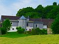
Villa in the hamlet

Forest path

Stream
Song path

.jpg)
.jpg)
.jpg)
Individual evidence
- ^ Wilhelm Fabricius : Explanations for the Historical Atlas of the Rhine Province ; Second volume: The map of 1789. Division and development of the territories from 1600 to 1794 ; Bonn; 1898
- ↑ Alexander A. Mützell: New topographical-statistical-geographical dictionary of the Prussian state . tape 2 . Karl August Künnel, Halle 1821.
- ↑ Friedrich von Restorff : Topographical-statistical description of the Royal Prussian Rhine Province , Nicolai, Berlin and Stettin 1830
- ↑ Overview of the components and list of all the localities and individually named properties of the government district of Cologne: by districts, mayor's offices and parishes, with information on the number of people and the residential buildings, as well as the Confessions, Jurisdictions, Military and former state conditions. / ed. from the Royal Government of Cologne [Cologne], [1845]
- ↑ Royal Statistical Bureau Prussia (ed.): The communities and manor districts of the Prussian state and their population . The Rhine Province, No. XI . Berlin 1874.
- ↑ Königliches Statistisches Bureau (Prussia) (Ed.): Community encyclopedia for the Rhineland Province, based on the materials of the census of December 1, 1885 and other official sources, (Community encyclopedia for the Kingdom of Prussia, Volume XII), Berlin 1888.
- ↑ Königliches Statistisches Bureau (Prussia) (Ed.): Community encyclopedia for the Rhineland Province, based on the materials of the census of December 1, 1895 and other official sources, (Community encyclopedia for the Kingdom of Prussia, Volume XII), Berlin 1897.
- ↑ Royal Statistical Bureau (Prussia) (Ed.): Community encyclopedia for the Rhineland Province, based on the materials of the census of December 1, 1905 and other official sources, (Community encyclopedia for the Kingdom of Prussia, Volume XII), Berlin 1909
Web links

Districts of Overath: Overath (core city) | Brombach | Heiligenhaus | Immekeppel | Marialinden | Steinenbrück | Untereschbach | Vilkerath
Districts of the core city: Aulhof | Bernsau | Bedding | Böke | Brambach | Broich | Bridge | Castle | Courtyard | Burgholz | Cyriax | Diepenbroich | Oak trees | Eulenthal | Ferrenberg | Griesenbar | Großbernsau | Gut Eichthal | Gut Ennenbach | Halfensbüchel | Halzemich | Hammer mill | Hasenberg | Höderath | Hooves | Hoof chair | Small bar | Kombach | Kotten | Kotterberg | Stuff | Kreutzhäuschen | Leyenhaus | Lölsberg | Meegen | Mees beam | Probst beam | Rappenhorn | Rittberg | Rottfeld | Schiefenthal | Speak | Vosswinkel | Warth | Water | Weberhöhe | Wolfshütte | Desert height | Wustsiefen
Districts of Brombach: Bilstein | Bökerberg | Brombacherberg | Hagen | Halfenslennefe | Map lennefe | Klefhaus | Klingerath | Oberbrombach | Shrub | Unterilstein | Unterbrombach
Districts of Heiligenhaus: Birken | Burned | Grand Duke | Large Schwamborn | Heather | Kleinschwamborn | Linden tree | Neuenhausen | Steinberg | Stitch | Wiedenhof
Districts of Immekeppel: Brodhausen | Büscherhöfchen | Hasenbüchel | Huferberg | Immekeppelerteich | Kielshöfchen | Leffelsend | Melessen | Mittelsteeg | Obersteeg | Schmitzbüchel | Thal | shore
Districts of Marialinden: Abelsnaaf | Birkenhof | Bixnaaf | Bixnaafermühle | Blindenaaf | Blind eagle mill | Breidenassel | Breitenstein | Büchel | Büscherhöfchen | Buschhoven | Dahl | Flag | Falkemich | Federath | Fisherman's Mill | Großoderscheid | Nicholas pit | Hagen | Hardt | Hentgesnaaf | Height | Kaltenborn | Cherry tree | Kleinoderscheid | Krahwinkel | Staple height | Kulhoven | Landwehr | Linden tree | Lombachsmühle | Lorkenhöhe | Meegen | Niedergrützenbach | Obergrützenbach | Oderscheiderberg | Oderscheiderfeld | Schalken | Schlingenthal | Schlingenthaler Mill | Schommelsnaaf | Threshold baker mill | Siebelsnaaf | Siefen | Tixhoven | Four bridges | Vilshoven | Weyerhof | Weißenstein | Windhausen | Wüststeimel
Districts of Steinenbrück: Altenbrück | Büchel | Bush | Frielinghausen | Großdresbach | Grosshurden | Großlöderich | Heidermühle | Cat me | Klefberg | Kleindresbach | Kleinhurden | Lokenbach | Central cup | Garbage wood | Nallingen | Neichen | Neuhurden | Oberbech | Obergründemme | Schmitzlöderich | Steeg | Stichermühle | Lower plate | Underground me
Districts of Untereschbach: Daubenbüchel | Large book wood | Grünewald | Holzerhof | Mittelauel | Oberauel | Unterauel
Districts of Vilkerath: Aggerhof | Aggermühle | Alemich | Bengelshöhe | Bochmühle | Semolina | Herrenhöhe | Kepplerburg | Klef | Kreutzweg | Krombach | Neuenhaus | Oberhasbach | Oberheide | Obermiebach | Obervilkerath | Rott | Stone house | Unterhasbach | Unterheide | Untermiebach | Untervilkerath