
Schlingenthal
|
Schlingenthal
City of Overath
Coordinates: 50 ° 57 ′ 3 ″ N , 7 ° 21 ′ 54 ″ E
|
||
|---|---|---|
| Height : | 230 m above sea level NN | |
Location of Schlingenthal in Overath |
||
 Schlingenbach in the Schlingenbachtal nature reserve
|
||

Schlingenthal is a district of Marialinden in the town of Overath in the Rheinisch-Bergisches Kreis in North Rhine-Westphalia , Germany .
Location and description
Schlingenthal is located on the upper part of the approximately six kilometer long Schlingenbach , which rises from a spring and smaller tributaries on the Kleiner Heckberg near Federath and flows into the Agger near Vilkerath . Almost the entire area of the Schlingenbach valley with its special flora and fauna is under nature protection . Schlingenthal can be reached via the narrow district road 37, otherwise largely free of traffic and criss-crossed by hiking trails that also lead to a fishing park. Shortly before Vilkerath, a 280-meter-long A4 motorway bridge spans the area.
history
Schlingenthal was first mentioned in the 13th century as Slingendale , another mention as zor Slindenbach took place in 1550. Mndd. Slingen means squirm , twist , move around meandering . Ahd. slingo is a ablautende addition to the form of shango (= queue ).
The Topographia Ducatus Montani by Erich Philipp Ploennies , Blatt Amt Steinbach , shows that the residential area had two farmsteads as early as 1715, which are labeled as a noose . Carl Friedrich von Wiebeking names the court on his charter of the Duchy of Berg in 1789 as Schlingenthal . It shows that the place was part of the Honschaft Miebach in the parish of Overath at that time .
The place is recorded on the topographical survey of the Rhineland from 1825 as a Schlingleahl . The Prussian first recording from 1845 shows the residential area under the name Schlingenthahl . From the Prussian new admission of 1892, the place is regularly recorded as Schlingenthal on measuring table sheets .
In 1822, 30 people lived in the place, categorized as Hof und Mühle and known as Schlringenahl , which, after the collapse of the Napoleonic administration and its replacement, belonged to the Overath mayor in the Mülheim am Rhein district . For the year 1830 36 inhabitants are given for the place called Schlingenthal . The place categorized as Hof und Mühle in 1845 according to the overview of the government district of Cologne and designated as Schlingenthal had eight residential buildings with 48 inhabitants at that time, all of them Catholic denominations. The municipal and Gutbezirksstatistik the Rhine Province leads sling Thal 1871 with ten houses and 54 residents. In the municipality encyclopedia for the Rhineland province of 1888, nine residential buildings with 41 inhabitants are given for Schlingenthal . In 1895 the place has seven houses with 27 inhabitants and belonged denominationally to the Catholic parish Marialinden, in 1905 seven houses and 46 inhabitants are given.

Schlingenbachthal
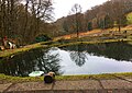
Fishing park

Highway bridge


Individual evidence
- ↑ List of nature reserves in the Rheinisch-Bergisches Kreis
- ^ Heinrich Dittmaier : settlement names and settlement history of the Bergisches Land . In: Journal of the Bergisches Geschichtsverein . tape 74 , parallel edition as a publication by the Institute for Historical Regional Studies of the Rhineland at the University of Bonn. Schmidt, Neustadt ad Aisch 1956.
- ^ Wilhelm Fabricius : Explanations for the Historical Atlas of the Rhine Province ; Second volume: The map of 1789. Division and development of the territories from 1600 to 1794 ; Bonn; 1898
- ↑ Alexander A. Mützell: New topographical-statistical-geographical dictionary of the Prussian state . tape 4 . Karl August Künnel, Halle 1823.
- ↑ Friedrich von Restorff : Topographical-statistical description of the Royal Prussian Rhine Province , Nicolai, Berlin and Stettin 1830
- ↑ Overview of the components and list of all the localities and individually named properties of the government district of Cologne: by districts, mayor's offices and parishes, with information on the number of people and the residential buildings, as well as the Confessions, Jurisdictions, Military and former state conditions. / ed. from the Royal Government of Cologne [Cologne], [1845]
- ↑ Royal Statistical Bureau Prussia (ed.): The communities and manor districts of the Prussian state and their population . The Rhine Province, No. XI . Berlin 1874.
- ↑ Königliches Statistisches Bureau (Prussia) (Ed.): Community encyclopedia for the Rhineland Province, based on the materials of the census of December 1, 1885 and other official sources, (Community encyclopedia for the Kingdom of Prussia, Volume XII), Berlin 1888.
- ↑ Königliches Statistisches Bureau (Prussia) (Ed.): Community encyclopedia for the Rhineland Province, based on the materials of the census of December 1, 1895 and other official sources, (Community encyclopedia for the Kingdom of Prussia, Volume XII), Berlin 1897.
- ↑ Königliches Statistisches Bureau (Prussia) (Ed.): Community encyclopedia for the Rhineland Province, based on the materials of the census of December 1, 1905 and other official sources, (Community encyclopedia for the Kingdom of Prussia, Volume XII), Berlin 1909.
Web links

Districts of Overath: Overath (core city) | Brombach | Heiligenhaus | Immekeppel | Marialinden | Steinenbrück | Untereschbach | Vilkerath
Districts of the core city: Aulhof | Bernsau | Bedding | Böke | Brambach | Broich | Bridge | Castle | Courtyard | Burgholz | Cyriax | Diepenbroich | Oak trees | Eulenthal | Ferrenberg | Griesenbar | Großbernsau | Gut Eichthal | Gut Ennenbach | Halfensbüchel | Halzemich | Hammer mill | Hasenberg | Höderath | Hooves | Hoof chair | Small bar | Kombach | Kotten | Kotterberg | Stuff | Kreutzhäuschen | Leyenhaus | Lölsberg | Meegen | Mees beam | Probst beam | Rappenhorn | Rittberg | Rottfeld | Schiefenthal | Speak | Vosswinkel | Warth | Water | Weberhöhe | Wolfshütte | Desert height | Wustsiefen
Districts of Brombach: Bilstein | Bökerberg | Brombacherberg | Hagen | Halfenslennefe | Map lennefe | Klefhaus | Klingerath | Oberbrombach | Shrub | Unterilstein | Unterbrombach
Districts of Heiligenhaus: Birken | Burned | Grand Duke | Large Schwamborn | Heather | Kleinschwamborn | Linden tree | Neuenhausen | Steinberg | Stitch | Wiedenhof
Districts of Immekeppel: Brodhausen | Büscherhöfchen | Hasenbüchel | Huferberg | Immekeppelerteich | Kielshöfchen | Leffelsend | Melessen | Mittelsteeg | Obersteeg | Schmitzbüchel | Thal | shore
Districts of Marialinden: Abelsnaaf | Birkenhof | Bixnaaf | Bixnaafermühle | Blindenaaf | Blind eagle mill | Breidenassel | Breitenstein | Büchel | Büscherhöfchen | Buschhoven | Dahl | Flag | Falkemich | Federath | Fisherman's Mill | Großoderscheid | Nicholas pit | Hagen | Hardt | Hentgesnaaf | Height | Kaltenborn | Cherry tree | Kleinoderscheid | Krahwinkel | Staple height | Kulhoven | Landwehr | Linden tree | Lombachsmühle | Lorkenhöhe | Meegen | Niedergrützenbach | Obergrützenbach | Oderscheiderberg | Oderscheiderfeld | Schalken | Schlingenthal | Schlingenthaler Mill | Schommelsnaaf | Threshold baker mill | Siebelsnaaf | Siefen | Tixhoven | Four bridges | Vilshoven | Weyerhof | Weißenstein | Windhausen | Wüststeimel
Districts of Steinenbrück: Altenbrück | Büchel | Bush | Frielinghausen | Großdresbach | Grosshurden | Großlöderich | Heidermühle | Cat me | Klefberg | Kleindresbach | Kleinhurden | Lokenbach | Central cup | Garbage wood | Nallingen | Neichen | Neuhurden | Oberbech | Obergründemme | Schmitzlöderich | Steeg | Stichermühle | Lower plate | Underground me
Districts of Untereschbach: Daubenbüchel | Large book wood | Grünewald | Holzerhof | Mittelauel | Oberauel | Unterauel
Districts of Vilkerath: Aggerhof | Aggermühle | Alemich | Bengelshöhe | Bochmühle | Semolina | Herrenhöhe | Kepplerburg | Klef | Kreutzweg | Krombach | Neuenhaus | Oberhasbach | Oberheide | Obermiebach | Obervilkerath | Rott | Stone house | Unterhasbach | Unterheide | Untermiebach | Untervilkerath