Bernsau (Overath)
|
Bernsau
City of Overath
Coordinates: 50 ° 57 ′ 9 ″ N , 7 ° 18 ′ 53 ″ E
|
||
|---|---|---|
| Height : | 180 m above sea level NN | |
|
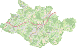
Location of Bernsau in Overath |
||
Bernsau is a district of Overath in the Rheinisch-Bergisches Kreis in North Rhine-Westphalia , Germany .
Location and description
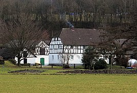
The agricultural district of Bernsau (not to be confused with the Bernsau castle ruins ) is located between the Agger and the A4 . The town center is formed by two spacious properties, including the listed commercial building of the old manor Alt-Bernsau.
The entrance door is adorned with the stone coat of arms of the builder, the Electoral Palatinate Privy Councilor from Codonée. Today the property is privately inhabited and used for agriculture.
history
The place of residence goes back to the Alt-Bernsau castle complex , which was first mentioned in 1218 when a knight von Bernsowe took part in the crusades .
An etymological interpretation of the place name , derived from a legend , is Bären - Au . According to legend, a Countess Berita from Bensberg Castle is said to have had a daughter Jutta, who is said to have been kidnapped by a she-bear. Near the later Bernsau, this is said to have been found undamaged in the Aggeraue next to the she-bear, who was struck by lightning.
The Topographia Ducatus Montani by Erich Philipp Ploennies , Blatt Amt Steinbach , shows that the residential area was named as old Bernzau and called Adelichhaus as early as 1715 . Carl Friedrich von Wiebeking names the court on his charter of the Duchy of Berg in 1789 as Altbernsau . It shows that the place was part of the Honschaft Miebach in the parish of Overath at that time .
The place is recorded on the topographical survey of the Rhineland from 1817 as Bernsau . The Prussian first recording from 1845 shows the living space under the name Bernsaal . From the Prussian new admission in 1892, the place is regularly recorded as Bernsau on measuring table sheets .
In 1822, 15 people lived in the place categorized as a lease and designated as Bernsaul , which after the collapse of the Napoleonic administration and its replacement belonged to the Overath mayor in the Mülheim am Rhein district . For the year 1830, 15 inhabitants are given for the place categorized as leased property and designated as Bernsaul . In 1845, according to the overview of the government district of Cöln, categorized as a manor and designated as Bernsau had two residential buildings with 25 residents, all of them Catholic denominations. The municipal and estate district statistics of the Rhine Province lists Rittergut Bernsau 1871 with two houses and 18 residents. In the municipality encyclopedia for the province of Rhineland from 1888 two houses with 15 inhabitants are given for Bernsau . In 1895 the place has two houses with 20 inhabitants and belonged denominationally to the Catholic parish Marialinden, in 1905 one house and nine inhabitants are given.
After long legal disputes, the manor fell to the Fräuleinstiftung in 1924 , a residence for single, needy noble ladies in Ehreshoven Castle . After the Second World War , the occupying power ordered a land reform to solve social problems such as the refugee crisis . In North Rhine-Westphalia no landowner was allowed to keep more than 100 hectares of his land used for agriculture or horticulture. Among other things, the foundation lost Bernsau, which has been used independently for agriculture ever since.
Individual evidence
- ↑ Jörg Poeffgen (editor): 950 years Overath (1064 - 2014) / Street names tell history. S. 15. Ed. Bergischer Geschichtsverein Overath eV, Overath 2014.
- ↑ a b Willi Fritzen: The former Alt-Bernsau castle, manor of the Knights of Bernsau (12th century). Retrieved September 18, 2016 .
- ^ Wilhelm Fabricius : Explanations for the Historical Atlas of the Rhine Province ; Second volume: The map of 1789. Division and development of the territories from 1600 to 1794 ; Bonn; 1898.
- ↑ Alexander A. Mützell: New topographical-statistical-geographical dictionary of the Prussian state . tape 1 . Karl August Künnel, Halle 1821.
- ↑ Friedrich von Restorff : Topographical-statistical description of the Royal Prussian Rhine Province , Nicolai, Berlin and Stettin 1830.
- ↑ Overview of the components and list of all the localities and individually named properties of the government district of Cologne: by districts, mayor's offices and parishes, with information on the number of people and the residential buildings, as well as the Confessions, Jurisdictions, Military and former state conditions. / ed. from the Royal Government of Cologne [Cologne], [1845]
- ↑ Royal Statistical Bureau Prussia (ed.): The communities and manor districts of the Prussian state and their population . The Rhine Province, No. XI . Berlin 1874.
- ↑ Königliches Statistisches Bureau (Prussia) (Ed.): Community encyclopedia for the Rhineland Province, based on the materials of the census of December 1, 1885 and other official sources, (Community encyclopedia for the Kingdom of Prussia, Volume XII), Berlin 1888.
- ↑ Königliches Statistisches Bureau (Prussia) (Ed.): Community encyclopedia for the Rhineland Province, based on the materials of the census of December 1, 1895 and other official sources, (Community encyclopedia for the Kingdom of Prussia, Volume XII), Berlin 1897.
- ↑ Königliches Statistisches Bureau (Prussia) (Ed.): Community encyclopedia for the Rhineland Province, based on the materials of the census of December 1, 1905 and other official sources, (Community encyclopedia for the Kingdom of Prussia, Volume XII), Berlin 1909.
- ^ Franz Becher: 900 years of Overath. Reprint of the edition from 1964, p. 252. Ed. Bergischer Geschichtsverein Overath eV, Verlag Bücken and Sulzer, Overath 2005, ISBN 3-936405-28-X .


