Unterheide (Overath)
|
Unterheide
City of Overath
Coordinates: 50 ° 58 ′ 3 ″ N , 7 ° 18 ′ 42 ″ E
|
||
|---|---|---|
| Height : | 162 m above sea level NN | |
|
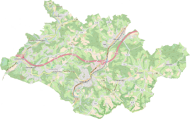
Location of Unterheide in Overath |
||
|
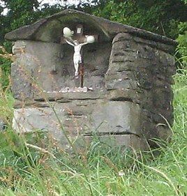
Wayside shrine above the processional path
|
||
Unterheide is a district of Vilkerath in the town of Overath in the Rheinisch-Bergisches Kreis in North Rhine-Westphalia , Germany .
Location and description
The small, agricultural district of Unterheide is located on both sides of Kreisstraße 37 (called Kreuzgarten here), which connects Vilkerath with Hohkeppel. The street is called so because the processional path runs between the cemetery and the church in Vilkerath.
history
Carl Friedrich von Wiebeking names the court on his charter of the Duchy of Berg in 1789 as Nied Heyd . From it it emerges that the place was part of the Honschaft Vilkerath in the parish Overath at that time .
The place is recorded on the topographical survey of the Rhineland from 1817 as Unterheide . The Prussian first recording from 1845 shows the residential area under the name Unterheide . From the Prussian new admission of 1892, the place is regularly recorded as Unterheide on measuring table sheets .
In 1822 15 people lived in the place categorized as a leasehold and designated as Heide , which after the collapse of the Napoleonic administration and its replacement belonged to the Overath mayor in the Mülheim am Rhein district . For the year 1830 25 inhabitants are given for the place called Unter-Heide .
The list of inhabitants and livestock from 1843 lists the seven-member family of the farmer Heinrich Schönborn for Unterheide , to whom 1 ox, 3 cows, 1 cattle and two pigs are assigned - and the five-member family of the farmer Mathias Spiegel, owner of 1 horse, 10 cows , 5 cattle, 4 pigs . Five residents are listed as servants without a name . The place, which was categorized as a courtyard in 1845 according to the overview of the government district of Cologne , had three residential buildings with 20 inhabitants at that time, all of which were Catholic. The municipality and estate district statistics of the Rhine province lists Unterheide in 1871 with four houses and 24 inhabitants. In the municipality lexicon for the Rhineland province of 1888, four houses with 23 inhabitants are given for Unter Heide . In 1895 the place had four houses with 25 inhabitants and belonged denominationally to the Catholic parish of Hohkeppel, in 1905 four houses and 20 inhabitants are given.
Around the beginning of the 19th century there was a so-called winter school in Unterheide . Vilkerath pupils, who normally had to walk to school in Overath, were allowed to attend the winter school in Unterheide, which was set up especially for this purpose, for four to five months because of the poor road conditions at the time.
Individual evidence
- ↑ Jörg Poettgen (editor): Street names tell stories. Bergischer Geschichtsverein Overath e. V. (Ed.), Overath 2014
- ^ Wilhelm Fabricius : Explanations for the Historical Atlas of the Rhine Province ; Second volume: The map of 1789. Division and development of the territories from 1600 to 1794 ; Bonn; 1898
- ↑ Alexander August Mützell, Leopold Krug (Ed.): New topographical-statistical-geographical dictionary of the Prussian state. Second volume. G – Ko. With Karl August Kümmel, Halle 1821 ( digitized ).
- ^ Friedrich von Restorff: Topographical-statistical description of the Royal Prussian Rhine Province . Nicolaische Buchhandlung, Berlin / Stettin 1830 ( digitized ).
- ↑ Berthold Gladbach, Peteer Llückerath: The Overather population in name tax and residents lists from the 15th to the 20th century . Published by Bergischer Geschichtsverein Rhein-Berg, Bergisch sGladbach 2016. ISBN 978-3-932326-75-2
- ↑ Royal Government of Cologne (Ed.): Overview of the constituent parts and list of all the localities and individually named properties of the government district of Cologne, according to districts, mayorships and parishes, with information on the number of people and the residential buildings, as well as the Confessions, Jurisdictions , Military and earlier country conditions. Cologne 1845 ( digitized ).
- ^ The communities and manor districts of the Rhine Province and their population. Edited and compiled by the Royal Statistical Bureau from the original materials of the general census of December 1, 1871. In: Königliches Statistisches Bureau (Hrsg.): The communities and manor districts of the Prussian state and their population. tape XI , 1874, ZDB -ID 1467523-7 ( digitized ).
- ^ Community encyclopedia for the province of Rhineland. Based on materials from the census of December 1, 1885 and other official sources, edited by the Royal Statistical Bureau. In: Royal Statistical Bureau (Hrsg.): Community encyclopedia for the Kingdom of Prussia. tape XII , 1888, ZDB -ID 1046036-6 ( digitized version ).
- ^ Community encyclopedia for the province of Rhineland. Based on materials from the census of December 1, 1895 and other official sources, edited by the Royal Statistical Bureau. In: Royal Statistical Bureau (Hrsg.): Community encyclopedia for the Kingdom of Prussia. tape XII , 1897, ZDB -ID 1046036-6 .
- ^ Community encyclopedia for the Rhine Province. Based on the materials from the census of December 1, 1905 and other official sources, edited by the Royal Prussian State Statistical Office. In: Königliches Prussisches Statistisches Landesamt (Hrsg.): Community encyclopedia for the Kingdom of Prussia. Booklet XII, 1909, ZDB -ID 1046036-6 .
- ↑ Aloys Schwamborn: Development and career of a school / old schools in Vilkerath . In: Achera / Contributions to the history of the city of Overath / Volume 6, p. 77f. Edited by Bergischer Geschichtsverein Overath e. V., Overath 1999. ISSN 0724-1534


