
Charnay (Rhône)
| Charnay | ||
|---|---|---|

|
|
|
| region | Auvergne-Rhône-Alpes | |
| Department | Rhône | |
| Arrondissement | Villefranche-sur-Saône | |
| Canton | Le Bois-d'Oingt | |
| Community association | Beaujolais Pierres Dorées | |
| Coordinates | 45 ° 53 ′ N , 4 ° 40 ′ E | |
| height | 206-446 m | |
| surface | 7.06 km 2 | |
| Residents | 1,057 (January 1, 2017) | |
| Population density | 150 inhabitants / km 2 | |
| Post Code | 69380 | |
| INSEE code | 69047 | |
| Website | http://www.cc-beaujolais.com/charnay/ | |
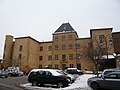
 View of Charnay |
||

Charnay is a commune with 1,057 inhabitants (as of January 1 2017) in the Rhône region of France in the region Auvergne Rhône-Alpes . It belongs to the arrondissement of Villefranche-sur-Saône and the canton of Le Bois-d'Oingt (until 2015: canton Anse ). The inhabitants are called Charnaysiens .
geography
Charnay is located around 19 kilometers north-north-west of Lyon and around eleven kilometers south-south-west of Villefranche-sur-Saône in the Bourgogne wine region . Charnay is surrounded by the neighboring communities of Alix in the north, Marcy in the north-east, Morancé in the east, Saint-Jean-des-Vignes in the south-east, Belmont-d'Azergues in the south, Châtillon in the west and south-west and Bagnols and Frontenas in the north-west.
Population development
| year | 1962 | 1968 | 1975 | 1982 | 1990 | 1999 | 2006 | 2013 |
| Residents | 553 | 515 | 551 | 609 | 775 | 964 | 1,057 | 1,094 |
| Source: Cassini and INSEE | ||||||||
Attractions
- Saint-Christophe Church
- Charnay Castle from the 13th / 14th centuries Century, today's town hall

Saint-Christophe Church
Charnay Castle

