
Geography of Schweinfurt

The geography of Schweinfurt describes the physical nature of the urban area of Schweinfurt and its surroundings as well as the resulting interaction between this habitat and its residents.
physical geography
location
Schweinfurt is almost in the middle of the European Union , the German- speaking area and the DACH region as well as on the 3,500 km long large shipping route that connects the North Sea with the Black Sea via the Rhine-Main-Danube Canal . The city is located about 40 km from Baden-Württemberg , Hesse and Thuringia and can be easily located on the map of Germany, at the beginning of the Main triangle , which is followed by the Mainviereck downstream . Schweinfurt lies in the middle of Main Franconia , which is surrounded by the Rhön , Haßbergen , Steigerwald and Spessart .
The lowest point of the urban area is in the Schweinfurt Basin , on the Main, at 202 m above sea level, the highest at 343 m above sea level in the northeastern Schweinfurt Rhön , the last foothills of which reach close to the eastern old town . Industry and power plants are located exclusively in the south-west of the city, compactly around the main train station and port . The main supply of the industrial city runs over this southwest corridor, with highways, railway lines and high-voltage lines, in the landscape-friendly route bundle.
The city has a central, but outside of this south-western sector towards Werneck and Würzburg also near-natural location. Schweinfurt is immediately or in another environment surrounded by Sennfelder lakes ring , Schweinfurter Rhön with National Heritage Brönnhof and Ellertshäuser See , natural park Haßberge , natural park Steigerwald and Biosphärenreservat Rhön . Schweinfurt Rhön, Steigerwald, Gramschatzer Wald and Rhön are within sight of the city .

Catchment area of the Main,
in the middle of Schweinfurt
Schweinfurt at the Great Water Road,
via the Rhine-Main-Danube Canal North Sea and Black Sea connects
View from the Zabelstein in the Steigerwald
into the Schweinfurt basin


New centrality
As a result of the fall of the Iron Curtain , the changed wirtschaftsgeografische location Schweinfurt fundamentally. The city became a motorway junction in central Germany. In 2005 the Thuringian Forest Autobahn A 71 Erfurt - Schweinfurt was completed as a German Unity Transport Project No. 16 (VDE 16). At around ten million euros per kilometer, it is the most expensive motorway in Germany. The motorways in the Schweinfurt region are almost free of congestion and there were only half as many accidents on their 165 kilometers in 2017 and 2018 as on the only 144 kilometers of the neighboring Würzburg region .
In 2017, Schweinfurt gained further centrality at Deutsche Bahn through the EUR 10 billion German Unity No. 8 (VDE 8) transport project. Berlin can now be reached from Schweinfurt in under three and a half hours, with a change in neighboring Bamberg to the ICE on the new 300 km / h high-speed line . Via the high-speed line leading to the west, with a change in neighboring Würzburg , Munich can be reached in 2:33 hours and Hamburg in 3:57 hours. Berlin and Munich are now about three quarters of an hour faster from Schweinfurt than from Frankfurt a. M. and Paris from 6:22 hours. As part of the DB long-distance traffic offensive, Schweinfurt will receive a direct IC connection by December 2028 at the latest , through the new IC Bamberg - Stuttgart - Tübingen . The renovation of the main train station was completed in 2018 , and of all German cities, Schweinfurt also has the densest network of public transport stops .
Schweinfurt is located on the freight transport route from Nuremberg via the Werntalbahn to the Rhine-Main area in the belt of the New Silk Road .

New centrality in Schweinfurt through reunification and new transport projects
|
Dortmund 350 km |
Kassel 200 km E 10 ° |
Erfurt 160 km |
|
Frankfurt / M 160 km Main N 50 ° Würzburg 45 km |
.svg)
|
Bayreuth 120 km N 50 ° Main Bamberg 55 km |
|
Stuttgart 190 km |
E 10 ° Ulm 230 km |
Nuremberg 120 km |
Berlin (City-West) via A 70: 450 km, via A 71: 442 km
The kilometer data refer to distances between the city centers when driving on motorways
All motorways with the first digit “7” lead in the direction of Schweinfurt (or in the opposite direction), with the exception of the northern part of the A73 . Not far from the city, the 50th degree north latitude (see above: N 50 ° ), which corresponds to the Main line and A 70 , crosses the 10th meridian east longitude ( E 10 ° ), which is identical to the north-south axis of Europe Denmark - Northern Italy and the A 7 is. At the intersection of the two grades, 5.6 km west of the Schweinfurt / Werneck motorway junction , on the B 26a , there is an intersection memorial .
topography
The natural area on the outskirts has diverse characteristics, with different climates, mountainous areas, forests, vineyards, meadows, alluvial forests, protected areas, flowing and standing waters . A large part of the small, political urban area consists of forests (500 ha) and bodies of water (148 ha).

MAIN
View from the Peterstirn
to Böckleinsinsel (right) and boat harbors
MAIN
with Schweinfurt Rhön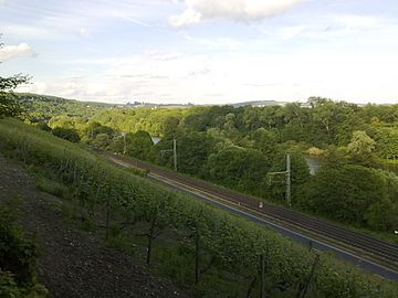
MAINTAL
View from the Schweinfurt vineyards to primeval forest-like forests


.jpg)
Natural structure

|

|
|
|
Schweinfurt Basin
|
Main near Schweinfurt: Schweinfurt basin on the right, Schweinfurt Rhön on the left
|
The majority of the urban area lies within the low relief Schweinfurt basin (main unit 136), which extends heart-shaped on both sides of the Main , with the city center north of the river. The eastern and northern districts of Haardt , Hochfeld and Deutschhof are topographically in part significantly elevated on the southern foothills of the Schweinfurt Rhön landscape north of the Main, which is cut by numerous valleys . It is identical to the natural area Hesselbacher Waldland (main unit 139).
Schweinfurt Basin and Hesselbacher Waldland lie in the core zone of the Main Franconian Plates (main unit group 13). These belong to the south-west German level land on both sides of the Upper Rhine Rift (Greater Region 1st order 07-23), as a continuation of the north French level level land . The layer level land thus extends from the Paris basin to Franconia .
geology
The geology in the urban area ranges (from older / below to younger / above) from the hard limestone and marlstones of the Upper Muschelkalks to the softer clayey - marbled Untereuper (Lettenkeuper), interrupted by individual sandstones and limestone banks, to the soft claystones of the Gipskeuper . In the area between Bergrheinfeld and Schweinfurt there is the center of a tectonic subsidence area (Schweinfurt Mulde ). The plaster keuper came to today's level of the Main, which was able to clear a wide basin in the Quaternary . In the urban area there are sands and gravel as remnants of higher river levels. On the eastern edge of the Main Valley in the urban area there are flying sand dunes at the Schwebheim Forest . They are overgrown with pines and are inactive.
tectonics
The tectonics of the urban area is characterized by the Kissingen - Haßfurt fault zone running northeast of the city center from northwest to southeast , which separates the uplift area of the Kissingen-Haßfurter saddle from the Schweinfurt Mulde. In the area of the saddle zone, hard limestones of the shell limestone were raised to the current level of the Main and its tributaries. The relief is much more mountainous, the rivers could only form narrow valleys.
Hydrology
Due to the topography, there has been no flood within the built-up urban area, except for short-term, small-scale street floods caused by heavy rain . Since the Main at Schweinfurt widens to 172 m, with (former) side arms up to 900 m. In addition, the city center is on a pedestal approx. 10 to 15 m above the water level of the Main.
.jpg)
|

|
|
|
Main flood in January 2011
at the open barrage |
Main ice drift in February 2012
on the Böckleinsinsel |
On the Main itself, however, heavy ice caused great damage to the hydraulic structures during the greatest flood of the 19th century in 1845, with a water level of 6.25 m. During the flood in February 1909, with a water level of 6.10, the ice masses fell over the Main weirs. The Böckleinsinsel and the fortifications (city park) were flooded. A large lake was created between the old town and Sennfeld .
At the city center (about 220 m above sea level. NN) is located on the main Main (Main-km 332) since 1960, a new barrage . Above (east) of it is the Main water level at 207.68 m above sea level. NN. Below the normal Main height is 203.1 m above sea level. NN. In the event of flooding, weirs of the barrage are opened if necessary. The highest level of the Main in the last 100 years above today's barrage was 209.72 m above sea level. NN; Since then, the Main Island was pale grass with a height of 210.0 m above sea level. NN never flooded. In addition, the Saumain is only 203.60 above sea level. NN, where the flood first pours. The lower, southern side of the Main lies in the city area at 205 to 209 m above sea level. NN. The industrial and commercial parks Hafen-Ost , Hafen-West and Maintal , which were built here from 1963 and are almost completely below the barrage, are protected by dikes and have never been flooded (see: Maintal, Hydrology ) until now (2016 ).
climate
Regional climate
A typical feature is the relatively low rainfall , with just over 600 mm per year, due to the city's location east of the Rhön - Spessart ridge . The winters are sometimes very cold, but due to the low altitude by Bavarian standards, the transition times are mild and the summers are warm to hot. While in the higher regions of southern Germany the spring feeding late and as a result of global warming today relatively quickly in the summer passes, the spring pulls in Schweinfurt pool soon and is very pronounced. This leads to the early fruit blossom, diverse flora and good climatic conditions for asparagus and viticulture (see: Viticulture ).
In terms of the degree of continentality , the local climate lies in the transition area between the maritime climate and the continental climate . This already moderate continental climate, in a triad with low precipitation, cold winters and warm summers, does not occur anywhere else in western Germany , but is widespread in eastern Germany . The Schweinfurt and Berlin key climate data are almost identical. The Spessart forms the climatic divide to the maritime climate.
Urban climate
The city has topographical factors that moderate the hot summer , i. Ggs. To the heavily polluted neighboring cities of Würzburg and Kitzingen . Schweinfurt is not in a valley basin , is relatively loosely built and the Main Valley leads i. Ggs. To the aforementioned cities in the main wind direction from east to west. Which means that the winds are not blocked, but favor east wind in high pressure weather conditions and west wind in low pressure . In addition, lakes, floodplains, Schweinfurt Rhön and Schwebheimer Wald border the city and the few vineyards are more natural, instead of the land-adjusted, heat-producing large vineyards around Kitzingen and Würzburg.
Much of the precipitation falls in short thunderstorms in midsummer, the winters are quite dry. In 2015 Schweinfurt became Germany's lightning capital , with 4.5 lightning strikes per square kilometer, the city was ahead of Cottbus (4.3 / km²) and Garmisch-Partenkirchen (4.1 / km²).
additional
Main Islands
.jpg)
The Main Island Bleichrasen (6.93 hectares) is also known as the Main Island as the largest of the three Schweinfurt Main Islands and until the post-war period it was also referred to as Pale Lawn . The island is located at the level of the north Main town of Schweinfurt , between the lock canal to the north and the tributary of the Saumain Main to the south . In 2004 the Maininsel Conference Center (KMI) with a larger four-star hotel was opened on the island .
The Böckleinsinsel (2.70 hectares) was also popularly known as the Pfaueninsel and is located directly to the east of the Maininsel Bleichrasen, between the main arm of the Main in the north and the southern Saumain . The Böckleinsinsel has been family-owned since 1806 and is not accessible to unauthorized persons; there is a flour mill on it
The Schleuseninsel (4.37 hectares) lies between the main arm of the Main in the north and the lock canal in the south. The Schweinfurt run-of-river power plant is located on it, and the monumental anchor sculpture by the Berlin artist couple Brigitte and Martin Matschinsky-Denninghoff is located on the eastern end of the island . Brigitte Matschinsky-Denninghoff was assistant to Henry Moore .
Three-franc look
At the upper end of the Peterstirn vineyard there is a small observation tower. From here you can look over the Mainfränkische Platten to the entire Steigerwald eaves , which in small parts belongs to Upper Franconia . When visibility is good, the Kapellenberg above the wine village of Bullenheim in Middle Franconia can be seen to the west (right) behind the Schwanberg , 48 km away .
Protected areas and cultural landscapes
Protected areas
.jpg)
In the city there is a nature reserve called Saumain in the city of Schweinfurt , two landscape protection areas , two FFH areas (as of March 2016) and a geotope .
See also: List of nature reserves in the city of Schweinfurt , list of landscape protection areas in Schweinfurt , list of FFH areas in the city of Schweinfurt and list of geotopes in Schweinfurt
Viticulture
The local viticulture has only a very low economic, but still cultural significance for the city. It is important for self-awareness and the local way of life. Schweinfurt is now a large linerless wine village in the Franconian wine region , in the area Maindreieck , in the lower part Volkacher Mainschleife , with 3.54 hectares under vine (2017).

Viticulture has been practiced in Schweinfurt for well over 1000 years. At the beginning of the 19th century Schweinfurt was an important Franconian wine-growing and wine trading town. At the end of the imperial city period 1802 there were around 320 hectares of vineyards, which corresponds to the largest Franconian wine-growing town Nordheim am Main today (2017: 319 hectares). Goethe valued the Schweinfurt wine and had large quantities delivered, in 1821 alone it was 700 liters. The connection between Goethe and Schweinfurt wine emerges from seven Goethe letters that are kept in the Goethe-Schiller Museum in Weimar . Large parts of some of today's districts, up to the edge of the old town, are located on former vineyards. In particular the Kiliansberg , which is also indicated by the street names Weingartenweg and Wingertstraße .
.jpg)
The phylloxera appeared in Franconia in 1902. It hit the Schweinfurt area particularly hard and viticulture declined here even more than anywhere else. From 1960 the revival of viticulture began in Franconia, which did not take place in Schweinfurt. Here, only a few part-time and hobby winegrowers on small areas along the Mainleite operated viticulture on the pre-war structures that were largely fallow. Since the 1980s, viticulture has been increasing as planned, here on the eastern edge of the city, in the historic Peterstirn and Mainleite vineyards, with the lead variety Silvaner . Due to the almost complete interruption of viticulture up to the 1980s, the vineyards were spared from being assigned to large vineyards and from the land consolidation in the 1970s, during which the historical structures were mostly destroyed. The small wine and cultural landscape at Peterstirn Palace with its natural stone walls and tool sheds was preserved. There is a family-owned winery on the Peterstirn , where a wine festival takes place twice a year ( see: Regular events ).
Human geography
City structure
An official city structure, with division into districts and districts , such as B. in Bayreuth does not exist. In the absence of this, real estate portals use the city structure from the youth welfare plan of the city of Schweinfurt. The urban area was divided into 14 districts (bold font in list) and 23 statistical districts . The Maintal district is not yet included in the outdated plan and has been added to the list. No suburbs were incorporated during the Bavarian regional reform , which is why the urban area only includes the core town and Oberndorf , which was incorporated in 1919 .

 Old town,
crooked alley
City center, justice district


 North-eastern district,
Kiliansberg Deutschhof,
Kreuzbergstrasse


| No. | district | Inhabitants December 31, 2015 |
Foreigners (%) |
Dual nationals (%) |
|---|---|---|---|---|
| 11 | Old town (to the city center) | 2,529 | 17.7 | 6.9 |
| 12 | Downtown -West | 4,291 | 29.4 | 15.7 |
| 13 | Downtown north | 3,994 | 23.0 | 13.1 |
| 21st | Bergl | 9,162 | 18.8 | 23.9 |
| 22nd | Musicians' quarter | 3,103 | 20.4 | 20.1 |
| 31 | Northwestern part of the city | 3,314 | 19.1 | 15.5 |
| 32 | Garden city | 2,787 | 6.6 | 9.4 |
| 33 | Northern part of the city | 3,024 | 11.9 | 16.6 |
| 34 | Haardt | 1,779 | 7.4 | 17.4 |
| 35 | Donkey height | 2,561 | 4.3 | 13.9 |
| 41 | Hochfeld / Steinberg | 5.126 | 7.6 | 10.8 |
| 42 | Northeastern part of the city | 2,734 | 7.4 | 8.2 |
| 43 | Deutschhof South | 1,855 | 6.1 | 26.3 |
| 44 | Deutschhof-Mitte | 1,454 | 9.6 | 27.4 |
| 45 | Deutschhof-Ost | 962 | 7.3 | 25.7 |
| 46 | Deutschhof-North | 963 | 6.0 | 14.6 |
| 47 | Deutschhof-Zeilbaum | 784 | 1.9 | 11.4 |
| 51 | Hafen-Ost | 244 | 7.8 | 7.4 |
| 52 | Harbor West | 22nd | 50.0 | 4.5 |
| 53 | Swimming lake in the Schwebheim Forest | 4th | 0.0 | 0.0 |
| 54 | Main valley | 2 | 0.0 | 0.0 |
| 61 | Oberndorf South | 1,135 | 11.3 | 9.7 |
| 62 | Oberndorf-Mitte | 1,326 | 16.1 | 13.7 |
| not assignable | 47 | 2.1 | 25.5 | |
| Schweinfurt as a whole | 53.202 | 14.6 | 16.2 |
Within the city districts, there are smaller, not officially established districts, some of which are not identical to the 23 statistical districts.
- Old commercial district (city center)
- Bellevue (musicians' quarter)
- Wide meadow (Hochfeld / Steinberg)
- Carus Park (northwestern part of the city)
- Fischerrain (city center)
- Gründerzeitviertel (city center)
- Hainig (northwestern part of town)
- Höllental (northeastern part of town)
- Kiliansberg (northeastern part of town)
- Klingenbrunn (northern district)
- Blade height (Hochfeld / Steinberg)
- Neutorvorstadt (city center)
- Theuerbrünnleinssiedlung (northern district)
- Yorktown Village (Northwest District)
- Zeilbaum (Deutschhof)
- Zurich (old town)
Cityscape
In almost all national publications it is wrongly stated that Schweinfurt was very badly destroyed in the aerial warfare in World War II , which is not the case. Around 45% of the city was destroyed and therefore just as badly as Rothenburg ob der Tauber, for example . There was no firestorm , in contrast to neighboring Würzburg. After the Second World War, a planned, rapid reconstruction was therefore only necessary in a few places in the city. As a result, there was still scope for design for later times, as the gaps were gradually closed over many stylistic epochs. In the west of the city, the architectural style of the 1930s is still characteristic of the cityscape. In particular, the brick buildings of large-scale industry in the Bauhaus style , in street fronts that have been completely preserved to this day or partially reconstructed after war damage.
The development from a historic small town through industrialization to the regional center for half a million inhabitants is also reflected in the contrasting, tense cityscape. In the inner city, the cityscape gradually becomes more metropolitan from east to west (from left to right in the picture sequence above). Old Franconian alleys in the redeveloped quarters of the eastern old town merge into medium-sized, sometimes chaotic structures around the Roßmarkt , up to the big cityscape in the western city. An exception in the east is the Rückert-Center in the brutalism of the 1970s (nickname Zementrum : originally it had a concrete facade and was called Centrum ).

Rückert Center
and Alte Reichsbank
Market square
with town hall
Scrap tower

Wilhelminian-style district
Schillerplatz
City
with Iduna high-rise


Skyline
Everything towers above the 25-storey blue skyscraper on a foothill of the Schweinfurt Rhön , the top of which (without antennas) is already 130 m above the city center, at 350 m above sea level. NN is located. When it was completed in 1964, the 73 m high-rise building was 5 m higher than the tallest high-rise building in Frankfurt am Main to date , the Zurich House . The first high-rise in the city was built on the Bergl at the end of the 1950s as a residential high-rise with 15 floors and the last high-rise, as in many other places, was built in the 1970s. The renaissance of high-rise construction in the 21st century , with luxury apartments, has not yet reached the city (2019). Since the late 1970s, only industrial high-rise buildings such as power plants and high-bay warehouses have been built . Despite restructuring in the city towards the service sector, the industrial skyline was manifested, which is particularly impressive at night: with the Schweinfurt joint power station (GKS), with its massive 97.5 m high chimney, several high-bay warehouses, grain silos and on the periphery the 2015 decommissioned Grafenrheinfeld nuclear power plant (KKG), with the two 143 m high cooling towers and the 164 m high meteorological mast . Behind the skyline of the industrial plants you can see the surrounding mountain ranges and low mountain ranges.
- The industrial skyline
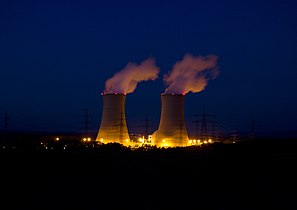
Grafenrheinfeld nuclear power plant
(shut down in 2015)
View of the Rechtsmainische industrial area with
the Gramschatzer forest on the horizon
SKF high-rise

FAG high-rise
Schaeffler AG


See also: retail images
Neighboring communities
Nine communities, all of which belong to the district of Schweinfurt , border the independent city of Schweinfurt.
| Niederwerrn | Dittelbrunn | Uchtelhausen |
| Geldersheim |
|
Sparing |
| Bergrheinfeld | Grafenrheinfeld |
Sennfeld Gochsheim |
Spatial planning

Schweinfurt is a regional center and by far the largest city in the Main-Rhön planning region (No. 3), one of 18 planning regions in Bavaria . It includes the independent city of Schweinfurt and the districts of Schweinfurt , Bad Kissingen , Haßberge and Rhön-Grabfeld . The Regiopole Region Mainfranken was founded on July 23, 2018. In addition to the district-free Schweinfurt and the four above-mentioned districts, members are the district-free city of Würzburg , the district of Kitzingen and the district of Main-Spessart .
Supraregional development axes run from Schweinfurt in four directions:
- Southwest / Würzburg - Road : A 7 / E 45 - Rail: double-track, electrified - Water: Rhine-Main-Danube Canal
- Ost / Bamberg - Road: A 70 / E 48 - Rail: double-track, electrified - Water: Rhine-Main-Danube Canal
- Nordost / Coburg - Strasse: B 303
- Nord / Erfurt - road: A 71 - rail: single track (until 1945 double track)
dialect
Schweinfurt is in the East Franconian dialect area (Franconian) and here in the subdialect Unterostfränkisch (left: surface coloring in ocher). In Lower East Franconia, Schweinfurt belongs to the core area, which has recently been referred to as Meefränkisch (also Meefränggisch ) (left: Unnäfränkisch ), in contrast to Main Franconian , which describes a much larger area. In the sea-Franconian area, the Schweinfurt area is bounded a few kilometers west of the city by the Schweinfurt relay line.
The other dialect differentiations are, like many other things in Franconia, very confusing. Which is why in Schweinfurt, in contrast to the Würzburg and Bamberg area, Franconian dialect names are negated. One does not speak Franconian of any kind, but Schweinfurterisch , with the most noticeable peculiarity in the plural formation: z. B. instead of Franconian: Häusli ( little house) Schweinfurterisch: domestic . Roland Weger created a dictionary of Schweinfurterisch German .
Cultural imprint

|

|
|
|
Upper German dialects
|
Franconian subdialects
|
Schweinfurt is the northernmost major city with a completely southern German character.
Despite the German central position on the main line is Mainfrankenpark ethnically and culturally exclusively southern Germany dominated and to that extent the Alpine region closer than Frankfurt . Mainfranken is in the area of Upper German and in the distribution area of the greeting Grüß Gott , they celebrate carnival instead of carnival and play sheep instead of skat . Schweinfurt was never Prussian, so it lies south of the former hegemonic border between Prussia / Bavaria and Austria . On the other hand, the Lower Franconian dialect, in contrast to the large Bairischen , which up to the extreme northeast corner of France reaching southFrankish very similar. The same applies to landscapes and townscapes.
The Schweinfurter Land is one of the regions with the oldest villages in Germany. It is a center of Franconian costumes and customs, with church fairs (Kerm) and wine festivals . In addition, the Schweinfurt suburbs have a mixture of Protestant and Catholic places typical of Franconia . The Protestant suburbs were imperial knights or Sennfeld and Gochsheim imperial villages , of which there were only eight in the Holy Roman Empire . In addition, wine francs overlap with beer francs in the eastern part of the region .
Due to the numerous factors, the Schweinfurt region has a high degree of local color .
See also
literature
- Ulrike Ratay: Journey through Schweinfurt and the Schweinfurt Land - an illustrated book with over 190 pictures (German & English). Stürtz Verlag, Würzburg 2016, ISBN 978-3-8003-4178-8 .
- Joseph Schwarzmeier: Geological map of Bavaria 1: 25,000 - sheet no. 5927 Schweinfurt with explanations . Bavarian Geological State Office, Munich 1982.
Web links
|
Further content in the sister projects of Wikipedia:
|
||
|
|
Commons | - multimedia content |
|
|
Commons | - multimedia content |
|
|
Wikivoyage | - Travel Guide |
- Peter Hofmann: schweinfurtfuehrer.de
- Video: TV 1 TV production: Schweinfurt from the air (3:58)
- Video: Luftaufnahme360: Schweinfurt and its waters from the air (2:53)
- Video: Aerial photos360: Schweinfurt industrial area from the air (2:10)
Individual evidence
- ↑ The geographic center of the EU is 70 km west of Schweinfurt in Oberwestern and, after Great Britain's exit, 35 km south-west of Schweinfurt in Veitshöchheim
- ↑ The geographical center (after the center of gravity determination) of the DA-CH region is 45 km east of Schweinfurt, in Seßlach
- ↑ mainpost.de: The port that connects the Main with rail and road, March 13, 2019. Accessed March 14, 2019 .
- ^ Information brochure City of Schweinfurt. Weka Info-Verlag, Mering 2002, p. 25.
- ↑ a b c Topographic map of the Bavarian Land Survey Office 1: 25,000, sheet 5927 Schweinfurt.
- ^ BayernAtlas / topographic map. Retrieved June 12, 2019 .
- ↑ BayernAtlas / aerial photo. Retrieved June 12, 2019 .
- ↑ Die WELT: The A 71 is the most expensive motorway in Germany , May 21, 2014
- ↑ mainpost.de: So often in 2018 there were crashes on the motorways in the region. Retrieved April 13, 2019 .
- ↑ Bayerischer Rundfunk: Connection of Schweinfurt to the high-speed line Nuremberg – Berlin. Retrieved October 4, 2018 .
- ↑ mainpost.de: Schweinfurt even depends on Berlin, May 21, 2019. Accessed on May 23, 2019 .
- ↑ a b Information brochure City of Schweinfurt, Weka Info-Verlag, Mering 2002, p. 16.
- ^ At the boat harbor of the SC 1900, Main-km 333.3; measured in the BayernAtlas on parcel map with overlaid aerial photo.
- ↑ a b c Paul Ultsch: Back then in Schweinfurt . Buch- und Ideenverlag, Schweinfurt, ISBN 978-3-9800480-1-9 , p. 67 ff.
- ↑ Main-Post: 110 years ago: deer and bears were up to their necks, January 30, 2019. Retrieved February 6, 2019 .
- ↑ a b c d Information from the Bad Kissingen water management office.
- ↑ Information about Glöckle / RiedelBau
- ↑ In the Würzburg area, the German Weather Service (DWD) measured the highest temperatures in Germany to date (2015: Kitzingen 40.3 °, Bad Mergentheim 40.2 °). Spiegel.de: 40.3 degrees in Kitzingen. Retrieved August 22, 2018 . The DWD station in Würzburg is located on the Neuberg, 90 m above the city center in the valley basin, where temperatures up to 5.4 ° higher were measured than on a surrounding hill. Press release from the University of Würzburg. Retrieved August 23, 2018 .
- ↑ Süddeutsche Zeitung, online edition of July 26, 2016: Germany's lightning capital , information from the lightning information service.
- ^ Government of Lower Franconia: vineyard locations in Bavaria divided into areas. (No longer available online.) Archived from the original on July 28, 2018 ; accessed on May 1, 2019 . Info: The archive link was inserted automatically and has not yet been checked. Please check the original and archive link according to the instructions and then remove this notice.
- ↑ a b Bavarian State Institute for Viticulture and Horticulture (LWG) Veitshöchheim: Planted vineyards in the viticulture register on July 31, 2017
- ^ Dahms winery: Schweinfurt and the wine. Retrieved July 21, 2015 .
- ^ Bavarian State Institute for Viticulture and Horticulture: History of Franconian Viticulture
- ↑ a b The only known document of the city of Schweinfurt on the city structure is an outdated overview map in the youth welfare plan, in which the city area was divided into 14 districts. The three areas of old town, city center west and city center north were combined to form the city center district. The newer district of Maintal is not yet included. The boundaries of the 23 districts are not shown: overview map of the districts. Retrieved December 23, 2016 .
- ↑ a b c Population register-based (with second residences) and population structure according to information from the city of Schweinfurt. Retrieved October 4, 2018 .
- ↑ Also repatriates.
- ↑ Referred to as Schweinfurt-Süd in the city administration's population statistics .
- ↑ Referred to as Schweinfurt-Süd-Hafen in the city administration's population statistics .
- ^ In the population statistics of the city administration as SW-Baggersee Umgem. designated.
- ↑ Various authors: How long do we have to live in these fears? . Verlagshaus Weppert, Schweinfurt 1995, ISBN 3-926879-23-8 , p. 61, map with the degree of destruction of German cities
- ↑ Peter Hofmann: schweinfurtfuehrer.de/Ernst-Sachs-Straße. Retrieved May 3, 2018 .
- ^ Government of Lower Franconia / overview map of the development axes. Retrieved July 25, 2018 .
- ^ Gunther Schunk, Hans-Dieter Wolf: Meefränggisch for Debben & Subber-Exberden . Königshausen & Neumann, 2010, ISBN 978-3-8260-4554-7 .
- ↑ Franconian Day: From the culture of Franconia, December 8, 2012. (PDF) Accessed on February 12, 2018 .
- ^ Peter Hofmann: Schweinfurt Guide My Schweinfurt; Dictionary Schweinfurterisch - German. Retrieved March 27, 2016 .