
Juist
| coat of arms | Germany map | |
|---|---|---|

|
Coordinates: 53 ° 41 ′ N , 7 ° 0 ′ E |
|
| Basic data | ||
| State : | Lower Saxony | |
| County : | Aurich | |
| Height : | 3 m above sea level NHN | |
| Area : | 16.43 km 2 | |
| Residents: | 1524 (Dec. 31, 2019) | |
| Population density : | 93 inhabitants per km 2 | |
| Postal code : | 26571 | |
| Area code : | 04935 | |
| License plate : | AUR, NOR | |
| Community key : | 03 4 52 013 | |
| LOCODE : | DE JUI | |
| Community structure: | 2 districts | |
| Address of the municipal administration: |
Strandstrasse 5 26571 Juist |
|
| Website : | ||
| Mayor : | Tjark Goerges | |
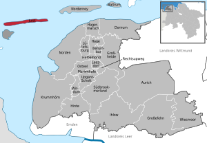
| Location of the municipality of Juist in the district of Aurich | ||
  |
||

Juist ( dt. [ Jyːst ], Dutch [ jœy̑st ]) is one of the East Frisian islands in the Lower Saxon Wadden Sea of the North Sea and lies between Borkum in the west and Norderney in the east. The island is 17 kilometers long, making it the longest of the East Frisian islands. The maximum width is 900 meters, the minimum 500 meters. On the island is the homonymous community of Juist , it belongs to the district of Aurich in Lower Saxony and has 1524 inhabitants. There are two districts on the island: the main town, which is divided into Westdorf and Ostdorf , and Loog .
geography


Juist is a German island in the southern North Sea. It belongs to the East Frisian island chain and is located in front of East Frisia . The island is 17 kilometers long, making it the longest of the East Frisian Islands. The maximum width is 900 meters, the minimum 500 meters. Juist is 16.43 square kilometers. The smallest distance to the mainland is around eight kilometers. In the west of Juist is the island of Borkum and in the southwest the bird island of Memmert . In the east, separated by the gorge , the Spaniergatt and the Norderneyer Seegatt , the island of Norderney . The Kachelotplate also extends between Borkum and Juist , developing from the high sand to the island, with the Osterems flowing further to the west . Parts of the island and the Wadden Sea around the island belong to the Lower Saxony Wadden Sea National Park . The island's dunes reach around 22 meters above sea level. NN. The highest dune carries the Juister water tower and is 22.1 meters above sea level. NN.
Land use
| Land use (as of 2005) |
Area in ha |
Share in % |
|---|---|---|
| Construction areas | 74 | 4.5 |
| Areas for common use | 5 | 0.3 |
| Traffic areas | 45 | 2.7 |
| Supply and disposal areas | 1 | 0.1 |
| Green spaces | 41 | 2.5 |
| Other areas | 1477 | 89.9 |
| Total area excluding coastal waters | 1643 | 100.0 |
The information given above for the traffic area includes areas for air traffic of 42 hectares. Agricultural areas, water areas as well as the areas for embankments and excavations have not been shown separately since 1993, but are included in the "Other areas". In the last statistics from 1987 the following values were given: agricultural areas (48 hectares), water areas (4 hectares) and the areas for embankments and excavations (2 hectares).
climate
The climate of the island of Juist is subject to the direct influence of the North Sea and is therefore in the range of a temperate, summer-cool maritime climate influenced by the Gulf Stream . Due to the balancing effect of the North Sea, there are generally lower daily and seasonal temperature fluctuations as well as high humidity . On average, the temperatures on the island are cooler in summer and milder in winter than the values measured on the mainland. Spring sets in around 2 weeks later. From January to July, less precipitation is measured on the island and more from August to December than on the mainland. On average, the amount of precipitation is lower and the duration of sunshine is higher than on the mainland. With 1,983 hours of sunshine, the island of Juist was the sunniest place in Germany in 2010.
According to Wladimir Köppen's climate classification , Juist is in the Cfb classification .
- Climate zone C : warm-temperate climate
- Climate type Cf : humid-temperate climate
- Climate subtype b : warm summers
The closest weather station is on the neighboring island of Norderney and is operated by the German Weather Service . The Norderney station with the station code 10113 has been providing freely available data for weather and climate monitoring since 1947 .
East migration of the island
The Juister beach and the dunes are removed from the sea in the west. Since 1976 the edge of the Bill has moved about 200 meters to the south. This development is caused by a shift in the current and an unbalanced sand balance. The sand on the beaches of all East Frisian islands moves with the prevailing wind direction from west to east. In areas where more sand is removed than blown or washed up, the beach becomes lower and narrower. This can lead to dune demolitions. This effect contributes to the east migration of the East Frisian islands . It was in all the islands except Juist and Langeoog , with revetments decelerated from concrete. On Juist there is a 1400 meter long protective wall on the north beach from 1920, which is now hidden under sand.
In some areas of Juist, for example in the east and on Kalfamer, more sand is washed ashore than removed, which leads to a very wide beach with an extension of the dune chain to the east.
history
The island was created as a sand deposit on remnants of the post-glacial mainland. Archaeological finds suggest that Juist was already settled before 1400 at the end of the chief's time. This was indicated by the discovery of a pig's head in an old well hole on the beach in 2002, which was dated to around 1400. The island was first mentioned in a document in 1398. At this time Juist belonged to the dominion of the chief family tom Brok .
The name Just previously referred to a branch on the large island of Bant . It is not known exactly when the independent island of Juist existed after the island of Bant was dismembered. In the 15th century, the island came under the influence of the East Frisian counts and princes of the Cirksena family .
16./17. century
According to a description by the later East Frisian Chancellor Henricus Ubbius from 1530, there are said to have been 23 houses and one wild horse breed. There was also a lot of arable and pasture land that offered favorable conditions for agriculture. After that, living conditions gradually deteriorated. The All Saints Flood caused severe damage in 1570 . On a map of the mouth of the Ems from 1642, the high tower of the first island church is entered in the middle of the island as a sea mark . The Petriflut of 1651 broke through the northern edge dunes in the area of the church and today's Hammersee and divided the island into two approximately equal parts. Over the years, the breakthrough reached a width of around two kilometers. The Petriflut damaged houses and eroded the foundations of the island church, which then collapsed in 1662. The Juisters built their second church about 700 meters to the southeast. Until 1687 the sea pushed further south, after which the Juister had to move their houses again. The work of destruction by the sea reduced the agricultural area, and in the 17th century the islanders could hardly raise the taxes on the count as owners.
18th century
The carnival flood of 1715 caused further destruction of the village and the second church. As a result, two villages emerged on the still divided island: Billdorf in the western and Loogdorf in the eastern part of Juist. Both received their own modest church building. Two years later, the Christmas flood in 1717 destroyed nine of the 18 houses in Billdorf and the church there. The rest were badly damaged. 28 people drowned. Billdorf was not rebuilt afterwards. The survivors moved to the Loogdorf. By this time, four churches had already been built and three had been destroyed. The islanders' economic prosperity had declined more and more. The main occupations of agriculture and animal husbandry were restricted by the fact that fertile arable and meadow land was lost through floods and sand drifts. The livestock had to be reduced more and more. In 1749 327 inhabitants, who were spread over 47 houses, lived on the island. Most of the men now went to sea and earned their living on merchant or whaling ships. In the following years the village moved further east, as the residents gradually demolished their houses and rebuilt them further east. Between 1770 and 1780 most of the islanders had settled in the new main village. In 1779 the fifth church was built in the new east village and consecrated at Christmas by Pastor Gerhard Otto Christoph Janus (1741–1805). In 1783 Janus recommended seaside swimming with a petition to the sovereign Frederick the Great . Today it is considered the oldest document on the history of German seaside resorts and Pastor Janus is the father of the German seaside resort concept.
19th century

After the Peace of Tilsit in 1807, East Frisia and with it Juist came to the French Kingdom of Holland . On November 10, 1811, Juist received Dutch occupation troops led by French officers. They had them convert the church in the eastern village into a fortress . The rectory served as accommodation for the soldiers. Two years later the rectory burned down as a result of the soldiers' carelessness. The occupation did not end until 1816 and the troops left the island. From then on Juist belonged to the Kingdom of Hanover and from 1866 to Prussia .
In 1840 the Juist seaside resort was first founded by Vogt Meine with the support of the District Assessor Fastenau in Norden , but it had to be closed again in 1858 due to a lack of guests. The second establishment of the seaside resort took place in 1866, this time more successfully, as the number of guests now slowly but steadily increased. In 1873, Baron von Niebelschütz issued the first bathing regulations. The first hot bathing house on the island was built in the same year. In 1884 Juist registered 700 bathers per year.
The "Association for the Rescue of Shipwrecked People in East Friesland" built the first sea rescue station on Juist in 1861. Two years later, the East Frisian Association and with it the station became the property of the DGzRS .
In 1882 Otto Leege (1862–1951) came to the island as a teacher. Leege began his botanical and ornithological research work, which later made him known as the "father" of the bird island Memmert . In 1888 he was on Memmert for the first time. During this time, bird hunts were undertaken there and egg collectors looted almost all the nestlings every year. On the initiative of the "German Association for the Protection of the Bird World", the Prussian Minister for Agriculture, Domains and Forests in Berlin declared Memmert a bird colony on July 31, 1907. The association then appointed Otto Leege from the association as an agent.

In 1894 Juist received its first landing stage. The steamer "Ostfriesland", which has been sailing to the island since 1888, was the first ship to dock at the 300 meter long jetty. In 1896 the landing stage was extended by 75 meters on the land side. On June 19, 1898, the Inselbahn began operating as a horse-drawn tram . The total length was 2318 meters, with 980 meters of track over low wooden walkways through the mudflats. The system fell victim to a storm that same year. It was decided to use a locomotive with a combustion engine after the railway system was rebuilt. On August 4, 1899, the railway was accepted for operation, making the Juist island railway the first motor-driven island railway in Germany.
20./21. century


In 1900 4534 guests visited the island. Of these, 3451 were spa guests and 1083 were day guests. Juist applied for vacationers, among other things, in advertisements as "The Jew-Free North Sea Bath" .
In 1902 the paddle steamer "Juist" was put into service. At the suggestion of Otto Leege, the goldfish ponds area was created by the Juist Beautification Association in 1903 . The Kommerzienrat Wilhelm Girardet from Essen, who owned a villa on the Juister beach promenade, donated a number of goldfish and gold orfe from his park , which gave the pond its name. From 1925 to 1935, Leege's initiative created the nature reserve on the Bill.
In 1925 the reform pedagogue Martin Luserke founded the Schule am Meer , a high school run as a boarding school . It was characterized in particular by the amateur play he introduced , which today is an integral part of many school offers and teacher training. The school was intended by the Prussian State Ministry for Science, Art and National Education and the Berlin Central Institute for Education and Teaching for the nationwide training of amateur play teachers. In 1930/31 it was the only German school to have its own theater hall , the largest reinforced concrete structure in East Frisia at the time. In 1934, the school by the sea was closed against the background of anti-Semitism and National Socialist conformity .
The extremely low temperatures of the winter of 1928/1929 temporarily cut off ship connections to the mainland. The mudflat was so frozen over that from February 11th to March 6th it was necessary to cross the mudflats on foot or with vehicles to get supplies. The link between Norddeich and Juist was about ten kilometers long. In the harsh winter of 1916/1917, Juist was first fed from the air when the Zeppelin L 16 landed at Kalfamer in February 1917.
In the years 1928 to 1932, a northern dike was built in front of Hammerbucht in order to finally end the division of the island into two. The southern area of the breakthrough was heavily silted up in 1870 and then secured with a dam. In the north, a storm surge broke through the new dike in 1932 and flooded the underlying terrain. The Hammersee was created. Over the decades, the brackish water developed into a freshwater lake.
From 1929 to 1932 the town hall, the post office and today's Kurplatz were built. From 1932 the planning for the construction of an airfield at Kalfamer began. In 1934 the project was completed with the inauguration.
During the Second World War , the spa business almost came to a standstill. Gun emplacements were built at various points on the island, and a mammoth radar was installed west of the Loogdorf . Allied bomber bombs caused considerable damage to some houses. After the end of the war, bathing was opened again on May 28, 1946. The first municipal council election took place on September 15, 1946. Paul Braunsdorf was elected first post-war mayor. On December 1, 1946, Juist had 1,509 inhabitants. Of these, 838 were locals, 81 were evacuated and 590 were refugees.
The winter of 1946/1947 brought traffic to the mainland to a standstill with six to eight meter high ice barriers. On March 17, 1947, a western storm with strong ice movement destroyed the Juister Landungsbrücke and the entire track system of the island railway. A makeshift landing stage was not completed until July 21 of the same year. In May 1949, the temporary structure could then be replaced by a new landing stage.
In 1978 the dike to the southern Wadden Sea was built. It runs from Ostdorf to Billstrasse and has a pedestrian promenade.
The rising maintenance costs for the island railway line prompted the community in 1980 to plan a new local port with a modern ferry pier and a port operations building. In 1982 the first passengers could be handled there. The island railway then ceased operations on March 10, 1982. In 1988 a lift bridge was added to the port. In 2001 the port operations building received an extension with a covered bridge connection to the ferry terminal. In the same year, the new terminal hall for all goods traffic on the island was built on the west side of the port.
After German reunification , Juist and Hiddensee signed an island partnership agreement on November 20, 1990. Juist supported Hiddensee in many ways in the following years. Employees of the municipality of Hiddensee were trained in the Juister municipal administration and the youth education center provided help with the expansion of the island museum on Hiddensee and with the training of youth group leaders. In 1997, 57 people from Hiddensee traveled to Juist for the partnership week.
In 1990 plans for a new runway were advanced at the airfield. The inauguration of the 700 meter long and 20 meter wide runway took place on May 2, 1991. The state of Lower Saxony contributed with a grant of 1.2 million DM.
As early as the 1990s, storm surges repeatedly caused severe damage to the Billdunes in the west of the island between Hammersee and Billriff. Dune demolitions on a broad front increasingly endangered island security. In November 2006, the hurricane "Britta" moved across the island, and the All Saints' Day flood again left the most severe dune demolitions there. Therefore, at the beginning of 2007, the Environment Committee of the Lower Saxony state parliament made an impression of the dune damage. Environment Minister Sander then personally traveled to the island. As a result, the bill reef dunes were strengthened over the next two years for 1.3 million euros. The length of the dune reinforcement was around one kilometer. Around 200,000 m³ of sand were poured back and then planted. The project was financed by funds from the State of Lower Saxony and the joint federal-state task to improve the agricultural structure and coastal protection .
In December 2013, hurricane Xaver once again caused severe damage to the dunes at the Hammersee. In September 2014, an extensive dune construction project took place.
Surname
The name of the island probably comes from the word güst “barren, barren”, which the island actually was for a long time. The island is often referred to as the longest or most beautiful sandbank in the world by the tourism industry and vacationers . Since the 1990s, the island by the spa with the addition will Toewerland provided, which is etymologically from the Middle Dutch word töver can be derived, which means "magic". The name Töwerland was already in use in the 19th century.
Religions

The Juister population has traditionally been evangelical since the Reformation . The Protestant parish looks back on a very eventful history with the multiple destruction of its church buildings by storm surges . Today's Evangelical Lutheran island church on Wilhelmstrasse is now the sixth church building on the island. The three by two meter mosaic “Petri Fischzug” above the altar, which Juister pupils worked on from 1960 to 1963, is worth seeing.
Only with the spa tourism that began in the 19th century, more and more Catholics came to the island as vacationers. A 1,901 of them established church building association brought the financial basis for the built in June 1910 church to the holy guardian angels at Janus space and chose in terms of children's holiday homes and the guardian angel - patronage .
The Evangelical Lutheran island parish and the Roman Catholic parish work together in a variety of ways. Since the summer of 2009, both churches have been publishing the joint ecumenical church newspaper “Uns Juister Karkenschipp” on the island of Juist. Ecumenical carolers are on the island and there are various occasions such as B. held ecumenical services on Thanksgiving .
Today's sixth island church was built in 1964 when the historic church from the 18th century was demolished. Monument protection did not (yet) play a role at this time. Photos of the demolition of the only island church on Juister that was not destroyed by the sea are exhibited in the island museum in Loog. In 1967 the new church received the campanile , which the Juisters call "rocket". In 1910 the Catholic island church was built.
politics
Municipal council
The council of the municipality of Juist consists of ten councilors and councilors. This is the specified number for a municipality with a population between 1001 and 2000 inhabitants. The ten council members are elected by local elections for five years each. The current term of office began on November 1, 2016 and ends on October 31, 2021.
The full-time mayor is also entitled to vote in the municipal council. Since December 1, 2016, this has been the directly elected mayor Tjark Goerges (Pro Juist).
| Political party | Proportional votes | Number of seats | change | |
|---|---|---|---|---|
| be right | Seats | |||
| CDU | 49.4% | 5 | + 0.3% | ± 0 |
| Pro Juist | 33.2% | 3 | + 8.8% | +1 |
| SPD | 10.0% | 1 | −0.8% | ± 0 |
| Alliance 90 / The Greens | 7.4% | 1 | −8.3% | −1 |
The turnout in the 2016 local elections was 54.2 percent, below the Lower Saxony average of 55.5 percent. For comparison: in the previous local elections on September 11, 2011, the turnout was 54.8 percent.
mayor
On September 9, 2001, the residents of Juist directly elected their mayor for the first time. The mayor also performs the duties of the community and spa director. The election was won by Karl Josef Wederhake from Beverungen with a result of 67.5 percent of the vote. On September 10, 2006, he was re-elected for a further eight years with 51.8 percent of the vote. He died on July 11, 2008.
The local council decided on an early direct election for the successor of the deceased mayor on November 30, 2008. Dietmar Patron was elected mayor of the island community with 55.4 percent of the valid votes cast; he accepted the election on December 1, 2008.
In the last mayoral election on September 11, 2016, Tjark Goerges (Pro Juist) received an absolute majority with 50.3 percent of the vote. His opponent Jörg Möllenbock, nominated by the CDU, received 43.39 percent of the votes, while the individual applicant Stefan Siedelmann (AFD) received 6.30 percent of the votes.
Representatives in the Land and Bundestag
The municipality of Juist belongs to the state electoral district 87 Wittmund / Insel , which includes the entire district of Wittmund and the cities of Norderney and Wiesmoor in the district of Aurich , the municipality of Dornum and the island communities of Juist and Baltrum . 15 parties ran for the state elections in Lower Saxony in 2017 . Six of these parties have put up direct candidates. The directly elected MP is Jochen Beekhuis from the SPD .
In federal elections, Juist belongs to constituency 24 Aurich - Emden . This includes the city of Emden and the district of Aurich. In the 2017 federal election , the social democrat Johann Saathoff was directly elected. No party candidate from the constituency entered the Bundestag via the parties' list.
Coat of arms, flag and official seal

Blazon : three golden dunes in blue; a six-pointed silver spur wheel in each of the upper corners, four silver corrugated strips at the bottom.
The island coat of arms was designed by Alf Depser , an electoral juister born in Nuremberg . A seal from the Evangelical Church Community of Juist served as a template. The dunes were taken from this. The two silver spur wheels indicate that it was part of the north district .
The flag consists of three equally wide stripes white, blue and yellow with the municipal coat of arms shifted slightly towards the Liek . The official seal contains the coat of arms and the inscriptionINSELGEMEINDE JUIST
Culture and sights
Museums and exhibitions

The Coastal Museum Juist is located in the Juist district of Loog, the smaller neighboring town west of the main town. On an exhibition area of around 500 square meters, the museum shows information and exhibits on the history of the island and baths, the history of settlements in the coastal area and the nature of the island and coastal protection. Every year around 20,000 people visit the exhibition.
The National Park House Juist , opened in 1990, is located in the old Inselbahnhof directly on Kurplatz. It is one of 14 national park houses and centers on the Lower Saxony coast. The free exhibition provides a wide range of information about the Wadden Sea National Park. The main attraction of the exhibition is the nine-meter-long skeleton of a minke whale stranded on Juist in 2001 . Other topics of the exhibition are the flora and fauna of the island. The underwater world of the North Sea can be discovered in seawater aquariums. In front of the national park house there is a tidal column around 2.5 meters high, which shows the current water level in the Juister Watt on a scale of 1: 3.
House Siebje , built in 1811, is located on Janusplatz in the center of the village . It belongs to a quartet of original island houses that stand around the square. The Heimatverein Juist e. V. acquired one of these houses and painstakingly restored it on its own initiative between 1983 and 1986. Handicraft exhibitions and vernissages by local artists take place regularly in the house . The upper floor houses the archive of the Heimatverein.
Buildings and sights

The Juist silhouette, visible from the North Sea, consists of the “House of the Spa Guest”, the water tower, the sea water adventure pool, the “Strandhalle” café-restaurant and the historic “ Kurhaus Juist ” beach hotel .

The historic Kurhaus, also known as the “White Castle by the Sea”, was opened on July 1, 1898 as the “Kurhaus Juist” beach hotel. A large staircase that used to lead from the hotel to the beach has silted up over time. In 1934 it was uncovered again, today only the visible pillars at its upper end testify to its existence. In 1984 the facade and the “White Hall” of the Kurhaus were placed under monument protection. From 1994 onwards, the entire building was extensively renovated , which was completed in 1998 with the complete reopening for the 100th anniversary of the building. Since the renovation, the Kurhaus has had a glass dome modeled on the German Reichstag building, which gives the building a very unmistakable appearance.

The water tower , built in 1927/1928, stands on the highest dune in Juist at 22.1 meters. The height of the water tower is 13 meters, so that the water tower towers above all other buildings on the island. However, it cannot be used as a lookout tower. Despite its age, the water tower is still an important element of the Juister water supply today, because it carries a 250 cubic meter reservoir to generate the necessary water pressure. The locals call the water tower " Doornkaatbuddel " because of its shape .

Originally Juist did not have its own lighthouse . The beacons on the neighboring islands of Borkum and Norderney were sufficient to guide shipping. The fact that there has been a small lighthouse on the island since the end of 1992 is thanks to an interest group consisting of the Heimatverein Juist, the sailing club Juist and the fishing community "NO.PO.NI.RE Fischereigenossenschaft AG". The interest group acquired the lantern house of the beacon on the neighboring bird protection island Memmert , which was closed in 1986, in Emden . The associated tower was rebuilt near the port and equipped with the purchased lantern house. The “Memmert Fire” has no meaning for shipping, but serves exclusively for tourist purposes. That is why it sends its light signals every 13 seconds across the island in a longitudinal direction so that its beacon cannot be seen from the sea. The lighthouse can be climbed from April to October.
The Kurplatz, which was renovated in the early 1930s and redesigned in 2005, is the center of the main town. This is where the music pavilion , inaugurated in 2004, is located , in which the spa orchestra, music groups and choirs perform several times a week during the season. For many, however, the center of the green area is the so-called Schiffchenteich , a shallow, former fountain basin on which generations of children have let their ship models drive.
The promenade of Juist runs through the dunes above the main beach from the beach entrance “Schoolpad” in the west to the beach entrance “Karl-Wagner-Straße” in the east. Since 2010 there have been three elaborately designed viewing platforms on the approximately one and a half kilometer long promenade , from which one can cast a wide view of the beach and the North Sea without entering the protected dunes. Other viewing platforms are located in the Loog and west of the Hammersee. In particular, the “Dree Water Uitkiek” at the “Loog” beach entrance, as the Low German name suggests, offers the opportunity to overlook three bodies of water from one vantage point: the North Sea in the north, the Wadden Sea in the south of the island and the Hammersee in the west.
The 7th degree of longitude crosses Juist in a north-south direction. At the intersection of the longitude with the Juister Kurpromenade, a bronze relief installed by the Juist Heimatverein has been pointing out this special feature since 2006 . In 2008, a duplicate of the bronze relief was to be installed on the promenade of the new pier, but precise measurements showed that the 7th degree of longitude ran a few meters east in the mudflats. The relief was nevertheless installed on the west-east part of the pier and the deviating relocation to 6 ° 59 '54 ″ East was documented with a note in the form of a bronze plaque.

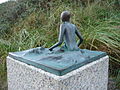
The bronze sculpture Juister Badefrau has been standing in front of the registry office in the building of the historic Warmbad since December 2003. It shows a naked, young girl who carefully dips one foot into the sea under the supervision of an old bather. The 50 centimeter high work of art is the work of the artist Karl-Ludwig Böke from Leer and was originally only the model for a larger-than-life bronze sculpture that the Juister Kunstverein wanted to donate to the community for the 150th anniversary of Juist as a seaside resort. After the implementation of the project had been postponed several times, a worthy location was sought and found at least for the model.
The Sandpipers , four small bronze sculptures by the sculptor Wolfgang Lamché from Ennigerloh, are located along the Juister Strandstrasse . The sculptures show four scenes of a bather on the way from the beach to the sea. The sculptures placed on granite steles were created in 2002 on the initiative of the “Art on Juist” working group of the Juister Heimatverein. The works of art were sponsored by islanders and guests.

Sculpture sandpiper IV
Sculpture sandpiper III

Sculpture sandpiper II

Sculpture sandpiper I


Since 2008 there has been another landmark with the sea mark , which was officially inaugurated on July 18, 2008. The 17 meter high sea mark, which is in the form of a buoy floating in the current and has a viewing platform, is located at the end of the approximately 350 meter long new pier. A new sport boat harbor with up to 212 berths was enclosed in it. Not only the costs of almost 6 million euros led to heated discussions among the islanders in advance, especially since in addition to EU and state funding, around 1.2 million euros of this had to be raised by the island community of Juist. Contrary to expectations, the alluvial silt still has to be dredged every year.
The Otto Leege Path , which was created between 2009 and 2011, is an ecological and artistic educational trail dedicated to the natural scientist Otto Leege (1862–1951) from Juister . It is located in the Juister east dunes between the main town of the island and Wilhelmshöhe. The approximately one kilometer long nature trail explains the nature of the dune island with its complex ecological relationships to the island guests and islanders . He crosses the island from south to north on his way.
Natural monuments
Hammersee


A natural history specialty is the Hammersee natural monument , the largest freshwater lake on a North Sea island. The inland water is found in the western third of the island. The name of the lake indicates its origin. "Hammer", from the East Frisian word "Hamrig", is a shared pasture area (see Alm in the Alps). The lake was created by flooding such a hamrig pasture.
As a result of the Petri flood of 1651, the island was initially divided into two parts. Around the year 1770 work began on filling up the approximately two kilometer wide breakthrough first on the south side, which was completed in 1877. It was not until 1928 that the north side facing the sea was closed with a sand dam. During a storm surge in 1932, the water broke through the northern dike, flooded the area behind it and no longer drained.
Over time, the salt content in Hammersee decreased - today it is a slightly brackish freshwater lake with reed beds , surrounded by chains of dunes. The Hammersee is subject to constant siltation .
It is an important feeding and resting area for insects and birds. Due to the surrounding forest and reed belt, the Hammersee is a relatively undisturbed area with a rich supply of food and, above all, fresh water. It is only accessible to people in a few places. Today's open water area is 17.3 hectares; including the silting zones, the wetland covers over 35 hectares. Its depth is around 1 meter on average.

The Bill - Juister Westende
.JPG)
In the west, Juist merges into a large sand bank, the Billriff (also called Schillplate). Here you can watch tens of thousands of migratory birds (especially dunlins , lapwing plover and knot ), especially during the bird migration season . For this reason and also because of dangerous quicksand areas , entering the Billreef is only allowed on the northern edge and only at low tide. At this end of the island is the "Domain Bill", formerly a domain , now a restaurant.
About 800 meters west of the Bill is the Kachelotplate , by the tidal creek Haaksgat separated from Juist. The North Sea island of Memmert is 1400 meters south , separated from Juist by the Juisterbalje Priel .
The Kalfamer - Juister Ostend

The Kalfamer is located at the extreme eastern end of the island and is an important bird resting and breeding area. On the Kalfamer, more sand is driven than removed, which is why this part of the island slowly grows to the east and thus forms the geologically youngest area of the island. The name Kalfamer comes from the Low German words "Kalv" for calf and "hammer" for low-lying, moist meadow and, in a sense, means calf meadow .
The area belongs to Quiet Zone I of the Lower Saxony Wadden Sea National Park and may only be entered without special tours from November 1st to March 31st on the route specifically approved for this purpose. The path is marked by green wooden stakes and can only be walked when the tide is low. The path begins a few minutes behind Juister Airport with an information board and ends at another in the northern dunes of the Kalfamer . During the breeding season from April 1 to October 31, access to the Kalfamer is only possible as part of a guided tour that has been booked in advance . Compliance is monitored by appropriate national park staff.
Green spaces
The Janus place is the central park in the main town of the island. It got its name in honor of Pastor Gerhard Otto Christoph Janus (1741-1805), who worked as a pastor on Juist from 1772 to 1789. In 1783 Janus recommended bathing at the seaside with a petition to the sovereign Friedrich the Great . The petition is now considered the oldest document on German seaside resort history and Pastor Janus is the father of the German seaside resort concept. Four of the oldest houses on the island are on Janusplatz. The house Raß from 1802 is the oldest, it follows the House Siebje of 1811, the House Wäcken of 1852 and the former island weaving house Hoff of the 1856th
Sports
The gymnastics and sports club TSV Juist e. V. is the largest sports club on the island with around 320 members. The sports hall and the sports field of the island school are available to the club as play areas. The men's soccer team disbanded in October 2018 due to a lack of players. Previously, the team, which, due to the island's dependence on the tides, had played their league games ( Ostfrieslandklasse C, Season 1 ) on the mainland in a double pack, had become known nationwide through these double game days.
The sailing club Juist e. V. was founded in 1936 by five fellow sailors. In 2011 the 75th anniversary was celebrated. Since the summer of 2008, the sailing club has also operated the new Juister sports boat harbor. The new port was created as part of the construction of a 334-meter-long lake promenade for the new navigation mark at the port entrance. The area enclosed by the promenade offers space for up to 212 berths. The club's floating jetty currently offers 163 berths.
There are facilities for tennis and boules on Juist . As a replacement for the disused mini golf course , areas in the intermediate dike area or on the tennis courts are being considered. There are also offers for windsurfing and kite surfing . In addition to various running events and a short triathlon , tournaments for beach soccer and beach volleyball are regularly organized for spa guests .
Regular events
- Ascension Day: Juister Music Festival (since 2000)
- July: Juister family festival (since 2008)
- September: Crime festival Tatort Töwerland (since 2006)
- October: Insel-Musikfest (since 2009)
- October: Classic Days Juist (since 2004)
fauna
In addition to the numerous animals of the Lower Saxony Wadden Sea National Park , Juist also has small animals and birds such as the hare and the pheasant . Most recently, biodiversity was examined on the “GEO Day of Species Diversity” 2016 on Juist. 71 species of birds, 54 species of butterflies and 70 species of beetles were detected.
Economy and Infrastructure

The tourism is the main source of income for the islanders. Almost all houses on the island have accommodations that are rented out to holidaymakers. In the high season there are up to four times as many tourists as locals on the island, in 2008 there were 89,015 guests (589,664 overnight stays). Despite the sometimes cooler sea weather in the summer months and the high price level, the island is regularly booked out in the high season.
The car-free island of Juist is - like the other East Frisian islands - a North Sea spa . The aerosol-containing sea air is created by small salt water droplets that are whirled up with the surf . Juist is therefore a popular holiday destination for people with breathing difficulties, but also recommended for serious skin problems such as neurodermatitis and, due to the irritating climate, also for psychosomatic disorders.
The DJH youth hostel of Juist is located in the smaller Juist district of Loog . The offer of the 300-bed house on Loogster Pad is usually aimed at school classes or larger groups, but the youth hostel also has 12 family rooms . The institution is run by the DJH Landesverband Unterweser-Ems e. V.
There is no campsite on Juist . In addition, "wild camping" or camping on the island is expressly prohibited.
Like all East Frisian islands, Juist also levies a separate spa tax that is only used for local tourist purposes. The so-called TöwerCard, a credit card-sized service and serves to collect Kurbeitragskarte . You can get them when you buy a ferry or plane ticket or on the island. When crossing the turnstiles at the port or at the airport, the respective arrival date is written electronically on the TöwerCard. Before departure, the spa tax must be paid at one of the service points in the town hall, at the harbor, in the sea water adventure pool or in the coastal museum in the Loog. In addition to billing the resort fees, the TöwerCard as a service card includes other services, such as B. free entry to the sea water adventure pool per day for one and a half hours. All service points on the island also serve as tourist information , accommodation agencies, room certificates and advance booking offices for events.
Juist has joined the marketing organization Die Nordsee GmbH in Schortens for the tourist marketing of the island . The company represents the seven East Frisian Islands and 15 coastal towns in Lower Saxony. It is responsible for joint press work, marketing, holding trade fairs and events, creating print media and classifying private holiday accommodation. The overarching advertising slogan is “the North Sea, seven islands - one coast”. Juist himself has been advertising since the 1990s with the addition "Töwerland", which is derived from the Frisian word "Töwer" = magic and means magic land .
In addition to the health resort contribution, the municipality of Juist has been collecting a second home tax since December 19, 2000 as well as a tourism contribution from locals who gain direct or indirect economic benefits from tourism.
Shipping

Juist can be reached from the Norddeich Mole train station and pier on the East Frisian mainland with the ferries operated by the Norden-Frisia shipping company based on the neighboring island of Norderney to the east . The ferries run once or twice a day depending on the tide . The ferry crossing usually takes 90 minutes, depending on the tide and wind conditions sometimes longer. With the exception of the summer months of July to September, the ferries only run once a day to the island and the mainland. Day visitors are only on the island on certain days due to the tide-dependent timetable. The island is also supplied with goods by cargo ferry. According to information from the shipping company Norden-Frisia, the freight volume amounts to 23,000 tons per year. In 2017, 346,000 people were transported. That was 3.7% less than in the previous year.
Since 2019, the island has also been connected to Norddeich with the less tide-dependent fast ferry service Töwerland-Express .
The sea rescue boat " Hans Dittmer " of the German Society for Rescue of Shipwrecked People (DGzRS) is stationed on Juist . The red and white lifeboat of the 10.1 meter class was delivered in 2017 from the Fassmer shipyard in Berne on the Lower Weser and named Juist in April 2017. The Otto-Mann-Haus, the station house of the DGzRS on Juist, is located directly at the DGzRS pier. In the summer of 2011, the Juister Station was 150 years old.
The excursion boat “Wappen von Juist” is usually located in the port of Juist. She regularly goes on day trips to Borkum and Norderney. Excursions to the seal banks or crab catching trips as well as tours around the bird island of Memmert are also offered.
Island traffic

All motorized traffic is strictly prohibited on the car-free island. Instead, horse-drawn carriages are usually used on the island for people and horse- drawn vehicles for transporting goods. There are four large horse-drawn haulage companies on Juist with around 50 teams , another five teams are used by the three local beverage distributors. The work areas of the individual haulage companies are clearly demarcated, each company is responsible for certain tasks, e.g. B. Port transshipment in Juist, horse taxi, garbage disposal on behalf of the Aurich district or transport links with covered wagons and passenger carriages to Juist airport.
Exceptions to the freedom of motor vehicles can be granted upon written application. Vehicles of the fire brigade and the rescue service, the cars of the (emergency) doctors, a minibus for the youth education center, tractors and construction machines are permanently excluded. Deutsche Post AG uses some electric carts for transport purposes. The garbage disposal is also accomplished with the help of horse-drawn vehicles. The construction machines used for the construction of the pier, which was officially inaugurated on July 18, 2008, received special permits.
Air traffic

The Juist Airport (IATA: JUI / ICAO: EDWJ) lies to the east of the island, about four kilometers from the island's capital. After Hanover Airport , it ranks second in terms of flight movements in Lower Saxony. One reason for this is the tide-dependent ferry traffic, which only allows ferries to call at Juist at certain times.
The airline FLN Frisia-Luftverkehr in Norddeich operates a year-round service with fixed departure times from the Norden-Norddeich airport to the Juist airport. The flight time is only around five minutes. The only scheduled flight from Juist is the Juist - Hamburg route and is served by the Ostfriesische Lufttransport airline . It is flown all year round, but only under visual flight conditions . In 2017, 52,000 people were transported. That was 2.4% more than in the previous year.
In September 2014, Deutsche Post DHL announced a pilot operation from September 26, 2014 until the end of the year with a drone called a parcel copter . This is to transport medication in an autonomous flight in a special transport container over the twelve-kilometer route from the city of Norden on the mainland to a pharmacy in Juist.
Island railway
From 1898 to 1982 the Juist Island Railway ran from the old jetty to the station on the outskirts, previously via the Pfahljoch route . It was the first motorized island railway in Germany with a gauge of 1000 millimeters ( meter gauge ). In the years 1979 to 1981 a new, local port was built. The island railway was then shut down in 1982, which was then only used for dismantling work. The old station building now houses a restaurant and the Juist National Park House.
Rescue station of the DGzRS


One of the oldest stations of organized sea rescue in Germany was set up in Juist by the Emden Association for the Rescue of Shipwrecked People on the East Frisian coasts . A 26-inch Francis boat was available for each of the Ostland and Westland stations. The stations were taken over in 1868 by the German Society for Rescue of Shipwrecked People (DGzRS). After the rowing lifeboats used at the beginning, a motor lifeboat came to the island for the first time in 1940 . However, the station was closed in 1957.
It was not until 1985 that the DGzRS stationed a lifeboat on the island again. After eight years with the Juist, the seven-meter-long Ilka was replaced by a new 8.5-meter-class boat . The current design of the DGzRS with a closed control station was used from 2006 with the 9.5 meter long Wolterra . In 2017 the DGzRS moved this boat to the Baltic Sea. Instead, a further developed boat of this class came, the 60 centimeters longer Hans Dittmer . In 2002, the island's volunteers received a new station building called Otto-Mann-Haus in the harbor directly at the pier .
media
Juist belongs to the circulation area of the daily newspaper Ostfriesischer Kurier . Since July 2, 1867, it has been the home newspaper for the city of Norden and its surrounding communities, as well as the North Sea islands of Norderney, Juist and Baltrum. In addition, the islanders receive the weekly newspaper "Echo" from the same publisher. Due to the tide-dependent ferry schedules, the mainland newspapers are delivered to the island daily by plane.
The free, around 100-page Juister information brochure "Strandlooper" appears monthly during the season and has been informing island guests and islanders about the current program of events on the island as well as topics from the history of Juist and life on Juist since 1999. The Strandlooper is financed solely through advertisements. The total annual circulation is 45,000 copies.
The "JNN: Juist Net News" is the online newspaper for the island of Juist. She publishes daily news about everything that has to do with Juist.
education
The only school on Juist is the "Inselschule Juist" on Schoolpad in the west of the main town. The school in the middle of the dunes is a primary, secondary and secondary school. In the 2012/13 school year, it was converted into a primary and secondary school (i.e. the secondary and secondary schools are gradually being phased out). In 2011, 103 pupils attended the school and are taught by around ten teachers. Because of insufficient class sizes, classes have to be merged and taught together. Schoolchildren from the island who want to do their Abitur attend the Lower Saxony boarding high school in Esens . Over 90 percent of the students at this boarding school come from the East Frisian Islands. In July 2018 three Juister students received their Abitur.
Between 1925 and 1934 there was a school by the sea , founded by the reform pedagogue Martin Luserke , in the western district of Loog , which took its students from sixth to high school and university entrance qualification (Abitur). Some of the school buildings are still there and are used as a coastal museum and as the main building of the DJH Youth Hostel. The theater hall of the former school was integrated into the youth hostel as the Inselburg house. The Schlaffhorst-Andersen school for language education also existed in the Loog .
Public facilities

The joint municipality and health resort administration of the island is mainly housed in two buildings: the town hall in Strandstrasse and the regulatory and registry office in the "Alten Warmbad" on Friesenstrasse. The administration is also responsible for the waterworks and the sewage treatment plant , the building yard and the adventure pool on the island. The spa administration operates the service points with room brokerage and room records and is responsible for marketing and event management. The mayor as the head of the municipal administration is also the head of the spa administration as the spa director.
In the house of the spa guest also various events are held, including concerts, cabaret and theater performances. The building also houses reading and seminar rooms, table tennis and pool tables and an internet café .
The Juist Foundation has been promoting projects for the island's well-being since 2006 .
Personalities
Sons and daughters of the island
The following people were born on the island of Juist:
- Christian Jasper Klumker (born December 22, 1868 - † July 19, 1942), German social worker
- Hilke Rosenboom (born May 11, 1957 - August 15, 2008), German journalist and writer
- Alfred Behring (born March 18, 1919 - † May 2, 1988), most famous mudflat guide and original from Juist
- Uwe Kolbe (* 1966), German film producer
Connected to the island
The following people were not born on Juist, but worked on site:
- Gerhard Otto Christoph Janus (1741–1805), German Reformed pastor, suggested in a petition to Frederick the Great in 1783 to set up a seaside resort in Juist
- Otto Leege (1862–1951), German scientist, "father" of the East Frisian bird protection island of Memmert and educator
- Martin Luserke (1880–1968), reform pedagogue, storyteller and writer, founded and directed the school by the sea in Loog
- Peter Smidt (1894–1957), poet and writer, is considered to be Juist's “gymnastics father”
- August Theodor Wuppermann (1898–1966), steel entrepreneur, sponsor and co-founder of the Society for the Promotion of Glider Flight e. V. Juist
- Alf Depser (1899–1990), artist, designed the island's coat of arms, among other things
- Arend Lang (1909–1981), doctor, National Socialist, cartographer and private scholar, was director of the Coastal Museum in Juist until 1981
- Christine Brückner (1921–1996), German writer
- Hans Kolde (* 1925), German flight instructor, honorary citizen of the islands of Juist and Hiddensee
- Renate Kolde (1931–2012), journalist and pilot, first and longest-serving German flight controller
- Sandra Lüpkes (* 1971), crime writer, singer and editor
Known people related to the school by the sea
literature
- Peter Smid: The island of Juist . Otto Meissner Verlag, Hamburg 1936.
- Christine Brückner (Ed.): Juist. A reader. Ullstein publishing house, Frankfurt am Main 1984, ISBN 3-550-06464-0 .
- Manon Loock-Braun: Out and about on Juist. Natural and cultural-historical island walk. Husum Verlag, Husum 2002, ISBN 978-3-89876-037-9 .
- Silke Arends: Töwerland, Zauberland Juist. Verlag Soltau-Kurier-Norden 2007, ISBN 978-3-928327-85-5 .
- Cornelius Janssen and Elisabeth Tobaben: Five island churches in five centuries. An excerpt from the history of the island of Juist. Uns Karkenshipp, special issue, 4th edited edition, Juist 2019.
- Jochen Büsing: In the Loog: the checkered history of the other Juister district. Burchana Publishing House. Borkum 2010.
- Bernd Flessner : 111 places on Juist that you have to see , Emons Verlag, Cologne 2019, ISBN 978-3-7408-0548-7
- Bernd Bunk : Seal. Yearbook for the North Sea Spa Juist. Volume 1–6, Loog-Verlag, Juist 1975–1980.
Web links
Individual evidence
- ↑ State Office for Statistics Lower Saxony, LSN-Online regional database, Table 12411: Update of the population, as of December 31, 2019 ( help ).
- ↑ The Juist water tower. Juist municipality and spa administration, accessed on September 8, 2019 .
- ↑ NLS-Online: Table Z00100001 Land use types - 452013 Inselgemeinde Juist State Office for Statistics and Communication Technology Niedersachsen-Online (LSKN), accessed on June 4, 2011.
- ↑ Climate in the area of the East Frisian Islands , accessed on May 29, 2011.
- ↑ Statista.de: The ten sunniest places in Germany in 2010 , viewed on September 17, 2012.
- ↑ Overview of the stations with freely available values . German Weather Service (DWD). Retrieved June 27, 2011.
- ↑ a b c d e f g h i j k l m n o p q Juist: Historisches , accessed on May 28, 2011.
- ↑ Cornelius Janssen: Five island churches in five centuries. An excerpt from the history of the island of Juist. Uns Karkenshipp, special issue, Juist 2008.
- ↑ Sight on the North Sea island of Juist: Goldfish pond ( memento from November 25, 2010 in the Internet Archive ), accessed on May 28, 2011.
- ↑ Martin Luserke , on: deutsche-biographie.de, accessed on March 31, 2016
- ^ Jochen Büsing: Coastal Museum Juist, collection and documentation School by the sea.
- ↑ Strandlooper Juist, August 2019, p. 21 ff.
- ↑ Airship landing on Kalfamer (1917) , accessed on July 16, 2012.
- ↑ Sand transports on Hammersee are in full swing Juist Net News, September 2, 2014, accessed on September 25, 2014.
- ↑ Duden. Etymology. 2nd edition 1989.
- ↑ Ecumenical church newspaper of the island Juist "Uns Juister Karkenschipp" , accessed on February 13, 2016.
- ^ Lower Saxony Municipal Constitutional Law (NKomVG) in the version of December 17, 2010; Section 46 - Number of MPs , accessed on December 30, 2016.
- ^ Inselgemeinde Juist - Councilors , accessed on December 5, 2011.
- ↑ Local council election 2016: three votes for one deceased , accessed on December 30, 2016.
- ^ Election gleanings: participation was below the national average , accessed on December 30, 2016.
- ↑ The CDU gets the most votes nationwide. September 12, 2016, accessed December 30, 2016 .
- ↑ Conceivably narrow majority in the mayoral election of Juist , accessed on December 30, 2016.
- ^ Nordwest-Zeitung: Bundestag election: These members represent our region . In: NWZonline . ( nwzonline.de [accessed September 29, 2017]).
- ↑ Heiko Jörn: Alfred (called: Alf) DEPSER . East Frisian landscape. Retrieved June 12, 2011.
- ↑ Inselgemeinde Juist: Main Statute ( Memento of February 13, 2016 in the Internet Archive ) (PDF; 47 kB). Accessed July 16, 2013.
- ↑ Coastal Museum in Loog - Tour , accessed on May 31, 2011.
- ↑ https://www.nationalparkhaus-wattenmeer.de/nationalpark-haus-juist/aquarien
- ↑ Sight on the North Sea island of Juist: House Siebje ( Memento from November 4, 2010 in the Internet Archive ), accessed on May 31, 2011
- ↑ The Juist water tower. Juist municipality and spa administration, accessed on September 8, 2019 .
- ↑ What is NO.PO.NI.RE. AG? ( Memento of May 24, 2015 in the Internet Archive ), accessed June 13, 2011.
- ↑ Sight on the North Sea island of Juist: Memmert Fire ( Memento from April 7, 2011 in the Internet Archive ), accessed on June 13, 2011.
- ↑ Sight on the North Sea island of Juist: Kurplatz and Schiffchenteich ( Memento from April 7, 2011 in the Internet Archive ), accessed on July 10, 2011.
- ↑ Sight on the North Sea island of Juist: viewing platforms on the beach promenade ( memento from April 7, 2011 in the Internet Archive ), accessed on June 10, 2011.
- ^ Coast Museum on Juist im Loog - The 7th degree of longitude , accessed on July 10, 2011.
- ↑ How an old man, 2.30 meters high, became a beautiful 50 cm high nude , accessed on June 8, 2011.
- ↑ Sea mark on Juist from ostfriesland.de, accessed on December 22, 2014.
- ↑ a b c Juist pier - a new landmark for Juist , accessed on June 2, 2011.
- ↑ Sight on the North Sea island of Juist: Otto-Leege-path ( Memento from April 7, 2011 in the Internet Archive ), accessed on June 14, 2011.
- ↑ The flora and fauna of the East Frisian Islands - Juist , accessed on October 9, 2011.
- ↑ a b Sight on the North Sea island of Juist: Kalfamer , accessed on June 13, 2011.
- ^ Silke Arends: Juist - Töwerland | Magic land . Verlag Soltau-Kurier-Norden 2007, ISBN 978-3-928327-85-5 , page 111.
- ↑ Strandlooper Juist, August 2019, p. 18.
- ^ Ostfriesischer Kurier of June 22, 2011 ( memento of July 9, 2011 in the Internet Archive ), accessed on February 13, 2016.
- ↑ Strandlooper Juist, May 2011, page 105 ff.
- ↑ Strandlooper Juist, August 2019, page 11.
- ↑ Sports and activities on the North Sea island of Juist , accessed on July 16, 2012.
- ^ Juist in the Wadden Sea World Heritage Site
- ↑ NLS-Online: Table K7350001 Accommodation for tourists - accommodation establishments with at least 9 beds . State Office for Statistics and Communication Technology Lower Saxony (LSKN). Retrieved June 8, 2009.
- ↑ Juist Youth Hostel. German Youth Hostel Association , accessed on September 7, 2019 .
- ↑ Spending the night on Juist , accessed on June 18, 2011.
- ↑ TöwerCard - your service and Kurbeitragskarte , accessed on 17 June 2011th
- ↑ Places and Islands. Nordsee GmbH , accessed on September 8, 2019 .
- ↑ Second home tax statute of the municipality ( Memento of February 13, 2016 in the Internet Archive ) (PDF; 123 kB), accessed on June 17, 2011.
- ^ Community of Juist: Finance , accessed on June 17, 2011.
- ↑ Michaela Kruse: Reederei Norden-Frisia has new ship christened . October 29, 2010. Retrieved July 10, 2011.
- ↑ Strandlooper Juist, August 2019, page 13.
- ↑ Thorsten Hapke: The Reederei Rebel von Juist. In: Typical! Norddeutscher Rundfunk , February 6, 2020, accessed on February 12, 2020 .
- ↑ Toewerland-Express.de
- ↑ Strandlooper Juist, May 2011, p. 100ff.
- ↑ Visit to Juist ( memento from June 17, 2016 in the Internet Archive ), accessed on June 12, 2011.
- ↑ Strandlooper Juist, August 2019, page 13.
- ↑ Yellow flying object over Juist. Deutsche Post is testing “Paketkopter” . n-tv - member of the media group RTL Germany. September 24, 2014. Retrieved September 25, 2014.
- ^ Station Juist of the DGzRS. In: seenotretter.de. German Society for the Rescue of Shipwrecked People, accessed on June 28, 2020 .
- ^ Ostfriesischer Kurier , accessed on February 13, 2016.
- ↑ Strandlooper, information and Juist stories , accessed on June 11, 2011.
- ^ Online newspaper - JNN: Juist Net News , accessed June 11, 2011.
- ↑ [1] , there community Juist and 2011 tick and have a table drawn up.
- ↑ Inselschule Juist .
- ↑ Strandlooper Juist, August 2019, page 15.
- ↑ Organigram 2018. (PDF) Juist municipality and spa administration, accessed on September 8, 2019 . (PDF; 126 kB)
- ^ House of the spa guest. Juist municipality and spa administration, accessed on September 8, 2019 .
Aurich | Baltrum | Berumbur | Dornum | Großefehn | Großheide | Hage | Hagermarsch | Half moon | Rear | Ihlow | Juist | Krummhörn | Leezdorf | Lütetsburg | Marienhafe | North | Norderney | Osteel | Rechtsupweg | South Brookmerland | Upgant bulkhead | Wiesmoor | Willum
Non- parish area in the Aurich
Memmert district
Borkum | Bant | Lütje Hörn | Brauerplate | Tile plate | Memmert | Juist | Norderney | Baltrum | Langeoog | Spiekeroog | Wangerooge | Minsener Oog | Mellum
|
The next island to the west: Memmert |
East Frisian Islands |
The next island to the east: Norderney |