Alpl (pass)
| Alpl | |||
|---|---|---|---|
|
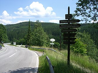
Weizer Strasse am Alpl |
|||
| Compass direction | northwest | Southeast | |
| Pass height | 1081 m above sea level A. | ||
| District / Region | Bruck-Mürzzuschlag / Mürz Valley | Weiz / Eastern Styria | |
| Watershed | Fressnitzbach → Mürz → Mur → Drau → Danube | Hirschbach → Feistritz → Lafnitz → Raab → Danube | |
| Valley locations | Krieglach | St. Kathrein am Hauenstein | |
| expansion | Weizer Strasse (B72) | ||
| Mountains | Fischbacher Alps : Hochlantsch / Stuhleck | ||
| particularities | Road over the Alpler Schanz side pass ( 1089 m above sea level ); Fortification from 1704 | ||
| map | |||
|
|
|||
| Coordinates | 47 ° 29 '48 " N , 15 ° 38' 50" E | ||
The Alpl ( 1081 m above sea level ) is a pass in the Fischbacher Alps in Styria .
Location and landscape
The Alpl is the deepest notch between the Hochlantsch ( 1720 m ) and the Stuhleck ( 1782 m ) and forms the watershed between Mürz and Feistritz . The pass connects the local community of St. Kathrein am Hauenstein and the market community of Krieglach . The border between the Weiz and Bruck-Mürzzuschlag districts runs across it . Alpl , which belongs to Krieglach, is located on the north ramp of the pass road, while the Alpler Schanz was located on the pass .
History and expansion
The Weizer Straße (B72) leads over the Alpl , whereby the road does not run over the top of the pass itself - at the Gasthof Schlagobersbauer - but around 400 meters north over the slightly higher side pass Alpler Schanz ( ⊙ 1089 m ). The road is very busy with cars and trucks.

There is an old defense system at the pass, the Alpler Schanz . This facility was built in 1704. It was one of the fortifications ( Kuruzzenschanzen ) that were built at the beginning of the 18th century in the east of Lower Austria and Styria against the Kuruzzen uprising (in the course of the War of the Spanish Succession ). At that time there was a danger that the Kuruzzen would invade the Mürz Valley and endanger Upper Styria. This did not happen, but the passes of the Fischbacher Alps and thus also the Alpl were kept ready for defense for a long time. The facility consisted of an earth wall with a trench in front of it, a jump . Only small remnants are left. It has not been proven whether older systems from the time of the Turkish wars around 1532 were used when they were built.
Rosegger's birthplace , on the mountainside opposite to the west, clearly visible from the pass road
Hydrography
Some streams in the Alpl are examples of river taps , in which the course of a stream changes because another, steeper flowing body of water gnaws the area around this stream, which ultimately leads to the original course of the stream being abandoned and its water to Direction of the steeper river follows. As a result, the watershed bulges slightly to the east on both sides compared to the relatively uniform course on the main ridge of the Fischbacher Alps.
Also marks the Alpl that point the Mur-watershed at which it from the east-west direction along the Mur-Murz furrow (from Semmering parallel to) of the north-south direction Murdurchbruch begins to bend and the lower Mur. It then goes over the Schanzsattel , then finally takes the south direction at the Gschießkogel near Thyrnau .
Individual evidence
- ^ ÖK50 In: www.austrianmap.at , Federal Office for Metrology and Surveying, Austrian Map
- ^ Fritz Posch: Flaming Frontier. Styria in the Kuruzzenstürme. 1st edition. Verlag Styria Graz 1968. p. 26. 2nd edition as: Publications of the Steiermärkischen Landesarchives . Volume 5. Styria, Graz-Vienna-Cologne 1986. ISBN 3-222-11691-1 ZDB -ID 561078-3 .
- ^ Sieghart Otto Morawetz: Tapping in the Styrian Edge Mountains and its surroundings. In: Communications from the Natural Science Association for Styria. Graz 1976. Volume 106. ISSN 0369-1136 ZDB -ID 206167-3 . Pp. 82-83.


