
Auer (South Tyrol)
| Except | |
|---|---|
| (Italian: Ora ) | |
coat of arms
 |
map  |
| State : | Italy |
| Region : | Trentino-South Tyrol |
| Province : | Bolzano - South Tyrol |
| District community : | Überetsch-Unterland |
|
Inhabitants : (VZ 2011 / 31.12.2019) |
3,556 / 3,875 |
|
Language groups : (according to 2011 census ) |
69.74% German 29.59% Italian 0.67% Ladin |
| Coordinates | 46 ° 21 ′ N , 11 ° 18 ′ E |
| Altitude : | 217– 900 m slm (center: 242 m slm ) |
| Surface: | 11.82 km² |
| Permanent settlement area: | 8.2 km² |
| Neighboring municipalities: | Aldein , Branzoll , Montan , Pfatten , Tramin |
| Postal code : | 39040 |
| Area code : | 0471 |
| ISTAT number: | 021060 |
| Tax number: | 80010730218 |
| Mayor (2015): | Roland Pichler (Together for Auer) |
Auer ([ ˈaʊ̯ɐ ]; Italian Ora ) is a market town with 3875 inhabitants (as of December 31, 2019) in the South Tyrolean lowlands in Italy , about 16 kilometers south of Bolzano .
Surname
The name Auer developed after Egon Kühebacher from a derivation of the Old High German ouwa and thus means something like "water", "land surrounded by water", "peninsula", which refers to the location of the village on the course of the Schwarzenbach. In the course of history, the name developed through spellings such as Aura , Owra , Awer or Aur to the modern place name Auer , which prevailed at the beginning of the 19th century. In the local dialect, the place name [ ˈaʊ̯r ] is pronounced.
geography

Auer is located in the Unterland , as a section of the Adige Valley in the south of South Tyrol from Bozen to the Salurner Klause is called. The municipal area, a total of 11.82 km², extends largely on the orographically left (eastern) side of the valley between Branzoll in the north and Neumarkt in the south and only crosses the Adige in the south-west towards Tramin with a small section . The built center (220- 280 m slm ) is mainly on a alluvial fan of Black brook , which here from the east from the Fiemme Mountains Coming reaches the valley floor. While the community ends immediately south of the community center on the hill of Castelfeder and borders on Montan there , it extends northwards far towards Pfatten and Branzoll. Auer reaches its highest points on the steep slopes of the Regglberg flanking the lowlands on the east side , through which the border to the neighboring municipality of Aldein runs.
history
During the Middle Ages and the Early Modern Age, Auer was part of the Enn court and, with the St. Peters Church, had also been the old parish center of the area since the 12th century. The village settlement of Auer emerged as an independently acting association as early as the 15th century, as evidenced by a corresponding document from 1463 with the express mention of the "comunitas ville Awer" - the community of the village of Auer - and their Riegler (land manager). A number of magnificent residences, such as Fioreschy (Auer Castle), Steinkeller, Staffler and Baumgarten, testify to the old prosperity of the place.
Until the end of the First World War, Auer belonged to the County of Tyrol and thus to Austria-Hungary . Within Tyrol, Auer was assigned to the Neumarkt judicial district , which in turn was part of the Bozen district . With the Treaty of Saint-Germain , Auer came to Italy in 1920 along with most of Tyrol south of the main Alpine ridge . When the two provinces of Bolzano and Trento were established in these formerly Austrian areas in 1927, Auer, as well as some other surrounding communities, was added to the predominantly Italian-speaking province of Trento. It was not until 1948 that Auer was incorporated into the province of Bozen or South Tyrol.
Important personalities visited Auer

1551 : The elephant Soliman came to the inn "In der Ilben" (today's Hotel Elefant). It was a gift from King John III. from Portugal to his nephew, the then Archduke Maximilian in Vienna . The elephant came with his companions and took a rest "In der Ilben" to strengthen himself for the onward journey to Vienna. In the lobby of today's Hotel Elefant (name from 1826) there is a memorial plaque with the slogan: “Once upon a time, a large elephant came to our country from the south. In this house there he stopped and ate and drank a lot of good wine. Satisfied, happy and cheerful, he then moved on again ”.
1765 : Emperor Franz I went to Innsbruck with his wife Empress Maria Theresa to prepare for the wedding of their son Archduke Leopold. Empress Maria Theresa stayed in Innsbruck while Franz I traveled to meet his daughter-in-law, the Spanish Infanta Maria Ludovica . Their meeting took place in the Abrahamhof (today's post office).
The legend: the fall of the golden city of Auer
“At the site of today's village of Auer, there was once a large city that was called the 'Golden City' because of its beauty and wealth. However, since the residents led a dissolute and vicious lifestyle, God decided to destroy the city. One day an angel appeared to the only God-fearing youth and brought him the message that he should go to the mountain the next morning, then he would see the miracles of the Lord. He did as he was told. Once the floodgates of heaven were opened and he witnessed how the sinful city in the waters sank - only one and St. Peter's alone remained miraculously spared. " (Excerpt from a culturally hiking guide for Auer Aldino-Neumarkt-Montan-Truden-Altrei, traffic group Auer) Today the fresco on the building of the Sparkasse reminds of the legend.
Attractions

Town center
Large parts of the town center located up the slope consist of narrow, winding, cobblestone streets with natural stone walls that are often taller than a man on both sides.
St. Peters Church

The St. Peters Church is located at the southern entrance to the town on the old state road in the direction of Neumarkt . Since it was first mentioned in a document in 1183, the sacred building is likely to be the oldest building in the community. In its current form it is a Gothic building from the 16th century with a Romanesque church tower from the 12th century . St. Peter was originally incorporated into the monastery of San Lorenzo in Trento. Due to frequent floods and the resulting rock and earth deposits, the parish church is about five meters lower than the surrounding area. The church entrance can therefore be reached via a staircase leading downwards.
Marienkirche
The Marienkirche (full name: Our Lady of the Rosary) is located in the traffic-calmed, historical center (Oberdorf). The current parish church was inaugurated in 1674 as an alternative church for the frequently muddy and therefore unusable St. Peter's Church. In the same place , the smaller chapel , built in the 13th century and consecrated to Saint Jodok , had to give way. The lower part of the tower of St. Mary's Church still comes from the Jodokus Chapel and was only brought into its present form in 1776. Inside there is a baroque high altar made of marble with a life-size statue of Our Lady. The two wooden side altars are dedicated to Saint Anthony and Saint Joseph.
Widum Chapel
The chapel, built in 1869, is dedicated to St. John Nepomuk and was renovated in 2008. The original Widum chapel was built in 1670 and directly attached to the rectory (it has served as the parish office since 2014).
St. Daniel on the Kiechelberg
The late Gothic church of St. Daniel on the Kiechelberg (also: Kiechlberg), together with the Kiechelberger Mairhof, first mentioned in 1290 in the land register of the Sonnenburg monastery in the Puster Valley, forms an impressive building ensemble, which is located slightly to the east above Auer.
Castelfeder biotope
The hill Castelfeder lies south above between Auer and Montan . Traces of prehistoric, Roman and early medieval settlement can be found on it.
economy
There are three business parks in Auer, which make the village a local service and industrial center.
Empress Maria Theresa (1740–1780) played a very important role in today's agriculture. She arranged for the swamps to be drained for the entire valley. In a hundred years of work, the valley floor was drained and developed into today's fertile cultural landscape. Agriculture today is characterized by fruit and wine growing. In fruit growing, v. a. Grown apples. Lagrein and Vernatsch dominate in viticulture .
traffic
Motor transport
For motor traffic , Auer is primarily opened up by the SS 12 and the SS 48 , which meet near the village center. Where the municipality extends to the orographically right side of the Etsch, it is crossed by the A22 , which is connected between Neumarkt and Auer on the Traminer municipality via the Neumarkt-Auer-Tramin entrance and exit .
Rail-bound transport
The Brennerbahn offers an important access point north of the town center at Auer station . The Fiemme Valley Railway also started there until 1963 .
Bike paths
Auer is on the long-distance cycle path , which runs as the Via Claudia Augusta along an ancient Roman road of the same name .
politics

mayor
Mayor since 1952:
- Friedrich von Malfér: 1952–1956
- Wilhelm Nagele: 1956–1964
- Heinrich Lona: 1964–1974
- Karl Waldthaler: 1974–1989
- Heinrich Nagele: 1989-2000
- Kurt Kerschbaumer: 2000-2005
- Roland Pichler: since 2005
Municipal elections 2015
The municipal council consists of 18 members.
It is composed as follows:
- Together for Auer : 10 seats
- Insieme togetherness Adum : 3 seats
- Democratic Party : 3 seats
- Lega Nord : 1 seat
- List Giovanelli : 1 seat
education
Auer is the seat of a German-speaking school district to which, in addition to the elementary school in the village, other elementary schools in the mountain communities of Aldein, Altrei, Montan and Truden are connected. While there is no middle school in the municipality , there are further offers for the German language group with the technical college for agriculture and the business school .
There is also an Italian-speaking primary school in Auer, which is administered by the Unterland district.
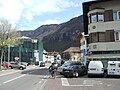
Auer town center

Auer station of the former Fiemme Valley Railway opposite the Brennerbahn station of the same name

Liberation Day Market (April 25th)
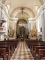
Interior of the Marienkirche

View of the Mitterberg
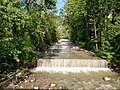
Schwarzenbach near the Schwarzenbach sports and recreation zone
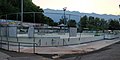
Schwarzenbach ice rink


.jpg)


Personalities
- Sepp Thaler (1901–1982), composer
literature
- Heinrich Lona: Auer in the South Tyrolean lowlands . Auer: Tourist Association 1977
- Helmut Zelger: Auer in the South Tyrolean lowlands. Interesting and worth knowing from the past and the present . Auer: Beautification Association 2006 (online)
- Käthe von Röggla: Bridge to my second home: Auer-Südtirol. Auer: Fotolito Varesco, edition 2002.
- Verkehrsverband Auer: Regional hiking guide for Auer, Aldein, Neumarkt, Montan, Truden, Altrei. Auer: Fotolito Varesco
Web links
- Website of the municipality of Auer
- Landscape plan of the municipality of Auer . Office for Landscape Ecology, Autonomous Province of Bolzano - South Tyrol (PDF file)
- History of Tyrol: Auer
- Entry in the Tirol Atlas of the Institute for Geography at the University of Innsbruck
Individual evidence
- ^ Egon Kühebacher: The place names of South Tyrol and their history. The historically grown names of the communities, parliamentary groups and hamlets . Athesia, Bozen 1991, ISBN 88-7014-634-0 , p. 41
- ^ A b Franz Huter (ed.), Hanns Bachmann: Handbook of historical sites . Band: Austria. Part 2: Alpine countries with South Tyrol (= Kröner's pocket edition . Volume 279). 2nd, revised edition. Kröner, Stuttgart 1978, ISBN 3-520-27902-9 , p. 561.
- ^ Hannes Obermair : Bozen Süd - Bolzano Nord. Written form and documentary tradition of the city of Bozen up to 1500 . tape 2 . City of Bozen, Bozen 2008, ISBN 978-88-901870-1-8 , p. 130, no. 1089a .
- ↑ Tobias Simonini: The Houses of God in Auer, 2016.
- ^ Georg Schraffl: St. Daniel on the Kiechlberg. In: Südtirol in Wort und Bild, Vol. 35, No. 3 (1991) pp. 6-7.
- ↑ The mayors of the South Tyrolean municipalities since 1952. (PDF; 15 MB) In: Festschrift 50 Years of the South Tyrolean Association of Municipalities 1954–2004. Association of South Tyrolean municipalities, pp. 139–159 , accessed on November 16, 2015 .
- ↑ Primary school district Auer. South Tyrolean Citizens' Network , accessed on October 26, 2014 .
- ↑ Technical college for agriculture and business school Auer. South Tyrolean Citizens' Network, accessed on October 26, 2014 .
- ↑ Unterland school district. South Tyrolean Citizens' Network, accessed on October 26, 2014 .

Abbey | Ahrntal | Aldein | Algund | Altrei | Andrian | Auer | Barbian | Bolzano | Branzoll | Burner | Brixen | Brunico | Burgstall | Corvara | Nova Ponente | Enneberg | Eppan | Feldthurns | Franzensfeste | Freienfeld | Gais | Gargazon | Glurns | Graun im Vinschgau | Casies | Avelengo | Innichen | Jenesien | Kaltern | Karneid | Kastelbell-Tschars | Castelrotto | Kiens | Klausen | Kuens | Kurtatsch | Kurtinig | Lasa | Laion | Lana | Laces | Laurein | Laives | Lüsen | Times | Margreid | Marling | Martell | Merano | Mölten | Montan | Moos in Passeier | Mühlbach | Mühlwald | Nals | Naturno | Naz-Sciaves | Neumarkt | Niederdorf | Olang | Partschins | Percha | Falzes | Pfatten | Pfitsch | Plausibility | Prad | Braies | Prettau | Proveis | Lawn Antholz | Ratschings | Riffian | Ritten | Rodeneck | Salurn | Sand in Taufers | Sarntal | Schenna | Schlanders | Schluderns | Schnals | Sexten | St. Christina in Val Gardena | St. Leonhard in Passeier | St. Lorenzen | St. Martin in Passeier | St. Martin in Thurn | St. Pankraz | Ortisei in Val Gardena | Sterzing | Stilfs | Taufers im Münstertal | Terenten | Terlan | Tiers | Tyrol | Tesimo | Toblach | Tramin | Truden | Tscherms | Ulten | Our Lady in the Walde-St. Felix | Vahrn | Villandro | Villnöß | Vintl | Fiè allo Sciliar | Verano | Waidbruck | Monguelfo Tesido | Welschnofen | Wengen | Selva in Val Gardena