Chambry (Aisne)
| Chambry | ||
|---|---|---|

|
|
|
| region | Hauts-de-France | |
| Department | Aisne | |
| Arrondissement | Laon | |
| Canton | Laon-1 | |
| Community association | Pays de Laon | |
| Coordinates | 49 ° 36 ' N , 3 ° 39' E | |
| height | 67-96 m | |
| surface | 8.89 km 2 | |
| Residents | 848 (January 1, 2017) | |
| Population density | 95 inhabitants / km 2 | |
| Post Code | 02000 | |
| INSEE code | 02157 | |
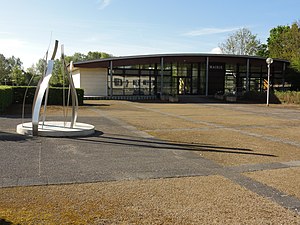
 Town hall (Mairie) of Chambry |
||
Chambry is a French municipality with 848 inhabitants (at January 1, 2017) in the department of Aisne in the region of Hauts-de-France (before 2016 Picardy ). It belongs to the Laon arrondissement , the Laon-1 canton ( Laon-Nord until 2015 ) and the Pays de Laon municipal association .
geography
The municipality is surrounded to the west by the prefecture of Laon , to the northwest and north by the municipality of Barenton-Bugny in the canton of Marle and by the neighboring municipalities of Samoussy in the northeast and Athies-sous-Laon in the east and southeast, which belong to the canton of Laon-2 . The Barentons River crosses the municipality.
Population development
| year | 1962 | 1968 | 1975 | 1982 | 1990 | 1999 | 2005 | 2015 |
| Residents | 415 | 406 | 534 | 749 | 709 | 785 | 781 | 831 |
| Source: Cassini and INSEE | ||||||||
Attractions
- Saint-Éloi church
Web links
Commons : Chambry - collection of images, videos and audio files

