
Chessy (Rhône)
| Chessy | ||
|---|---|---|
.svg)
|
|
|
| region | Auvergne-Rhône-Alpes | |
| Department | Rhône | |
| Arrondissement | Villefranche-sur-Saône | |
| Canton | Le Bois-d'Oingt | |
| Community association | Beaujolais Pierres Dorées | |
| Coordinates | 45 ° 53 ' N , 4 ° 37' E | |
| height | 211-342 m | |
| surface | 4.55 km 2 | |
| Residents | 2,063 (January 1, 2017) | |
| Population density | 453 inhabitants / km 2 | |
| Post Code | 69380 | |
| INSEE code | 69056 | |
| Website | http://www.chessy.mairies69.net/ | |
 Look at Chessy |
||

Chessy (also: Chessy-les-Mines ) is a French municipality with 2063 inhabitants (as of January 1 2017) in the department of Rhône in the region of Auvergne Rhône-Alpes . It belongs to the Arrondissement of Villefranche-sur-Saône , to the canton of Le Bois-d'Oingt and is a member of the Beaujolais Pierres Dorées community . The inhabitants are called Cassissiens .
geography
Chessy is located around 18 kilometers northwest of Lyon and around 19 kilometers south-southwest of Villefranche-sur-Saône in the Bourgogne am Azergues wine-growing region . Chessy is surrounded by the neighboring communities of Bagnols in the north, Châtillon in the east and southeast, Saint-Germain-Nuelles in the south and Le Breuil in the west.
history
Up until the recent past, copper and azurite were mined in Chessy .
Population development
| year | 1962 | 1968 | 1975 | 1982 | 1990 | 1999 | 2006 | 2012 |
| Residents | 878 | 942 | 977 | 1098 | 1262 | 1313 | 1509 | 1824 |
| Source: Cassini and INSEE | ||||||||
Attractions
- Nativité-de-Notre-Dame church
- Chessy Castle, Monument historique since 2004
- Courbeville Castle, Monument historique since 1926
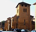
Nativité-de-Notre-Dame church

Chessy Castle

Courbeville Castle


