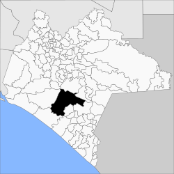
Municipio La Concordia (Chiapas)
| La Concordia | |
|---|---|

|
|
| Basic data | |
| Country | Mexico |
| State | Chiapas |
| Seat | La Concordia |
| surface | 2,580.7 km² |
| Residents | 44,082 (2010) |
| density | 17.1 inhabitants per km² |
| INEGI no. | 07020 |
| politics | |
| Presidente municipal | José Miguel Córdova García |
Coordinates: 16 ° 7 ′ N , 92 ° 41 ′ W
La Concordia is a municipality in the Mexican state of Chiapas . The municipality has about 44,000 inhabitants and is 2580.7 km² in size. The administrative seat and largest town of the municipality is La Concordia of the same name .
Part of the reservoir of the La Angostura dam and the El Triunfo biosphere reserve are located in the municipality .
geography
The municipality of La Concordia is located in the central south of the Mexican state Chiapas at heights between 400 m 2600 m . 81% of it belongs to the physiographic province of the Cordillera Centroamericana and 19% to the Sierra Madre de Chiapas ; a good 99% are in the hydrological region Grijalva - Usumacinta , around 0.8% are counted on the Costa de Chiapas . The geology of the municipality is 34% granite with 28% silty sandstone , 17% limestone and 9% alluvion ; The predominant soil types are Leptosol (42%), Acrisol (21%), Regosol (10%) and Cambisol (9%). About 55% of the community area is forested, 21% is used for arable farming, 18% is used for pasture land.
The municipality of La Concordia borders the municipality of Venustiano Carranza , Socoltenango , Chicomuselo , Ángel Albino Corzo , Mapastepec , Pijijiapan and Villa Corzo .
population
In the 2010 census, 44,082 people in 9,891 residential units were counted in the municipality. Of these, 2,765 people were registered as speakers of an indigenous language , including 1,446 speakers from Tzotzil and 974 speakers from Tzeltal . Over 23 percent of the population was illiterate. 14,637 inhabitants were registered as economically active, of which just under 88% were men and 2.2% were unemployed. A good 38% of the population lived in extreme poverty.
places
The municipality of La Concordia comprises 484 inhabited localidades , of which the main town as well as Benito Juárez and El Ámbar are classified as urban by the INEGI . In the 2010 census, 13 towns had a population of over 1000, 442 towns had fewer than 100 inhabitants. The biggest places are:
| place | Residents |
| La Concordia | 7641 |
| Benito Juarez | 2715 |
| El Ámbar ( El Ámbar de Echeverría ) | 2592 |
| La Tigrilla | 2346 |
| Diamante de Echeverría | 2157 |
| Dolores Jaltenango | 2090 |
| Independencia | 1953 |
| Plan de Agua Prieta | 1752 |
| Rizo de Oro | 1434 |
| Reforma | 1148 |
| Ignacio Zaragoza | 1127 |
| El Ramal ( Porvenir ) | 1054 |
| Nueva Libertad | 1005 |
| Nuevo Resplandor | 927 |
| Guadalupe Victoria | 851 |
| Niños Héroes | 805 |
Web links
- Enciclopedia de los Municipios y Delegaciones de México: Municipio La Concordia (Spanish)
- INEGI : Datos Geográficos: Municipio La Concordia (Spanish; PDF)
