Rocroi
| Rocroi | ||
|---|---|---|

|
|
|
| region | Grand Est | |
| Department | Ardennes | |
| Arrondissement | Charleville-Mezieres | |
| Canton | Rocroi | |
| Community association | Vallées and Plateau d'Ardenne | |
| Coordinates | 49 ° 56 ' N , 4 ° 31' E | |
| height | 121-391 m | |
| surface | 50.41 km 2 | |
| Residents | 2,330 (January 1, 2017) | |
| Population density | 46 inhabitants / km 2 | |
| Post Code | 08230 | |
| INSEE code | 08367 | |
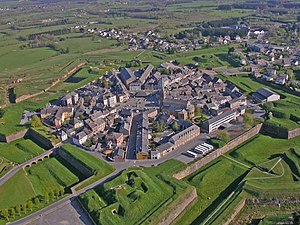
 Rocroi with the fortress |
||
Rocroi (also Rocroy ) is a French commune with 2330 inhabitants (as of January 1, 2017) in the Ardennes department in the Grand Est region . It belongs to the arrondissement of Charleville-Mézières .
geography
The municipality of Rocroi near the border with Belgium is 30 kilometers northwest of Charleville-Mézières , the prefecture of the Ardennes department .
The municipal area of over 50 km² extends from the left bank of the Meuse in the east to the watershed in the west, which leads to the catchment area of the Seine . The Rocroi fortress lies at 380 meters above sea level, almost at the highest point in the municipality. The Maas tributary Eau Noire rises north of Rocroi , to the southwest the Sormonne , which also drains to the Meuse, and west of the Oise tributary Gland .
Outside the fortress, the districts of La Croix de Fer and Hiraumont adjoin , other districts are Le Cheval Blanc and Le Grand Hangréau in the south and Saint-Nicolas on the Maas in the east.
Neighboring municipalities of Rocroi are Gué-d'Hossus and Couvin (Belgium) in the north, Fumay in the northeast, Revin in the east, Les Mazures in the southeast, Bourg-Fidèle and Le Châtelet-sur-Sormonne in the south, Sévigny-la-Forêt in the southwest as well as waist in the west.
history
In order to be able to withstand the power of Charles V , the French King Henry II had Rocroi expanded into a fortress. As it is today, the community was then located on the border, at that time still to the Holy Roman Empire of the German Nation .
The Battle of Rocroi took place south of the city in 1643 as part of a long war between the French and the Spanish. Despite the majority of Spanish troops, the Duke of Enghien , also known as the Grand Condé , managed to deal a devastating blow to the Spaniards.
In 1653 the Spaniards managed to occupy Rocroi and hold it for a period of six years. During this time, the fortifications were further expanded.
The famous fortress builder Vauban had the town of Rocroi expanded and protected in 1675 in such a way that it received a five-pointed fortress wall in the shape of a star, which was a typical rampart for the time. Vauban created two entrances to the city: In the northeast the Porte de Bourgogne and in the southwest the Porte de France . The then French King Louis XIV stipulated that the Champagne would be protected against enemy troops in the future.
During the Franco-Prussian War , the fortress was taken in a coup on January 5, 1871, after five hours of fighting by Prussian troops under Major General Schuler von Senden .
Population development
| year | 1962 | 1968 | 1975 | 1982 | 1990 | 1999 | 2004 | 2009 | 2014 |
|---|---|---|---|---|---|---|---|---|---|
| Residents | 2870 | 2997 | 2911 | 2789 | 2555 | 2420 | 2379 | 2397 | 2377 |
| Source: Cassini and INSEE | |||||||||
Personalities
- Henri Canard (1824-1894), governor of Senegal
- Arthur Chuquet (1853-1925), historian
- Chéri Hérouard (1881–1961), illustrator
- Anne Pierre Nicolas de Lapisse (1773–1850), officer
- Jean René Moreaux (1758–1795), General de division
- Auguste Warnier (1810–1875), politician
Web links
Individual evidence
- ^ Hermann Ludwig von Wartensleben: The operations of the First Army under General Manteuffel. Berlin 1873, p. 168.


