
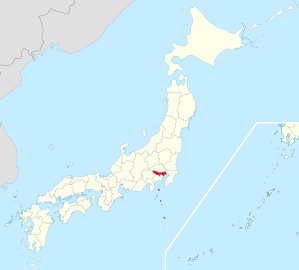
Tokyo prefecture
|
Tōkyō-to 東京 都 |
|
|---|---|
  |
|
| Basic data | |
| Administrative headquarters : | Shinjuku , Tokyo |
| Region : | Kanto |
| Main island : | Honshu |
| Area : | 2,194.07 km² |
| Water content: | 1 % |
| Residents : | 13,942,856 (October 1, 2019) |
| Population density : | 6355 inhabitants per km² |
| Counties : | 1 |
| Municipalities : | 39 + 23 districts of Tokyo |
| ISO 3166-2 : | JP-13 |
| Governor : | Yuriko Koike |
| Website: | www.metro.tokyo.jp |
| Symbols | |
| Prefecture flag : |
 |
| Prefecture tree : | ginkgo |
| Prefecture flower : | Yoshino cherry blossom |
| Vogel prefecture : | Black-headed gull |
| Prefecture song : |
Tōkyō-shika / Tōkyō-toka ("Song of the City of Tōkyō" / "Song of the Prefecture of Tōkyō") |
| Citizens Day: | October 1 |
The Tokyo Prefecture ( Japanese 東京 都 Tōkyō-to , English Tokyo Prefecture or in its own name Tokyo Metropolis , often just Tokyo ) is one of the prefectures of Japan and is mostly in the Kantō plain . With over 13 million inhabitants, it is the most populous prefecture in Japan , but at only 2,000 km² it is also the third smallest. The seat of the prefecture administration is the [special] district Shinjuku , even if for geographic purposes, e.g. On state maps, for example, the whole of Tokyo is often still regarded as the prefecture capital, although it was abolished as an administrative unit in 1943.
geography

The 23 districts ( 区 , ku ) in the eastern part form the urban core area of Tokyo with a total area of around 621 km² and over 9 million inhabitants (as of May 2015) .
In the middle part, other large cities join seamlessly. Hachiōji alone , the largest of them, has over half a million inhabitants. The western part, on the other hand, lies on the foothills of the Japanese Alps , is only sparsely populated and with its mountainous landscape is scenic (including around Lake Okutama ). The highest point of the prefecture is the summit of Kumotoriyama (2017.1 m) on the border with the prefectures of Saitama and Yamanashi . The central and western part is also known collectively as the Tama area and has over 4 million inhabitants on 1,169 km².
The west is drained by the Tamagawa , on its lower reaches the river forms the southern border of Tokyo to Kanagawa. The great importance that had the Tamagawa historically for the water supply of the city of Edo / Tokyo was a major reason for the annexation of the Tama area 1893. In the districts in the east, there are some short rivers that directly into the Tokyo Bay lead and are partially connected to the Arakawa system by the moats and canals of the Tokugawa. In the far east and north, the Arakawa [drainage canal] , built in the early 20th century, and the Sumidagawa (the previous lower reaches of the Arakawa from the 17th to the 20th centuries) collect most of the rivers. The eastern border between Tokyo and Chiba is formed by today's Edogawa (in the 17th century, during the diversion measures of the Tokugawa for flood protection, the lower reaches of the Tonegawa , before that, originally called Ōigawa or Futoigawa, the lower reaches of the Watarasegawa to the east of the Tonegawa ) and its current estuary, the Kyū- Edogawa ("Old / Ex-Edogawa"). The northern border to Saitama in the Kantō plain is only partially marked by rivers. In the west, a ridge of the Kantō Mountains partially forms the border to Yamanashi and Kanagawa and at the same time the watershed between Tamagawa and Sagamigawa . In the far northwest, mountain ridges to the left of the Tamagawa form the boundaries to Yamanashi and Saitama.
After all, Tokyo prefecture also includes more than 60 small islands in the Pacific south of Honshū . 20 of them belong to the Izu Islands , of which the northernmost, Izu-Ōshima , is also the largest. To the south of this are the Ogasawara Islands , more than 1,000 km from the Kantō plain, which can only be reached by a 24-hour boat trip. They have been a UNESCO World Heritage Site since 2011. While the main part of the prefecture belongs to the temperate climate zone , the Ogasawara Islands are already in the subtropics . With the islands of Okinotorishima and Minami-Torishima , the southernmost and easternmost parts of the Japanese national territory also belong to the Tokyo Prefecture.
The Chichibu-Tama-Kai , Fuji-Hakone-Izu and Ogasawara National Parks as well as the Meiji-no-Mori-Takao-Quasi-National Park are partly or entirely in the prefecture . There are also six prefectural nature parks (toritsu shizen kōen) in Tokyo .
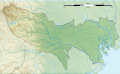
Topographic map of the contiguous part of Tokyo Prefecture on the main island of Honshu
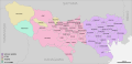
Graphic of Tokyo Prefecture with the districts (purple) and cities and towns (pink and brown) excluding the Izu and Ogasawara Islands .


history

The Tokyo Prefecture was set up in the Meiji Restoration in 1868, initially for a short time as Edo Prefecture, Edo-fu , and then as Tōkyō-fu ( 東京 府 ) after the renaming of Edo in Tokyo in the same year . In contrast to most of the other prefectures, which were established as ken , nine urban areas, which had been administered by Bugyō directly from the Shogun , were set up as fu . These included the capitals of Edo, Kyōto and Osaka, and initially also the contractual ports opened in the unequal treaties . The latter were converted to Ken in 1869 .

The territory of the prefecture initially corresponded to that of the later city of Tokyo. After the abolition of the fief system ( Han ) and the extensive division of Japan into prefectures in 1871, the prefectures Kosuge and Shinagawa as well as parts of Ōmiya / Urawa were added to Tokyo, which thus encompassed the later districts of Ebara , East Tama and South Toshima (1896 to Toyotama United), North Toshima , South Adachi, and South Katsushika . Other areas followed: the Izu Islands of Shizuoka in 1878 , the Ogasawara Islands in 1880 and the three western parts of Tama County of Kanagawa in 1893 . As a result, rural regions and remote islands also belonged to Tokyo.
In 1878 a prefecture parliament (fukai) with 49 members was elected for the first time . In 1889, the government subdivided the prefectures into the municipal forms that still exist today: the [district] city of Tōkyō was established in the area of the Tokyo prefecture and cities ( Machi ) and villages ( Mura ) in the surrounding districts . However, the governor of the prefecture appointed by the Ministry of the Interior remained mayor of the city of Tokyo - a regulation that initially applied to all "three capitals" (santo) , that is, in addition to Tōkyō, also for the cities of Kyoto and Osaka . It was not until October 1, 1898, that the city of Tokyo received an administration that was independent of the prefecture administration of Tokyo and thus a self-government, albeit limited from a post-war perspective. In 1922, the city of Tokyo declared October 1st a "self -government commemoration day " (jichi-kinenbi) - under the same name it still exists in the city of Kyoto, which still exists today, but where the independent city administration was not established until October 15, 1898. After the post-war reforms, with which the prefecture and the municipalities in Tokyo also received a significantly expanded self-government, the prefecture declared in 1952 as successor to both the prefecture (-fu) and the city (-shi) Tokyo, October 1st in a prefectural statute "Day of the Prefectural Citizens " ( 都 民 の 日 , tomin no hi ).
1943 were dissolved with the Tōkyō-tosei city and previous Tokyo prefecture and the capital city Tōkyō-to established. The mayors of the Tokyo districts were now directly subordinate to the Tokyo Prefecture and the governor was called tōkyō-to-chōkan ( 東京 都 長官 ). After the end of the Pacific War , the administration was democratized, as in the other prefectures: from 1947 the governor was elected by the people. However, the special status of the former urban area of Tokyo was partially retained, but the districts were given greater autonomy and now have largely the same rights as the other municipalities in the country.
The second independent city (shi) in the prefecture was Hachiōji in 1917, followed by Tachikawa in 1940 - after the dissolution of the city of Tokyo in 1943 the only two shi in Tokyo. Starting with Musashino in 1947, a large part of the prefecture was organized in independent cities in the post-war years. Of the three Tama districts, only one still exists today, which since 1995 has consisted of four no longer connected communities.
population


As of July 1, 2011, Tokyo Prefecture had 13,190,383 residents (6,547,551 men and 6,642,832 women) who lived in 6,445,202 households. Only 3.1% of the total population (410,184) are registered foreigners.
Population development in the prefecture
| Census year |
Total population |
male population |
female population |
Gender ratio men to 1000 women |
Area in km² |
Population density per km 2 |
|---|---|---|---|---|---|---|
| 1920 | 3,699,428 | 1,952,989 | 1,746,439 | 1118 | 2142.40 | 1726.8 |
| 1925 | 4,485,144 | 2,387,609 | 2,097,535 | 1138 | 2142.40 | 2093.5 |
| 1930 | 5,408,678 | 2,855,323 | 2,553,355 | 1118 | 2144.79 | 2521.8 |
| 1935 | 6,369,919 | 3,325,696 | 3,044,223 | 1093 | 2144.80 | 2969.9 |
| 1940 | 7,354,971 | 3,795,875 | 3,559,096 | 1067 | 2144.80 | 3429.2 |
| 1945 | 3,488,284 | 1,788,145 | 1,700,139 | 1052 | 2148.00 | 1624.0 |
| 1950 | 6.277.500 | 3,169,389 | 3.108.111 | 1020 | 2137.26 | 2937.2 |
| 1955 | 8,037,084 | 4,115,823 | 3,921,261 | 1050 | 2129.15 | 3774.8 |
| 1960 | 9,683,802 | 4,997,023 | 4,686,779 | 1066 | 2133.03 | 4539.9 |
| 1965 | 10,869,244 | 5,564,583 | 5,304,661 | 1049 | 2135.11 | 5090.7 |
| 1970 | 11,408,071 | 5,801,009 | 5,607,062 | 1035 | 2141.11 | 5328.1 |
| 1975 | 11,673,554 | 5,913,373 | 5,760,181 | 1027 | 2145.38 | 5441.3 |
| 1980 | 11,618,281 | 5,856,280 | 5,762,001 | 1016 | 2156.35 | 5387.9 |
| 1985 | 11,829,363 | 5,955,029 | 5,874,334 | 1014 | 2162.34 | 5470.6 |
| 1990 | 11,855,563 | 5,969,773 | 5,885,790 | 1014 | 2183.26 | 5430.2 |
| 1995 | 11,773,605 | 5,892,704 | 5,880,901 | 1002 | 2186.62 | 5384.4 |
| 2000 | 12.064.101 | 6,028,562 | 6,035,539 | 999 | 2186.90 | 5516.5 |
| 2005 | 12,576,601 | 6,264,895 | 6.311.706 | 993 | 2186.96 | 5750.7 |
| 2010 | 13,159,388 | 6,512,110 | 6,647,278 | 980 | 2187.50 | 6015.7 |
| 2015 | 13,515,271 | 6,666,690 | 6,848,581 | 973 | 2190.93 | 6168.7 |
economy
.jpg)

The “ gross domestic product ” of Tokyo prefecture amounted to 92.3 trillion yen (around 590 billion euros) in fiscal year 2006 , which corresponds to almost a fifth of the total Japanese domestic product.
Services play the main role in Tokyo's economy: of the approximately 8.7 million employees in Tokyo in 2006 - including more than 7.2 million in the 23 districts - fewer than 1.4 million were in industry, construction, energy, Gas and water supply and only a good 6,000 active in mining, agriculture, forestry and fishing. The corporate headquarters of numerous Japanese companies and many branches of foreign companies are located in Tokyo. The Tokyo Stock Exchange is the largest in Japan and Tokyo is one of the most important financial centers in Asia and the world.
Income and the cost of living in Tokyo are high. The average monthly household income (employees only) in Tokyo in 2006 was around 570,000 yen, of which around 428,000 yen was spent on living expenses.
The minimum wage in Tokyo is currently (October 1, 2019 - October 2020) 1013 yen, the highest of all 47 prefectures.
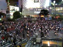
Cityscape
Architecture in Tokyo has largely been shaped by the history of Tokyo. Twice in recent history, the metropolis has been left in ruins: first in the Great Kanto earthquake in 1923 and later after a comprehensive incendiary attack on Tokyo in World War II. Because of this, Tokyo's urban landscape consists mostly of modern and contemporary architecture, and older buildings are rare. Tokyo is home to many internationally known forms of modern architecture , including the Tokyo International Forum , Asahi Beer Hall , Mode Gakuen Cocoon Tower , NTT Docomo Yoyogi Building, and Rainbow Bridge . Tokyo also features two distinctive towers: Tokyo Tower and the new Tokyo Skytree , which is the tallest tower in Japan and the world, and the second tallest structure in the world after the Burj Khalifa in Dubai. Mori Building Co has started work on Tokyo's new tallest building, due for completion in March 2023. The project will cost 580 billion yen ($ 5.5 billion).
Tokyo also contains numerous parks and gardens in Tokyo . There are four national parks in Tokyo Prefecture, including Fuji Hakone Izu National Park , which includes all of the Izu Islands .
.JPG)
Politics and administration


At the head of the prefectural administration of Tokyo ( Tōkyō tochō ; English Tokyo Metropolitan Government , TMG) is the governor ( 東京 都 知事 , Tōkyō tochiji ) as in all prefectures . In the 2016 gubernatorial election in Tokyo , the former LDP deputy and minister, Yuriko Koike, was elected to succeed Yōichi Masuzoe , who resigned due to an expense scandal . Koike had declared her candidacy before and as a result against the LDP's nomination process and in 2017 founded her own prefectural party, the Tomin First no Kai . In the 2020 gubernatorial election , according to the 8 p.m. forecast of the public broadcaster NHK , she won a second term with a clear majority against the center-left candidate Kenji Utsunomiya and 20 other applicants.
The Tokyo Prefectural Parliament ( Tōkyō togikai ) has 127 members and is responsible for the legislature and the budget. It also votes on important governor personnel decisions, including the lieutenant governors. Since the last election on July 2, 2017 , Koikes Tomin First no Kai has been the strongest force, but has since lost several MPs and the Kōmeitō as permanent allies. The LDP, the strongest and declared prefecture “opposition” party before the 2017 election, recorded its historically worst result with 23 seats. The Japanese Communist Party is the fourth largest force.
The Tokyo Prefecture assumes certain administrative tasks from the 23 districts that the municipalities are entitled to in other prefectures or other municipalities in Tokyo. This includes public services such as the fire brigade and infrastructure areas such as water supply. For this purpose, it receives some of the municipal taxes from the districts and in turn allocates funds to these according to their population. In the post-war decades, many of the cities and towns to the west of the districts also transferred responsibility for fire brigade and water supply to the prefecture: Today, with only a few exceptions, the Tokyo water supply authority and fire brigade are responsible for the entire main island part of Tokyo. The Izu and Ogasawara Islands are administered by four sub-prefectures , which are located at the Department of General Affairs (sōmu-kyoku) .
The prefecture elects 25 Shūgiin MPs directly to the national parliament - after the 2017 election and party reshuffles since then (as of August 2019) 20 Liberal Democrats, one Kōmeitō member and four Constitutional Democrats - and six Sangiin MPs per partial election, after the 2016 , 2019 elections and party reshuffles since then : four Liberal Democrats, three Constitutional Democrats, two members each from Kōmeitō and KPJ and one from Nippon Ishin no Kai .
The Tokyo Police, which for historical reasons is called Keishi-chō and not Tokyo Prefectural Police (which is translated into English but analogously to the other 46), is by far the largest police force in Japan with over 40,000 police officers.
CO 2 emissions trading
In the fiscal year 2010, a mandatory program for emissions trading for industry and offices began in Tokyo Prefecture on April 1, 2010 . In the period 2010 to 2014, greenhouse gas emissions should then be reduced by six to eight percent, by the end of fiscal year 2019 (April 2020) by 15-17%, and by fiscal year 2024 by 25-27%. In 2011, emissions trading began in the neighboring prefecture of Saitama , which was linked to the Tokyo system.
International partnerships
Although the prefecture of Tokyo is not a city, it maintains both (quasi as a representative of the non-existent city of Tokyo ) numerous twinnings with world cities , as well as regional partnerships . In addition, the capital districts and cities in the region also maintain their own city partnerships.
In addition to the twelve bilateral city and regional partnerships, the Tokyo Prefecture is part of the ANMC21 (Asian Network of Major Cities 21) , a cooperation between Asian capitals and capital regions . This includes a political cooperation with the Greater London Authority that was agreed in 2006. Since then, Tokyo Prefecture has also been a member of the C40 Large Cities Climate Leadership Group initiated by Greater London in 2005 .
Town twinning
-
 Berlin , Germany (since 1994)
 -
 Jakarta , Indonesia (since 1989)
 -
 Cairo , Egypt (since 1990)
 -
 Moscow , Russia (since 1991)
 -
 New York , USA (since 1960)
 -
 Paris , France (since 1982)
 -
 Beijing , People's Republic of China (since 1979)
 -
 Rome , Italy (since 1996)
 -
 Seoul , South Korea (since 1988)
 -
 London , United Kingdom (since 2015)
Regional partnerships
-
 New South Wales , Australia (since 1984)
 -
 São Paulo , Brazil (since 1990)
Administrative division


Since 2001 there are still 62 parishes in Tokyo (in 1893 there were more than 150 and in 1953 just under 100, see list of former parishes in Tokyo prefecture ):
- 23 (special) districts ( [tokubetsu] -ku ) ,
- 26 [independent] cities (- shi ) , including Hachiōji , a " core city " since April 2015 ,
- 5 cities (- machi ) and
- 8 villages (- mura ) .
The machi and mura on the islands in Tokyo have the peculiarity that they never belonged to one of the districts (- gun ) - abolished as an administrative unit in the 20th century, but still used as a geographical unit today - but rather by sub-prefectures (- shichō) are more closely tied to the prefecture administration to this day.
At the beginning of the following table are the 23 special districts ( 特別 区 , -tokubetsuku ), followed by the urban districts ( 市 , -shi ). At the end of the table, the single district ( 郡 , -gun ) and the four sub-prefectures ( 支 庁 , -shichō ) are shown in italics, below (indented) the small towns ( 町 , -machi ) and villages ( 村 , -mura ) within them .
|
code |
Surname | Area (in km²) | population | Population density ( inhabitants / km²) 2 |
||
|---|---|---|---|---|---|---|
| Rōmaji | Kanji | January 1, 2020 | 1st October 2019 | October 1, 2015 | ||
| 13101 | Chiyoda- ku | 千代 田 区 | 11.66 | 65,472 | 58,406 | 5417.2 |
| 13102 | Chūō- ku | 中央 区 | 10.21 | 166,536 | 141.183 | 15,758.0 |
| 13103 | Minato- ku | 港区 | 20.37 | 259.494 | 243.283 | 12,587.9 |
| 13104 | Shinjuku- ku | 新宿 区 | 18.22 | 349,511 | 333,560 | 19,042.7 |
| 13105 | Bunkyō- ku | 文 京 区 | 11.29 | 235.026 | 219.724 | 20,388.3 |
| 13106 | Taitō- ku | 台 東区 | 10.11 | 208,562 | 198.073 | 20,342.1 |
| 13107 | Sumida- ku | 墨 田 区 | 13.77 | 269,627 | 256.274 | 19,361.3 |
| 13108 | Kōtō -ku | 江東 区 | 40.16 | 518.371 | 498.109 | 12,824.4 |
| 13109 | Shinagawa- ku | 品 川 区 | 22.84 | 411.070 | 386,855 | 17,659.3 |
| 13110 | Meguro -ku | 目 黒 区 | 14.67 | 287,776 | 277,622 | 19,434.9 |
| 13111 | Ōta -ku | 大田 区 | 60.83 | 739.962 | 717.082 | 12,072.7 |
| 13112 | Setagaya- ku | 世 田 谷 区 | 58.05 | 938.205 | 903.346 | 16,011.2 |
| 13113 | Shibuya- ku | 渋 谷 区 | 15.11 | 234,728 | 224,533 | 15,334.2 |
| 13114 | Nakano- ku | 中 野 区 | 15.59 | 341.985 | 328.215 | 21,685.0 |
| 13115 | Suginami- ku | 杉 並 区 | 34.06 | 585.186 | 563.997 | 17,025.2 |
| 13116 | Toshima- ku | 豊 島 区 | 13.01 | 300,756 | 291.167 | 23,072.9 |
| 13117 | Kita -ku | 北区 | 20.61 | 354.256 | 341.076 | 17,062.7 |
| 13118 | Arakawa- ku | 荒 川 区 | 10.16 | 218.434 | 212.264 | 21,384.4 |
| 13119 | Itabashi- ku | 板橋 区 | 32.22 | 583,467 | 561.916 | 17,943.1 |
| 13120 | Nerima- ku | 練 馬 区 | 48.08 | 741,649 | 721.722 | 15,291.4 |
| 13121 | Adachi- ku | 足 立 区 | 53.25 | 683.110 | 670.122 | 12,775.0 |
| 13122 | Katsushika- ku | 葛 飾 区 | 43.8 | 454,882 | 442.913 | 13,010.4 |
| 13123 | Edogawa- ku | 江 戸 川 区 | 49.9 | 696.014 | 681.298 | 13,900.1 |
| 13201 | Hachiōji- shi | 八 王子 市 | 186.38 | 577,560 | 577,513 | 3097.2 |
| 13202 | Tachikawa- shi | 立 川 市 | 24.36 | 180,880 | 176.295 | 7398.0 |
| 13203 | Musashino- shi | 武 蔵 野 市 | 10.98 | 148,326 | 144,730 | 13,443.3 |
| 13204 | Mitaka- shi | 三 鷹 市 | 16.42 | 192.489 | 186.936 | 11,657.0 |
| 13205 | Ōme -shi | 青梅 市 | 103.31 | 133,824 | 137.381 | 1305.4 |
| 13206 | Fuchsu- shi | 府中 市 | 29.43 | 263,932 | 260.274 | 8964.8 |
| 13207 | Akishima -shi | 昭 島 市 | 17.34 | 112.005 | 111,539 | 6455.7 |
| 13208 | Chofu- shi | 調 布 市 | 21.58 | 239,650 | 229.061 | 11,011.9 |
| 13209 | Machida- shi | 町 田 市 | 71.55 | 434,407 | 432,348 | 6064.8 |
| 13210 | Koganei- shi | 小 金井 市 | 11.3 | 125,815 | 121,396 | 11,036.5 |
| 13211 | Kodaira- shi | 小平 市 | 20.51 | 196.137 | 190.005 | 9495.7 |
| 13212 | Hino- shi | 日 野 市 | 27.55 | 189,945 | 186.283 | 6859.9 |
| 13213 | Higashimurayama- shi | 東村 山 市 | 17.14 | 150.186 | 149,956 | 8757.4 |
| 13214 | Kokubunji- shi | 国 分 寺 市 | 11.46 | 127,790 | 122,742 | 11,022.4 |
| 13215 | Kunitachi- shi | 国立 市 | 8.15 | 75,156 | 73,655 | 9205.2 |
| 13218 | Fussa- shi | 福 生 市 | 10.16 | 57,527 | 58,395 | 5726.8 |
| 13219 | Coma- shi | 狛 江 市 | 6.39 | 83,788 | 80,249 | 12,989.5 |
| 13220 | Higashiyamato- shi | 東 大 和 市 | 13.42 | 84.223 | 85.157 | 6295.1 |
| 13221 | Kiyose- shi | 清 瀬 市 | 10.23 | 75,190 | 74,864 | 7370.5 |
| 13222 | Higashikurume -shi | 東 久留 米 市 | 12.88 | 116,482 | 116,632 | 9030.2 |
| 13223 | Musashimurayama- shi | 武 蔵 村 山 市 | 15.32 | 71,579 | 71,229 | 4687.0 |
| 13224 | Tama- shi | 多 摩 市 | 21.01 | 147.832 | 146.631 | 7035.8 |
| 13225 | Inagi- shi | 稲 城市 | 17.97 | 91,649 | 87,636 | 5051.4 |
| 13227 | Hamura- shi | 羽 村 市 | 9.9 | 54,874 | 55,833 | 5556.0 |
| 13228 | Akiruno- shi | あ き る 野 市 | 73.47 | 80,074 | 80,954 | 1092.2 |
| 13229 | Nishitōkyō- shi | 西 東京 市 | 15.75 | 205.801 | 200.012 | 12,905.3 |
| 13300 | Nishitama-gun (West Tama County ) | 西多摩 郡 | 375.86 | 58,334 | 152.2 | |
| 13303 | Mizuho- machi | 瑞 穂 町 | 16.85 | 32,478 | 33,445 | 1950.6 |
| 13305 | Hinode- machi | 日 の 出 町 | 28.07 | 17.191 | 17,446 | 613.7 |
| 13307 | Hinohara- mura | 檜 原 村 | 105.41 | 2012 | 2209 | 19.7 |
| 13308 | Okutama-machi | 奥多摩 町 | 225.53 | 4913 | 5234 | 22.3 |
| 13360 | Ōshima-shichō ( shima sub-prefecture ) | 大 島 支 庁 | 141 | 12,861 | 87.1 | |
| 13361 | Ōshima-machi | 大 島 町 | 90.76 | 7268 | 7884 | 82.1 |
| 13362 | Toshima-mura | 利 島村 | 4.12 | 343 | 337 | 84.2 |
| 13363 | Niijima-mura | 新 島村 | 27.54 | 2611 | 2749 | 95.6 |
| 13364 | Kozushima-mura | 神 津 島村 | 18.58 | 1861 | 1891 | 99.4 |
| 13380 | Miyake-shichō ( Ogasawara Sub-Prefecture ) | 三 宅 支 庁 | 75.8 | 2817 | 35.5 | |
| 13381 | Miyake-mura | 三 宅村 | 55.26 | 2292 | 2482 | 42.5 |
| 13382 | Mikurajima-mura | 御 蔵 島村 | 20.54 | 338 | 335 | 16.6 |
| 13400 | Hachijō-shichō ( Hachijō Sub-Prefecture ) | 八丈 支 庁 | 83.01 | 7791 | 89.4 | |
| 13401 | Hachijō-machi | 八丈 町 | 72.23 | 7127 | 7613 | 100.4 |
| 13402 | Aogashima- mura | 青 ヶ 島村 | 5.96 | 175 | 178 | 28.4 |
| 13420 | Ogasawara-shichō ( Ogasawara Sub-Prefecture ) | 小 笠原 支 庁 | 106.88 | 3022 | 28.5 | |
| 13421 | Ogasawara- mura | 小 笠原 村 | 106.88 | 3047 | 3022 | 28.5 |
| Unclear municipality affiliation (but in the sub-total districts) | 8.60 | |||||
| Unclear municipality affiliation (but sub-prefectures in the subtotal) | 4.81 | |||||
| Tokubetsuku -bu (proportion of the "special" districts, " Tokyo ", formerly the city of Tokyo ) | 特別 区 部 | 627.57 | 9,272,740 | 15,226.9 | ||
| Shi-bu (proportion of urban districts) | 市 部 | 783.95 | 4,157,706 | 5363.7 | ||
| shicho-, gun-bu (proportion of sub-prefectures and counties) | 支 庁 ・ 郡 部 | 782.55 | 84,825 | 105.6 | ||
| 13000 | Tōkyō-to (Tokyo Prefecture) | 東京 都 | 2,194.07 | 13,942,856 | 13,515,271 | 6309.8 |
There are also areas of unexplained parish membership on the Saitama and Chiba prefectural borders.
Biggest places
| place | Census year | Remarks | |||||
|---|---|---|---|---|---|---|---|
| 2015 | 2010 | 2005 | 2000 | 1995 | 1990 | ||
| Chiyoda-ku | 58,406 | 47,115 | 41,778 | 36,035 | 34,780 | 39,472 | |
| Chūō-ku | 141.183 | 122,762 | 98,399 | 72,526 | 63,923 | 68,041 | |
| Minato-ku | 243.283 | 205.131 | 185.861 | 159,398 | 144,885 | 158,499 | |
| Shinjuku-ku | 333,560 | 326,309 | 305.716 | 286.726 | 279.048 | 296,790 | |
| Bunkyō-ku | 219.724 | 206,626 | 189,632 | 176.017 | 172.474 | 181.269 | |
| Taitō-ku | 198.073 | 175.928 | 165.186 | 156.325 | 153.918 | 162,969 | |
| Sumida-ku | 256.274 | 247,606 | 231.173 | 215.979 | 215,681 | 222,944 | |
| Kōtō-ku | 498.109 | 460,819 | 420,845 | 376.840 | 365.604 | 385.159 | |
| Shinagawa-ku | 386,855 | 365.302 | 346.357 | 324,608 | 325,377 | 344,611 | |
| Meguro-ku | 277,622 | 268,330 | 264.064 | 250.140 | 243,100 | 251.222 | |
| Ōta-ku | 717.082 | 693.373 | 665.674 | 650.331 | 636.276 | 647.914 | |
| Setagaya-ku | 903.346 | 877.138 | 841.165 | 814.901 | 781.104 | 789.051 | |
| Shibuya-ku | 224,533 | 204,492 | 203,334 | 196,682 | 188,472 | 205,625 | |
| Nakano-ku | 328.215 | 314,750 | 310,627 | 309,526 | 306,581 | 319,687 | |
| Suginami-ku | 563.997 | 549,569 | 528.587 | 522.103 | 515,803 | 529.485 | |
| Toshima-ku | 291.167 | 284,678 | 250,585 | 249.017 | 246.252 | 261,870 | |
| Kita-ku | 341.076 | 335,544 | 330.412 | 326.764 | 334.127 | 354,647 | |
| Arakawa-ku | 212.264 | 203.296 | 191.207 | 180,468 | 176,886 | 184,809 | |
| Itabashi-ku | 561.916 | 535.824 | 523.083 | 513,575 | 511.415 | 518.943 | |
| Nerima-ku | 721.722 | 716.124 | 692,339 | 658.132 | 635.746 | 618.663 | |
| Adachi-ku | 670.122 | 683.426 | 624,807 | 617.123 | 622.270 | 631.163 | |
| Katsushika-ku | 442.913 | 442,586 | 424,878 | 421,519 | 424.478 | 424,801 | |
| Edogawa-ku | 681.298 | 678.967 | 653.944 | 619.953 | 589.414 | 565,939 | |
| Hachiōji | 577,513 | 580.053 | 560.012 | 536.046 | 503.363 | 466.347 | |
| Tachikawa | 176.295 | 179,668 | 172,566 | 164,709 | 157.884 | 152.824 | |
| Musashino | 144,730 | 138,734 | 137,525 | 135,746 | 135.051 | 139,077 | |
| Mitaka | 186.936 | 186.083 | 177.016 | 171,612 | 165.721 | 165,564 | |
| Ōme | 137.381 | 139,339 | 142.354 | 141.394 | 137.234 | 125,960 | |
| Foxu | 260.274 | 255.506 | 245,623 | 226,769 | 216.211 | 209.396 | |
| Akishima | 111,539 | 112.297 | 110.143 | 106,532 | 107.292 | 105,372 | |
| Chofu | 229.061 | 223,593 | 216.119 | 204,759 | 198,574 | 197,677 | |
| Machida | 432,348 | 426.987 | 405,534 | 377.494 | 360.525 | 349.050 | |
| Koganei | 121,396 | 118,852 | 114.112 | 111,825 | 109.279 | 105,899 | |
| Kodaira | 190.005 | 187.035 | 183,796 | 178,623 | 172.946 | 164.013 | |
| Hino | 186.283 | 180.052 | 176,538 | 167.942 | 166,537 | 165.928 | |
| Higashimurayama | 149,956 | 153,557 | 144.929 | 142,290 | 135.112 | 134.002 | |
| Kokubunji | 122,742 | 120,650 | 117,604 | 111,404 | 105,786 | 100,982 | |
| Kunitachi | 73,655 | 75,510 | 72,667 | 72.187 | 66,719 | 65,833 | |
| Tanashi | - | - | - | 78.165 | 74,813 | 75.144 | |
| Hōya | - | - | - | 102,720 | 100,260 | 95,146 | |
| Fussa | 58,395 | 59,796 | 61,074 | 61,427 | 61,497 | 58,062 | |
| Coma | 80,249 | 78,751 | 78,319 | 75,711 | 74,656 | 74,189 | |
| Higashiyamato 1 | 85.157 | 83,068 | 79,353 | 77,212 | 76,355 | 75,132 | Yamato-machi |
| Kiyose | 74,864 | 74,104 | 73,529 | 68,037 | 67,386 | 67,539 | |
| Higashikurume 1 | 116,632 | 116,546 | 115,330 | 113,302 | 111.097 | 113,818 | Kurume-machi |
| Musashimurayama 1 | 71,229 | 70.053 | 66,553 | 66.052 | 67.015 | 65,562 | Murayama-machi |
| Tama | 146.631 | 147,648 | 145,877 | 145,862 | 148.113 | 144,489 | |
| Inagi | 87,636 | 84,835 | 76,492 | 69,235 | 62,806 | 58,635 | |
| Akigawa | - | - | - | - | - | 50,387 | |
| Hamura | 55,833 | 57.032 | 56,514 | 56.013 | 55,095 | - | |
| Akiruno | 80,954 | 80,868 | 79,587 | 78.351 | 75,355 | - | |
| Nishitōkyō | 200.012 | 196.511 | 189,735 | - | - | - | |
Remarks:
- In 1970 six small towns were raised to urban districts, including the 1 marked with a name change at the same time.
- November 1, 1991 - The small town of Hamura -cho is raised to the status of a district-free town .
- September 1, 1995 - The independent city of Akigawa and a municipality unite to form the new (independent) city of Akiruno .
- January 21, 2001 - The independent cities of Hōya and Tanashi are united to form the new (independent) city of Nishi-Tōkyō .
See also
Web links
- Official website of the Prefecture Administration (Japanese, English, Chinese, Korean)
Individual evidence
- ↑ Tokyo Prefecture Administration , Political Planning Bureau, General Affairs Department: 東京 都 庁 の 所在地
- ↑ Tokyo Prefecture Administration, Environment Agency (kankyō-kyoku) : Nature parks in Tokyo Prefecture ( Memento of the original from July 27, 2016 in the Internet Archive ) Info: The archive link was inserted automatically and has not yet been checked. Please check the original and archive link according to the instructions and then remove this notice. (Japanese)
- ↑ Parishes in Tokyo Prefecture since 1889 ( Memento of the original dated February 12, 2007 in the Internet Archive ) Info: The archive link was inserted automatically and has not yet been checked. Please check the original and archive link according to the instructions and then remove this notice.
- ↑ Kyōto city administration: 京 都市 自治 記念 日 に つ い て
- ↑ Tokyo Prefecture Administration , seikatsu-bunka-kyoku ( 生活 文化局 , "Office for [daily] life and culture"), bunka-shinkō-bu ( 文化 振興 部 , "Department for cultural promotion"): 「都 民 の 日」 に つ い て
- ↑ reiki.metro.tokyo.jp 都 民 の 日 条例 ( tomin no hi jōrei , "Prefectural Citizens' Conference ") / 昭和 二 七年 九月 二 七日 条例 第七 五号 (jōrei no. 75 of September 27, 1952) in the "REIKI-BASE" (digitized collection of statutes (jōrei) and official ordinances (kisoku) - together reiki - of the Tokyo prefecture)
- ↑ Tokyo Metropolitan Government News No. 792, issue Sept. 2011 (leaflet distributed to all Tokyo households by the prefecture administration)
- ↑ e-Stat database , accessed on March 8, 2019 (English)
- ↑ Department of General Affairs (sōmu-kyoku) of the TMG, Statistical Yearbook 2007: Section 16: 都 民 経 済 計算 , 16-2: 経 済 活動 別 都 内 総 生産 ( MS Excel ; 29 kB)
- ↑ Department of General Affairs (sōmu-kyoku) of the TMG, Statistical Yearbook 2007: Section 3: 事業 所 , 3-1: 地域 , 産業 (大 分類) 別 事業 事業 所 数 及 び 男女 別 従 業 者 数 ( MS Excel ; 183 kB )
- ↑ Department of General Affairs (sōmu-kyoku) of the TMG, Statistical Yearbook 2007: Section 14: 家計 , 14-2: 勤 め 先 収入 7 分 位 階層 別 1 世 帯 帯 当 た り 年 平均 1 か 月 間 の 収入 と 用途 別 生計 労 (勤 勤 勤 勤 勤 勤 ((者 世 帯) ( MS Excel ; 121 kB)
- ^ Ministry of Social Affairs and Labor: List of minimum wages in all prefectures
- ↑ 最低 賃 金 、 東京 都 で 1000 円 超 え へ 厚 労 省 が 3 % 引 き 上 げ 検 討 . In: Mainichi Shimbun . July 2, 2019, Retrieved September 30, 2019 (Japanese).
- ↑ 東京 都 の 最低 賃 金 、 28 円 上 げ 1013 円 に 審議 会 が 答 申 . In: Nihon Keizai Shimbun . August 5, 2019. Retrieved September 30, 2019 (Japanese).
- ↑ a b Hidenobu Jinnai. Tokyo: A Spatial Anthropology . University of California Press (1995), pp. 1-3 Please enter either wayback - or webciteID - or archive-is - or archiv-url parameters . ISBN 0-520-07135-2 .
- ↑ Tokyo - GoJapanGo . In: Tokyo Attractions - Japanese Lifestyle . Mi Marketing Pty Ltd. Retrieved April 18, 2012.
- ↑ Tokyo skyline reaches for new heights with $ 5.5 billion Mori project (en) . In: Reuters , August 22, 2019.
- ↑ 都 の 紋章 ・ 花 ・ 木 ・ 鳥
- ^ Tōkyō Shimbun : Gubernatorial Election 2016
- ↑ 東京 都 知事 選 現 職 の 小池 百合 子 氏 2 回 目 の 当選 確 実. In: NHK News (available for a limited time). July 5, 2020, accessed July 5, 2020 (Japanese).
- ↑ 東京 都 知事 選. In: NHK SenkyoWeb. July 5, 2020, accessed July 5, 2020 (Japanese).
- ^ Tokyo Metropolitan Government (TMG): Organizational Structure of TMG
- ^ TMG: TMG and the 23 Special Wards
- ↑ Asia's first cap-trade plan starts in Tokyo. In: The Japan Times . April 2, 2010, accessed April 2, 2010 .
- ↑ Tokyo Prefecture Administration , Environment Department (kankyō-kyoku) : 地球 温暖 化 対 策 ("Measures to Combat Global Warming") , 総 量 削減 義務 と 排出 量 取 引 シ ス テ ム に つ い て (Japanese, English: Tokyo Cap-and-Trade Program )
- ^ TOKYO: An Emissions Trading Case Study. (PDF) International Emissions Trading Association (IETA; Industry Association for Emissions Trading), May 2015, accessed on April 6, 2019 .
- ↑ Japan - Tokyo Cap-and-Trade Program. International Carbon Action Partnership (ICAP; government cooperation on emissions trading), March 22, 2019, accessed on April 6, 2019 .
- ↑ 二 都市 間 都市 外交 . Tokyo Prefecture Administration , Political Planning Office, 2019, accessed September 30, 2019 (Japanese). , English overview: Sister Cities (States) of Tokyo
- ↑ Website of the ANMC21 (Japanese, English)
- ↑ Greater London Authority, May 31, 2006: Mayor of London and Governor of Tokyo sign Partnership Agreement ( Memento of January 11, 2012 in the Internet Archive )
- ↑ Tokyo Prefecture, Environment Agency: C40 (世界 大都市 気 候 先導 グ ル ー プ) に つ い て
- ↑ Website of the C40 (English)
- ↑ Prefecture Administration of Tokyo: 都 内 区 市町村 マ ッ プ (Japanese: map [and list] of municipalities as of January 1, 2017), Municipalities within Tokyo (English [only map and list without population and area])
- ↑ a b c d Kokudo Chiriin : 令 和 2 年 全国 都 道 府 県 市区 町 村 別 面積 調 (1 月 1 日 時点) , 13 東京 都 (Japanese), accessed June 13, 2020.
- ↑ 東京 都 の 人口 (推 計) ト ッ プ ペ ー ジ . 東京 都 , October 1, 2019, accessed October 31, 2019 (Japanese).
- ↑ Results of the 2015 census, e-stat , accessed on March 8, 2019
- ↑ e-Stat database , accessed on March 8, 2019 (English)
Aichi | Akita | Aomori | Chiba | Ehime | Fukui | Fukuoka | Fukushima | Gifu | Gunma | Hiroshima | Hokkaidō | Hyōgo | Ibaraki | Ishikawa | Iwate | Kagawa | Kagoshima | Kanagawa | Kochi | Kumamoto | Kyoto | Mie | Miyagi | Miyazaki | Nagano | Nagasaki | Nara | Niigata | Ōita | Okayama | Okinawa | Osaka | Saga | Saitama | Shiga | Shimane | Shizuoka | Tochigi | Tokyo | Tokushima | Tottori | Toyama | Wakayama | Yamagata | Yamaguchi | Yamanashi
Coordinates: 35 ° 41 ′ N , 139 ° 42 ′ E