
Œuilly (Aisne)
| Œuilly | ||
|---|---|---|
|
||
| region | Hauts-de-France | |
| Department | Aisne | |
| Arrondissement | Laon | |
| Canton | Guignicourt | |
| Community association | Chemin des Dames | |
| Coordinates | 49 ° 23 ' N , 3 ° 41' E | |
| height | 44-151 m | |
| surface | 2.86 km 2 | |
| Residents | 290 (January 1, 2017) | |
| Population density | 101 inhabitants / km 2 | |
| Post Code | 02160 | |
| INSEE code | 02565 | |
_Mairie.JPG) Mairie (Town Hall) of Œuilly |
||

OEUILLY (1793-1801 Euilly written) is a French municipality with 290 inhabitants (as of January 1 2017) in the department of Aisne in the region of Hauts-de-France (2015: Picardie ). The municipality belongs to the Laon arrondissement and to the Chemin des Dames municipal association, which was founded in 1995 . The residents call themselves Uliacois .
geography
Œuilly is about 30 kilometers northwest of Reims on the southern edge of the Chemin des Dames ridge and on the right bank of the Aisne . Œuilly is surrounded by the neighboring communities Pargnan in the northeast, Maizy in the southeast, Les Septvallons with Villers-en-Prayères in the southwest and Bourg-et-Comin in the northwest.
Population development
| year | 1962 | 1968 | 1975 | 1982 | 1990 | 1999 | 2008 | 2016 |
|---|---|---|---|---|---|---|---|---|
| Residents | 229 | 191 | 155 | 191 | 215 | 228 | 270 | 290 |
| Sources: Cassini and INSEE | ||||||||
Attractions
- Saint-Rémi church
- lock
- Fallen memorial
- French military cemetery ( Nécropole nationale d'Œuilly )
- Hall crosses

Saint-Rémi church

lock
_%C3%89glise.JPG)
_Ch%C3%A2teau.JPG)
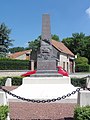
Fallen memorial

Floor cross on Rue de Bourg et Comin
_Monument_aux_morts.JPG)
_Croix_de_chemin.JPG)
Economy and Infrastructure
There are two farms in the municipality of Œuilly (mainly cereal growing).
The D925 trunk road from Soissons to Guignicourt runs through the municipality of netuilly, which follows the Aisne valley . There is a connection to the A 26 autoroute near Guignicourt . The closest train station on the railway line from Reims to Laon is located 20 kilometers to the east of Villeneuve-sur-Aisne .