Coincy (Moselle)
| Coincy | ||
|---|---|---|

|
|
|
| region | Grand Est | |
| Department | Moselle | |
| Arrondissement | Metz | |
| Canton | Le Pays messin | |
| Community association | Haut Chemin-Pays de Pange | |
| Coordinates | 49 ° 7 ' N , 6 ° 17' E | |
| height | 194-259 m | |
| surface | 7.15 km 2 | |
| Residents | 313 (January 1, 2017) | |
| Population density | 44 inhabitants / km 2 | |
| Post Code | 57530 | |
| INSEE code | 57145 | |
 Look at Coincy |
||
Coincy is a French commune with 313 inhabitants (as of January 1, 2017) in the Moselle department in the Grand Est region (until 2015 Lorraine ).
geography
The municipality of Coincy is located immediately east of Metz .
Coincy includes the two hamlets Colombey (1916-1917 Germanized Taubenhof ), made famous by the Battle of Colombey in 1870, and Aubigny (1916-1918 and 1940-1944 Germanized Albenach ).
history
Coincy is derived from the Latin Quintus , the place was first mentioned in the 10th century as Consiagus .
During the Franco-Prussian War in 1870 Coincy was burned down and after the peace treaty came to the German Empire . During the First World War the place name was translated into German in Konzich in 1915, and in 1918 Coincy was returned to France.
During the Second World War , the place was reoccupied by the Germans (June 1940), who drove a large part of the population until the liberation (November 21, 1944) .
coat of arms
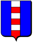
Description: Blue a six white-red gestückter stake .
Population development
| year | 1962 | 1968 | 1975 | 1982 | 1990 | 1999 | 2007 |
| Residents | 116 | 107 | 137 | 202 | 272 | 286 | 310 |
