
Ore Railway (Bochum)


The ore railway in Bochum was a railway line to supply the blast furnaces of the Bochum Association with iron ore . It began in Gelsenkirchen on the Rhine-Herne Canal and led for about nine kilometers south to the former Bochum club on the edge of Bochum city center .
The railway line was built in several sections south of the Rhine-Herne Canal ; the bridges on the railway line give an insight into the respective bridge construction technology over a period of 30 years. Construction began in 1901 and the Schalker Verein steelworks, among other things, was connected to the rail network. Due to the numerous traffic connections in the east-west direction along the ore line, the route was laid on an approximately 15-meter-high dam with 15 bridges. With the construction of the pillar bridge in 1918/19 the Alma colliery in Gelsenkirchen was connected to the railway. It was not until the final expansion stage in 1930 that the line was expanded to the Bochumer Verein steelworks and was used for transporting ore. At the same time, it was an important siding for the Carolinenglück colliery and its coking plant , which was only 1.5 kilometers north of the Bochumer Verein's blast furnaces.
Creation of the cycle path
After the blast furnace operation at the Bochumer Verein ended in the sixties, the ore railway was no longer needed and gradually fell into disrepair. Earlier plans for other uses of the route were not carried out, so a green corridor in a north-south direction in a densely populated area was retained. From 2002 to 2008 the route was dismantled to a cycle path . This enabled the Westpark to be connected to the Emscher cycle path without crossing . The course of the route on a dam allows an excellent view of the surrounding industrial and residential landscape. In the course of the route there are some larger, sometimes spectacular bridge structures, including the newly built ore railway swing over Gahlensche Strasse , the pillar bridge and the Grimberger Sichel . In 2012, the stretch from the Erzbahnschwinge (Bochum) to the pillar bridge (Gelsenkirchen) was paved throughout. In October 2016 the section to the north (from the pier bridge towards Gelsenkirchen) was paved.
Description of the route

The ore railway line has a total length of nine kilometers and begins at Westpark in Bochum (western city center). To the northwest of the Jahrhunderthalle , the route runs over the Erzbahnschwinge ( 51 ° 29 ′ 3.4 ″ N , 7 ° 11 ′ 43.4 ″ E ) , which initially runs parallel to the Thyssen-Krupp works' railway connection, which is still being used . After crossing the Ruhr Schnellweg A 40, the route touches the site of the Carolinenglück colliery , which for a long time did not deliver the coking coal for the Bochum association via the railway line but by means of a cable car . Above shaft 2 there is an inconspicuous Malakow tower built around 1856 and above shaft 3 one of the rare German strut scaffolding of the Zschetzsche type , which was erected around 1912. The shaft is still being driven on and is used for central drainage. The colliery was shut down in 1964. After the colliery shut down, industrial companies (Bochum galvanizing plant, scrap yard) have settled next to the route.
In the further course, the route touches the Dahlhauser Heide settlement in Bochum-Hordel. The embankment towers above the site by ten to twelve meters. The massive Malakow Tower (shaft 1 of the Hannover colliery ) rises above the tree tops. In Wattenscheid-Günnigfeld, a longer bridge structure crosses the street of the same name. At the Ückendorf junction, the connection to the Zollverein cycle path was created in 2005 via the Kray-Wanner railway line . From here, the Zeche Zollverein in Essen-Stoppenberg can be reached via a completely completed cycle path.
A particularly impressive section follows the ore railway line, the pier bridge ( 51 ° 30 ′ 46.9 ″ N , 7 ° 8 ′ 19 ″ E ) . The first part spans the Herne-Wanne-Gelsenkirchen freight railway. This is followed by an intermediate part made up of 21 fields made up of riveted box profiles. The bike path now rests on the profiles. Railings were attached in the course of the renovation. Riveted steel and concrete supports were used. The last part is the bridge over the line of the Cologne-Mindener Eisenbahn-Gesellschaft .
The bridge over Elfriedenstrasse and Gelsenkircher Strasse consists of two sections. While the eastern part has been converted into a cycle path, the tracks are still on the western part. The route now forms the border between the cities of Gelsenkirchen and Herne. Bridge structures follow at shorter intervals, and the Emschertal Railway is passed. To the east you have a view of the Pluto-Wilhelm shaft , which, like shaft XII of the Zollverein colliery, was also designed by Fritz Schupp . The height of the embankment above the ground level decreases continuously in the further course.
The double bridge trailer follows on Wilhelmstrasse. The embankment above the surrounding level flattens towards the port. The route leads along the Pluto heap, which has so far been barely accessible. The canalised Hüller Bach runs on the western side. The motorway A 42 is crossed under and then the port of Grimberg on the Rhine-Herne Canal in Gelsenkirchen is reached, which is the end point of the former ore railway.
In a new continuation, the cycle path here initially runs next to Grimbergstrasse in the Gelsenkirchen city area. The Hüller Bach will be crossed with a new bridge for the footpath and bike path. Shortly afterwards you reach the eastern boundary of the ZOOM Erlebniswelt (former Ruhrzoo), where you can look into the landscape. A bridge over the Rhine Herne channel has been established at the northeast corner of the zoos, as Grimberger sickle is referred to ( 51 ° 32 '50.3 " N , 7 ° 6' 48.5" O ) . The bridge parts were joined together on October 25, 2008 with the help of a floating crane. The official inauguration of the last section of the ore railway line took place as part of a ceremony on October 26, 2008. The bridge was opened to the public at the end of April 2009; the official opening ceremony for the bridge took place on June 20, 2009. Guests were among others the responsible Minister of North Rhine-Westphalia Uhlenberg , the mayors of the participating cities and those responsible for the RVR.
With the crossing of the canal, the forest area of the Emscherbruch is reached. From there there are connections to the Canal Cycle Path or the Emscher Cycle Path. The König-Ludwig-Trasse can be reached via these cycle paths in an easterly direction, which in turn is to be extended to the Münsterland in the long term . In a northerly direction, the cycle path to the Hoheward and Hoppenbruch dumps and the Ewald colliery can be reached by crossing the B 226. At this point, a pedestrian traffic light should defuse the unsafe traffic situation.
Pit water pipe
The bill Carolinenglück still serves the since their demise in 1964 dewatering , the pumped-salt-rich mine water was until 2008 in the channeled Hüller Mühlebach initiated, which flows into the Emscher. The permit for this discharge into natural watercourses expired in 2010. Deutsche Steinkohle (DSK) therefore built a pit water pipe in the route as well as under or next to the bridge structures at the same time and in cooperation with the repair of the ore railway by the RVR. The lines consist of steel pipes that are lined with concrete casing on the inside. One of the two 400 mm pipes is constantly in operation, the other is used as a reserve. One of the two 100 mm pipes is designed as a drainage facility, the other accommodates the control technology. On the route there are inspection openings in the ground, on the bridges the pipes are partly routed below the bridge body (e.g. pier bridge), partly next to the bridge (see photo on Florastraße below).
In 2009, leaks occurred on the kinking pipe parts, which have since been fixed as part of the warranty.
The bridges in detail
| km | designation | Illustration | annotation | place |
|---|---|---|---|---|
| 0.0 | Ore rail swing arm |

|
The Erzbahnschwinge is located at the Jahrhunderthalle in Bochum. On it you leave the Westpark towards the northwest. This bridge was designed by Jörg Schlaich . | Bochum |
| 0.5 | Bridge over the Marbach and the freight railway track |

|
On the works railway between the Krupp factories in Bochum.
Seen from the southwest. |
Bochum |
| 0.6 | Bridge over the Rheinische Bahn |

|
Riveted, single-track and 46 meter long truss bridge from 1928 | Bochum |
| 1.0 | Bridge over the A 40 |

|
Double-track, sheet steel privacy protection on one side and grille on the other. | Bochum |
| 1.1 | Bridge over the Darpestrasse |

|
The bridge over Darpestrasse is located next to the A 40 in Bochum. Shaft 3 of the Carolinenglück colliery can be seen in the background . The shaft will continue to be kept open for the central dewatering.
View from the south. |
Bochum |
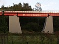
| 3.2 | 'Red Bridge' |

|
1926–1928 built bridge with a span of 45 meters, which crosses the approximately six meter high dam of the former Reichsbahn line Gelsenkirchen-Wattenscheid to Wanne.
Seen from the northeast |
Bochum |
| 3.6 | Bridge over the street Am Blumenkamp |

|
Looking north-west | Bochum |
| 3.9 | Bridge over Günnigfelder Strasse |

|
A 99-meter-long bridge, probably built in 1928, which was extensively restored for use as a cycle path.
Direction of view: southeast |
Bochum |
| 4.7 | Bridge over the path between the shelter and the cemetery |

|
After the line was closed, the bridge section was dismantled. In the course of the new use, the steel bridge was placed on the refurbished abutments. | Herne |
| 5.1 | Bridge over Hofstrasse |

|
The bridge trailer, made of a steel box and handrail bracing, was put on in place of the dismantled bridge part as part of the new use in 2005. | Herne |
| 5.7 | Pier bridge |

|
At 344 m, the pier railway is the longest bridge section of the ore railway. It was built in 1918-1919 to connect the Alma colliery to the railway. The bridge's roadway is 14 meters above ground level. The structure spans the Gelsenkirchen-Wanne freight railway line with two half-timbered constructions of 33 meters in length and the Cologne-Minden railway with 45.6 meters. In between there are 21 steel fields with a length of 13.35 meters each, which are bolted to the foundation and could thus be readjusted if mining damage occurred. The repair of the bridge was completed at the end of 2005. The box bridges were lifted during the renovation. The picture showed the view from the northwest, about 2/3 of the bridge length can be seen. |
Gelsenkirchen |
| 6.1 | Bridge over Elfrieden- and Gelsenkircher Str. |

|
The bridge over Elfrieden- or Gelsenkircher Str. And the Hüller Bach was built between 1912 and 1914.
Recording from November 2005 |
Gelsenkirchen / Herne |
| 6.9 | Bridge over the Florastrasse |

|
Seen from the south. On the right some pipes from the pit water pipe | Herne |
| 7.2 | Bridge east of the Gelsenkirchen Ostfriedhof |

|
The second track was deliberately not dismantled to demonstrate the original route. | Herne |
| 7.5 | Bridge over the Bickernstrasse |

|
Bickerer Höfe | Herne |
| 7.8 | Bridge over Wilhelmstrasse |

|
The span of this bridge is 20.2 meters.
On this picture from December 2006, the cycle and hiking trail north of Wilhelmstrasse (in the background) is not yet completed. |
Herne |
| 9.5 | Bridge over the Hüller Bach |

|
The bridge built in 2008 between the zoo and the harbor over the Hüller Bach at the Grimberg harbor parallel to Grimbergstraße in Gelsenkirchen-Bismarck, seen from the north-west | Gelsenkirchen |
| 10.2 | Grimberger Sichel over the Rhine-Herne Canal |

|
The asymmetrical steel structure crosses the canal in a semicircular arc. Hanging only from a 48 meter high steel pylon on the north side of the canal, the curved bridge has a span of around 150 meters. The northern, 37-meter-long ramp is formed by concrete retaining walls, the southern, 34-meter-long ramp is made as an earth dam. More than 600 cubic meters of concrete and 235 meters of large bored piles were used for the abutments, as well as 400 tons of steel and 465 meters of rope for the suspension structure. In September 2010 the Grimberger Sichel received the European Steel Bridges Award 2010 in the category "Pedestrian Bridges". | Gelsenkirchen |
More pictures

Ore rail swing arm from below
Middle part of the pier bridge

Pillar of the pillar bridge

Pillar bridge before the renovation in 2004

Construction work on the pier bridge (2004)

Erzbahntrasse at the port of Grimberg (11/2007) with one of the remaining bunkers

Sickle bridge (sharp side inside)


literature
- Rüdiger Harnach, Oliver Buckenauer, Ute Kartenberg: Historical, technical study of the ore railway route. October 2001.
- Regional Association Ruhr, Department of Leisure and Tourism (Ed.): Erzbahn-Emscherbruch (theme route 8 of the “Route of Industrial Culture”). Essen 2005, ISBN 3-932165-43-8 .
Individual evidence
- ^ Information service Ruhr: "Grimberger Sichel": Awarded RVR bridge now has a name from August 27, 2010
- ^ "Erzbahntrasse and Kray-Wanner-Bahn asphalted" , ADFC Bochum, accessed on May 24, 2012
- ↑ Erzbahntrasse closed - section gets new asphalt . WAZ, Gelsenkirchen edition, September 21, 2016.
- ↑ lecture by Christoph Haep, RVR Ruhr green, along the rail trail on 19 May 2009 at the House of History of the Ruhr .
- ^ Information service Ruhr: RVR bridge over the Rhine-Herne Canal receives European bridge construction award from August 13, 2010
Web links
- Description of all locations on this themed route as part of the Route of Industrial Culture
- Web slide show about the renovation of the ore railway line
- Project database of the metropolitan clock
- Foot and cycle bridge over the Rhine-Herne Canal, Grimberg harbor - Gelsenkirchen, documentation of the competition, October 2006 (PDF file; 3.03 MB)
Visitor center and anchor points (from west to east): Museum of German Inland Shipping | Inner harbor Duisburg | LVR Industrial Museum Oberhausen | Landscape Park Duisburg-Nord | Gasometer Oberhausen | Aquarius Water Museum | St. Antony Hut | Villa Huegel | Nordsternpark | Zeche Zollverein World Heritage Site and Zollverein Coking Plant | Ewald colliery | Marl Chemical Park | Railway Museum Bochum-Dahlhausen | Henrichshütte | Centennial Hall Bochum | Recklinghausen substation | German Mining Museum | Nightingale colliery | Henrichenburg ship lift | DASA | Hansa coking plant | Zeche Zollern II / IV | Hohenhof | Hagen Open Air Museum | Lindenbrauerei Unna | Maximilian Park Hamm
Themed routes (in ascending order by number): 1. Duisburg: City and Harbor | 2. Industrial cultural landscape Zollverein | 3. Duisburg: industrial culture on the Rhine | 4. Oberhausen: Industry makes the city | 5. Krupp and the city of Essen | 6. Dortmund: triad coal, steel and beer | 7. Industrial culture on the Lippe | 8. Erzbahn-Emscherbruch | 9. Industrial culture at Volme and Ennepe | 10. Brine, steam and coal | 11. Early industrialization | 12. The past and present of the Ruhr | 13. On the way to the blue Emscher | 14. Canals and shipping | 15. Lanes in the area | 16. Westphalian mining route | 17. Rhenish mining route | 18. Chemistry, Glass and Energy | 19. Workers' settlements | 20. Entrepreneur villas | 21. Bread, grain and beer | 22. Myth of the Ruhr Area | 23. Parks and Gardens | 24. Industrial nature | 25. Panoramas and Landmarks | 26. Sacred buildings | 27. Iron & Steel | 28. Water: works, towers and turbines | 29. Bochum - industrial culture in the heart of the district | 30. Gelsenkirchen | 31. Industrial Culture and Bauhaus Route | by bike
Centennial Hall Bochum ![]() |
Westpark |
Colosseum |
Mechanical workshops of the Bochumer Verein |
Stahlhausen settlement |
Bochum Transport Technology Association |
Ore rail link |
Ore railway |
Glückauf settlement |
United Carolinenglück colliery 2/3 |
Epiphany Church - Autobahn Church RUHR |
Dahlhauser Heide settlement
|
Westpark |
Colosseum |
Mechanical workshops of the Bochumer Verein |
Stahlhausen settlement |
Bochum Transport Technology Association |
Ore rail link |
Ore railway |
Glückauf settlement |
United Carolinenglück colliery 2/3 |
Epiphany Church - Autobahn Church RUHR |
Dahlhauser Heide settlement ![]() |
Ore Railway Bridge 4 |
Hannover Colliery 1/2/5 |
Workers' houses Am Rübenkamp |
Königsgrube settlement |
Ore Railway Bridge 6 |
Hanover Colony |
Erzbahnbrücke 9 - pillar bridge |
Kray Wanner Railway |
Alma coking plant |
Torhäuser, Schalke Club |
Chatten- / Preußenstraße settlement |
Ore Railway Bridge 10 |
Erzbahnbrücke 11 |
Ore Railway Bridge 13 |
Ore Railway Bridge 14 |
Pluto-Wilhelm colliery |
Consolidation 3/4/9 |
Graf Bismarck Colliery 1/4 |
Railway depot Gelsenkirchen-Bismarck |
Port of Grimberg |
Grimberger sickle |
Zeche Unser Fritz 1/4 |
Local museum Our Fritz |
Künstlerzeche Our Fritz 2/3 |
Rhine-Herne Canal |
Fleuthe Bridge |
Port Wanne-West |
Wanne-Eickel lock |
Recklinghausen training mine |
Recklinghausen Colliery I |
Recklinghausen II colliery |
Dreieck-Siedlung Hochlarmark |
Landscape Park Hoheward
|
Ore Railway Bridge 4 |
Hannover Colliery 1/2/5 |
Workers' houses Am Rübenkamp |
Königsgrube settlement |
Ore Railway Bridge 6 |
Hanover Colony |
Erzbahnbrücke 9 - pillar bridge |
Kray Wanner Railway |
Alma coking plant |
Torhäuser, Schalke Club |
Chatten- / Preußenstraße settlement |
Ore Railway Bridge 10 |
Erzbahnbrücke 11 |
Ore Railway Bridge 13 |
Ore Railway Bridge 14 |
Pluto-Wilhelm colliery |
Consolidation 3/4/9 |
Graf Bismarck Colliery 1/4 |
Railway depot Gelsenkirchen-Bismarck |
Port of Grimberg |
Grimberger sickle |
Zeche Unser Fritz 1/4 |
Local museum Our Fritz |
Künstlerzeche Our Fritz 2/3 |
Rhine-Herne Canal |
Fleuthe Bridge |
Port Wanne-West |
Wanne-Eickel lock |
Recklinghausen training mine |
Recklinghausen Colliery I |
Recklinghausen II colliery |
Dreieck-Siedlung Hochlarmark |
Landscape Park Hoheward ![]() with the dumps Hoheward / Hoppenbruch |
Emscherbruch |
Ewald colliery |
with the dumps Hoheward / Hoppenbruch |
Emscherbruch |
Ewald colliery |![]()
![]()
Henrichenburg ship lift ![]() |
Waltrop lock park |
Port of Dortmund |
City port of Lünen |
Prussia port |
Marina Rünthe |
Hamm city harbor |
Hamm lock |
Water handover Hamm |
Werries lock |
Way to school footbridge |
Lippe lock Heessen |
Canal bridge Alte Fahrt |
"Schiefe Brücke" and Steverbrücke Olfen |
Canal cross dates |
Datteln-Natrop lock group |
Remote control center for water supply Datteln |
Hermann Grochtmann Museum | Former Lippe lock Datteln |
Port of Victor |
Lock Herne-Ost |
Former lock Herne-West |
Recklinghausen city harbor |
Wanne-Eickel lock |
Port Wanne-West |
Grimberg harbor and ore railway |
City port of Gelsenkirchen |
Gelsenkirchen lock |
Essen city harbor |
Port of Bottrop |
Oberhausen lock |
Gahlener Kohlenweg |
Former Lippe Harbor Wesel |
Municipal Rhine port of Wesel |
Friedrichsfeld lock group |
Fossa Eugeniana |
Orsoy port |
North Harbor Walsum |
Port of Rhine Prussia |
Museum of German Inland Shipping
|
Waltrop lock park |
Port of Dortmund |
City port of Lünen |
Prussia port |
Marina Rünthe |
Hamm city harbor |
Hamm lock |
Water handover Hamm |
Werries lock |
Way to school footbridge |
Lippe lock Heessen |
Canal bridge Alte Fahrt |
"Schiefe Brücke" and Steverbrücke Olfen |
Canal cross dates |
Datteln-Natrop lock group |
Remote control center for water supply Datteln |
Hermann Grochtmann Museum | Former Lippe lock Datteln |
Port of Victor |
Lock Herne-Ost |
Former lock Herne-West |
Recklinghausen city harbor |
Wanne-Eickel lock |
Port Wanne-West |
Grimberg harbor and ore railway |
City port of Gelsenkirchen |
Gelsenkirchen lock |
Essen city harbor |
Port of Bottrop |
Oberhausen lock |
Gahlener Kohlenweg |
Former Lippe Harbor Wesel |
Municipal Rhine port of Wesel |
Friedrichsfeld lock group |
Fossa Eugeniana |
Orsoy port |
North Harbor Walsum |
Port of Rhine Prussia |
Museum of German Inland Shipping ![]() |
Steiger Schifferbörse |
Haniel building complex |
Steiger Swan Gate |
Inner harbor Duisburg
|
Steiger Schifferbörse |
Haniel building complex |
Steiger Swan Gate |
Inner harbor Duisburg ![]() | Private port Hüttenwerke Krupp Mannesmann |
Ruhrschleuse and Ruhrwehr |
Rhine-Ruhr port of Mülheim |
Ruhr lock and Mülheim water station |
Nightingale colliery
| Private port Hüttenwerke Krupp Mannesmann |
Ruhrschleuse and Ruhrwehr |
Rhine-Ruhr port of Mülheim |
Ruhr lock and Mülheim water station |
Nightingale colliery ![]()
Railway Museum Bochum-Dahlhausen ![]() |
Dahlhausen railway station |
Hattingen train station |
Ruhr Valley Railway |
Henrichshütte
|
Dahlhausen railway station |
Hattingen train station |
Ruhr Valley Railway |
Henrichshütte ![]() |
Railway line Hattingen - Schee - Silschede with the Sprockhövel train station |
Ennepetal station |
Kruiner Tunnel |
Haspe - Voerde - Breckerfeld railway line |
Harkort coal railway |
Viaduct of the Rheinische Eisenbahngesellschaft |
Goldberg tunnel |
Hagen Central Station |
Ruhr-Sieg route |
Herdecke Ruhr Viaduct |
Railway repair shop Schwerte and Kreinberg settlement |
Upper Ruhr Valley Railway and Langschede Station |
Hamm train station |
Kamen train station |
Seseke Bridge |
Immermannstrasse depot |
Local Transport Museum Dortmund |
Turnout construction hall machine factory Germany |
Dortmund Central Station |
Dortmund railway bridge ensemble |
Dortmund depot |
Water tower Dortmund Südbahnhof |
Zeche Zollern II / IV
|
Railway line Hattingen - Schee - Silschede with the Sprockhövel train station |
Ennepetal station |
Kruiner Tunnel |
Haspe - Voerde - Breckerfeld railway line |
Harkort coal railway |
Viaduct of the Rheinische Eisenbahngesellschaft |
Goldberg tunnel |
Hagen Central Station |
Ruhr-Sieg route |
Herdecke Ruhr Viaduct |
Railway repair shop Schwerte and Kreinberg settlement |
Upper Ruhr Valley Railway and Langschede Station |
Hamm train station |
Kamen train station |
Seseke Bridge |
Immermannstrasse depot |
Local Transport Museum Dortmund |
Turnout construction hall machine factory Germany |
Dortmund Central Station |
Dortmund railway bridge ensemble |
Dortmund depot |
Water tower Dortmund Südbahnhof |
Zeche Zollern II / IV ![]() |
Recklinghausen Central Station |
Herne train station |
Wanne-Eickel main station |
Local history and natural history museum Wanne-Eickel |
Railway depot Gelsenkirchen-Bismarck |
Gelsenkirchen Central Station |
Dorsten station |
RBH Logistics |
Werksbahn Bochumer Verein and Erzbahn |
Bochum Association |
Bochum Nord railway station and steel bridges of the Rheinische Bahn |
Bochum Central Station |
BOGESTRA head office |
Langendreer train station (with the cultural center ) |
Tram depot Witten and garden city Crengeldanz |
Switch factory Witten |
Witten Central Station |
Ruhr Viaduct Witten |
Mine and field railway museum Zeche Theresia | Railway systems of the Nachtigall colliery
|
Recklinghausen Central Station |
Herne train station |
Wanne-Eickel main station |
Local history and natural history museum Wanne-Eickel |
Railway depot Gelsenkirchen-Bismarck |
Gelsenkirchen Central Station |
Dorsten station |
RBH Logistics |
Werksbahn Bochumer Verein and Erzbahn |
Bochum Association |
Bochum Nord railway station and steel bridges of the Rheinische Bahn |
Bochum Central Station |
BOGESTRA head office |
Langendreer train station (with the cultural center ) |
Tram depot Witten and garden city Crengeldanz |
Switch factory Witten |
Witten Central Station |
Ruhr Viaduct Witten |
Mine and field railway museum Zeche Theresia | Railway systems of the Nachtigall colliery ![]() and the Muttental |
Zollverein station |
Rheinische Bahn in Essen |
Locomotive factory and works railway Krupp |
Essen Central Station |
Railway Headquarters Essen |
Villa Hügel
and the Muttental |
Zollverein station |
Rheinische Bahn in Essen |
Locomotive factory and works railway Krupp |
Essen Central Station |
Railway Headquarters Essen |
Villa Hügel ![]() and train station Essen-Hügel |
Ruhr Bridge Steele |
Kupferdreh station and Hespertalbahn museum railway | " Hundebrücke " and " Deilthaler Eisenbahn " |
Kettwig railway bridge |
City viaduct and Ruhr bridge Mülheim |
Roundhouse and Camera Obscura |
Railway repair shop Speldorf with the old turning shop |
Tram depot Speldorf |
Bridge landscape Ruhraue |
Shunting yard , railway repair shop Wedau and railway settlement Wedau |
Water Tower Rheinhausen-Friemersheim and railway settlement Rheinhausen-Friemersheim |
Duisburg-Hochfelder Railway Bridge |
Lifting tower "Homberg-Ruhrorter Rheintrajektanstalt" |
Duisburg Central Station |
Green path |
HOAG route |
Thyssen works railway |
House Knipp Railway Bridge |
Rhine bridge Wesel |
Oberhausen Central Station |
LVR Industrial Museum Oberhausen
and train station Essen-Hügel |
Ruhr Bridge Steele |
Kupferdreh station and Hespertalbahn museum railway | " Hundebrücke " and " Deilthaler Eisenbahn " |
Kettwig railway bridge |
City viaduct and Ruhr bridge Mülheim |
Roundhouse and Camera Obscura |
Railway repair shop Speldorf with the old turning shop |
Tram depot Speldorf |
Bridge landscape Ruhraue |
Shunting yard , railway repair shop Wedau and railway settlement Wedau |
Water Tower Rheinhausen-Friemersheim and railway settlement Rheinhausen-Friemersheim |
Duisburg-Hochfelder Railway Bridge |
Lifting tower "Homberg-Ruhrorter Rheintrajektanstalt" |
Duisburg Central Station |
Green path |
HOAG route |
Thyssen works railway |
House Knipp Railway Bridge |
Rhine bridge Wesel |
Oberhausen Central Station |
LVR Industrial Museum Oberhausen ![]()

Centennial Hall Bochum ![]() |
Westpark |
Colosseum |
Mechanical workshops of the Bochumer Verein |
Bochum Transport Technology Association |
Stahlhausen settlement |
Bochum Association, Steel Industry Plant |
Heintzmann Company |
Rombacher Hut |
Bochum Association, Höntrop plant |
Werksbahn Bochumer Verein and Erzbahn |
Glückauf settlement |
United Carolinenglück colliery 2/3 |
Epiphany Church - Autobahn Church RUHR |
Dahlhaus Heide settlement
|
Westpark |
Colosseum |
Mechanical workshops of the Bochumer Verein |
Bochum Transport Technology Association |
Stahlhausen settlement |
Bochum Association, Steel Industry Plant |
Heintzmann Company |
Rombacher Hut |
Bochum Association, Höntrop plant |
Werksbahn Bochumer Verein and Erzbahn |
Glückauf settlement |
United Carolinenglück colliery 2/3 |
Epiphany Church - Autobahn Church RUHR |
Dahlhaus Heide settlement ![]() |
Hannover Colliery I / II / V |
Workers' houses Am Rübenkamp |
Hanover Colony |
Colliery Holland 3/4/6 |
Mining hiking trail Wattenscheid |
Villa Baare |
Railway Museum Bochum |
Dr. C. Otto |
Dahlhausen railway station |
Mining Trail Dahlhausen |
Dahlhausen floating bridge | Grave of Heinrich Kämchen |
Peaceful neighbor colliery |
Peaceful Neighbor Colony |
Weitmar water tower |
Homecoming Thank You Church |
Mining hiking trail Bochum-Süd |
Gahlenscher Kohlenweg |
Brockhauser civil engineering colliery |
Blankenstein lock and Stiepel waterworks |
Klosterbusch colliery and Ruhr University mining trail |
United Gibraltar Mine |
Kemnader See |
Malakow Tower Julius Phillip |
Consumer association welfare |
Fa. Eickhoff |
Melanchthon Church |
Federal Miners' Association |
Bergmannsheil |
House of the History of the Ruhr Area |
Playhouse |
Tippelsberg
|
Hannover Colliery I / II / V |
Workers' houses Am Rübenkamp |
Hanover Colony |
Colliery Holland 3/4/6 |
Mining hiking trail Wattenscheid |
Villa Baare |
Railway Museum Bochum |
Dr. C. Otto |
Dahlhausen railway station |
Mining Trail Dahlhausen |
Dahlhausen floating bridge | Grave of Heinrich Kämchen |
Peaceful neighbor colliery |
Peaceful Neighbor Colony |
Weitmar water tower |
Homecoming Thank You Church |
Mining hiking trail Bochum-Süd |
Gahlenscher Kohlenweg |
Brockhauser civil engineering colliery |
Blankenstein lock and Stiepel waterworks |
Klosterbusch colliery and Ruhr University mining trail |
United Gibraltar Mine |
Kemnader See |
Malakow Tower Julius Phillip |
Consumer association welfare |
Fa. Eickhoff |
Melanchthon Church |
Federal Miners' Association |
Bergmannsheil |
House of the History of the Ruhr Area |
Playhouse |
Tippelsberg ![]() |
Steelworks Bochum |
Industrial nature trail Gerthe / Grumme / Hiltrop |
Christ Church Gerthe |
Lothringen colliery |
Lorraine dump |
Vinzentiuskirche |
Ev. Church of Werne |
Robert Müser Colliery |
Neu-Iserlohn coking plant |
Langendreer train station with the cultural center |
Distillery Eickelberg |
Müser Brewery |
Opel |
Bochum main cemetery |
Scharoun Church |
BP Aral Headquarters |
Bochum City Archives |
Kortum Park |
Bogestra Headquarters |
Bochum Central Station |
Bochum Nord train station and Bochum steel bridges |
Fiege Brewery | Bell Bochumer Verein ( town hall ) |
Schlegel Brewery |
Christ Church Bochum Center |
Sparkasse Bochum |
Villa Nora and Villa Rosenstein-Markhoff |
City Park Bochum |
Mountain School TFH Georg Agricola |
German Mining Museum
|
Steelworks Bochum |
Industrial nature trail Gerthe / Grumme / Hiltrop |
Christ Church Gerthe |
Lothringen colliery |
Lorraine dump |
Vinzentiuskirche |
Ev. Church of Werne |
Robert Müser Colliery |
Neu-Iserlohn coking plant |
Langendreer train station with the cultural center |
Distillery Eickelberg |
Müser Brewery |
Opel |
Bochum main cemetery |
Scharoun Church |
BP Aral Headquarters |
Bochum City Archives |
Kortum Park |
Bogestra Headquarters |
Bochum Central Station |
Bochum Nord train station and Bochum steel bridges |
Fiege Brewery | Bell Bochumer Verein ( town hall ) |
Schlegel Brewery |
Christ Church Bochum Center |
Sparkasse Bochum |
Villa Nora and Villa Rosenstein-Markhoff |
City Park Bochum |
Mountain School TFH Georg Agricola |
German Mining Museum ![]()