
Etzelpass
| Etzelpass | |||
|---|---|---|---|
 Pass summit with restaurant and St. Meinrad Chapel |
|||
| Compass direction | North | south | |
| Pass height | 950 m above sea level M. | ||
| Canton | Schwyz | ||
| Watershed | Talbach → Lake Zurich → Limmat → Aare → Rhine | Sihl → Limmat → Aare → Rhine | |
| Valley locations | Pfäffikon SZ | Einsiedeln | |
| expansion | Street | ||
| Built | ? | ||
| Lock | - | ||
| profile | |||
| Ø pitch | 12% (529 m / 6 km) | 1.3% (64 m / 5 km) | |
| Max. Incline | 13.7% (on km 3) | 20% (on km 0.9) | |
 |
|||
| Map (Switzerland) | |||
|
|||
| Coordinates | 701 096 / 225 567 | ||

The Etzelpass is a pass in the Swiss canton of Schwyz , which leads from Pfäffikon SZ to Einsiedeln . The pass is at 950 m above sea level. M. below the Etzel . The length of the pass road from Pfäffikon to Einsiedeln is 12 kilometers. Part of the road is also a hiking trail and the road profile is dimensioned for local traffic and accordingly not suitable for through traffic.
The St. Meinrad Chapel, named after Meinrad von Einsiedeln , and an inn stand at the top of the pass . They are on the pilgrimage route of the Way of St. James , which leads from the Zurich Oberland over the Etzel Pass to the pilgrimage site of Einsiedeln and from there to Santiago de Compostela in northern Spain .
history
The Etzel Chapel was first mentioned in a document in the 13th century. In 1698 it was demolished and rebuilt according to plans by Caspar Moosbrugger . The stucco was created by Pietro Neuroni from Lugano , the frescoes by Francesco Antonio Giorgioli from Meride . In 1960 the chapel was restored and placed under the protection of the Swiss Confederation. The last renovation took place in 2010 and 2011.
The originally wooden pilgrim house dates back to the 14th century. After a fire, today's inn was built in 1759 according to plans by brother Kaspar Braun, who also built the royal stables in Einsiedeln. In 1983 the building was completely restored.
From 1941 the Etzel Pass was secured by several infantry bunkers and tank obstacles. The Etzel lock was part of the Swiss Réduit .
gallery

St. Meinrad Chapel on the Etzel Pass
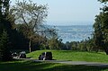
The narrow street is also a hiking trail - here on the north side with a view of Lake Zurich

Etzelpass with Devil's Bridge in autumn

Infantry bunker Etzelpass Ost A 7104 and GPH 3605

Historical aerial photo from 1250 m by Walter Mittelholzer from 1934


Web links
← Previous location: Pfäffikon SZ | Etzelpass | Next place: Devil's Bridge →
Ächerli • Agites • Aiguillon • Albis • Albula • Balmberg • Benkerjoch • Bernina • Böhler • Bözberg • Breitehöchi • Brünig • Buechenegg • Bürersteig • Chall • Challhöchi Pass • Champex • Chasseral • Chatzenstrick • Chilchzimmersattel • Croix • Croix • Croix de Coeur • Eichhöhe • Étroits • Etzelpass • Flüela • Forclaz • Furka • Ghöch • Givrine • glass • Glaubenberg • Glaubenbielen • Gottschalkenberg • Grimsel • Grosse Scheidegg • Gr.St.Bernhard • Gurnigel • Haggenegg • Hahnenmoos • Heitersberg • Hilferen • Hirzel • Hirzel Höhi • Hulftegg • Ibergeregg • Jaman • Jaun • Julier • Kerenzerberg • Klausen • Kunkels • Lein • Lenzerheide • Livigno • Lukmanier • Maloja • Marchairuz • Mollendruz • Mont Crosin • Monte Ceneri • Mont d'Orzeires • Montvoie • Morgins • Mosses • Mutschellen • Neggia • Nufenen • Oberalp • upper Hauenstein • Oberricken • oven • Orn • Passwang • Pierre Pertuis • Pillon • Planches • Pontins • Pragel • edge crossing • Rangiers • rates • Rengg • crocheted • Roches • 'groups • R üsler • Saanenmöser • Salhöhe • San Bernardino • Sanetsch • Santelhöchi • Sattel • Sattelegg • Schafmatt • Schallenberg • Schelten • Schönau • Schufelberger Egg • Schwägalp • Schwarzenbühl • Siblingerhöhe • Simplon • Splügen • St. Anton • St. Gotthard • St. Luzisteig • Staffelegg • Stoss • Susten • Tourne • Tronc • Umbrail • Unterer Hauenstein • Front Höhi • Vue des Alpes • Wasserfluh • Weissenstein • Wildhaus • Wissegg • Wolfgang