
Saint-Sauveur (Dordogne)
| Saint-Sauveur | ||
|---|---|---|

|
|
|
| region | Nouvelle-Aquitaine | |
| Department | Dordogne | |
| Arrondissement | Bergerac | |
| Canton | Bergerac-2 | |
| Community association | Agglomération Bergeracoise | |
| Coordinates | 44 ° 52 ′ N , 0 ° 35 ′ E | |
| height | 50-141 m | |
| surface | 9.31 km 2 | |
| Residents | 847 (January 1, 2017) | |
| Population density | 91 inhabitants / km 2 | |
| Post Code | 24520 | |
| INSEE code | 24499 | |
_mairie.JPG) Town hall ( Mairie ) of Saint-Sauveur |
||

Saint-Sauveur (locally and Saint-Sauveur-de-Bergerac called) is a French municipality with 847 inhabitants (at January 1, 2017) in the department of Dordogne in the region Nouvelle-Aquitaine (before 2016: Aquitaine ). The municipality belongs to the Arrondissement of Bergerac and the canton of Bergerac-2 .
The name in the Occitan language is Sent Salvador and is derived from Salvator mundi , the honorary title of Jesus Christ .
The inhabitants are called Salvadorien and Salvadoriennes .
geography
Saint-Sauveur is located about seven kilometers east of Bergerac in its catchment area ( Aire urbaine ) in the Bergeracois area of the historic province of Périgord .
The community is located in a wooded area. About 60% of the agricultural area is covered with forest, the rest with vineyards.
Saint-Sauveur is surrounded by the five neighboring municipalities:
| Lembras | Lamonzie-Montastruc | Liorac-sur-Louyre |
.svg)
|
||
| Creysse | Mouleydier |
Saint-Sauveur is located in the catchment area of the Dordogne river . The Caudeau , one of its right tributaries, marks a section of the border with the northern neighboring municipality of Lamonzie-Montastruc.

The municipality received the “A Flower” award from the Conseil national des Villes et Villes Fleuris (CNVVF) as part of the annual competition for cities and towns decorated with flowers.
coat of arms
The coat of arms was adopted by the municipality on February 26, 1993 and can be interpreted as follows: The coat of arms in the left ( heraldic right ) upper corner shows the symbol of a castle or a chateau and represents the Grateloup Castle, which is located in the municipality . The colors gold and blue below are those of the philosopher Maine de Biran , who lived in Grateloup Castle. The right (heraldic left) upper corner shows the Tolosan cross . Below is the Coulobre , a kind of dragon that, according to legend , was knocked down by the holy Fronto of Périgueux .
Population development
After records began, the population rose to an initial high of 460 in the middle of the 19th century. In the following period, the size of the community fell to around 250 inhabitants during short recovery phases up to the 1920s, before a phase of at times strong growth began that continues today.
| year | 1962 | 1968 | 1975 | 1982 | 1990 | 1999 | 2006 | 2011 | 2017 |
|---|---|---|---|---|---|---|---|---|---|
| Residents | 284 | 334 | 420 | 529 | 605 | 606 | 733 | 789 | 847 |

Attractions
- Parish church of La Transfiguration de Notre Dame du Seigneur , partly new building from the 19th century with the grave of the philosopher Maine de Biran
- Grateloup Castle from the 18th century, partly inscribed as a monument historique
- Biran Castle from the 17th century
- Les Bourdies mansion, a 15th century Chartreuse

Parish Church of La Transfiguration de Notre Dame du Seigneur
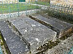
Graves of the Maine de Biran family next to the church

Les Bourdies mansion
_%C3%A9glise.JPG)
_%C3%A9glise_tombes_Maine_de_Biran.JPG)
.JPG)
Economy and Infrastructure

The economic activities are based on viticulture, but also on trade and services.
Saint-Sauveur is located in the AOC des Bergerac with the appellations Bergerac (blanc, rosé, rouge) , Côtes de Bergerac (blanc, rouge) and des Pécharmant .

total = 58
education
The municipality has a public preschool and elementary school with 43 pupils in the 2018/2019 school year.
traffic
Saint-Sauveur can be reached from Routes départementales 21, 21E1 and 32.

Personalities
- Marie François Pierre Gontier de Biran, called Maine de Biran, born on November 29, 1766 in Bergerac, died on July 16, 1824 in Paris , was a French philosopher. He lived in Saint-Sauveur in his castle Grateloup, his grave is in Saint-Sauveur next to the church.
- Henri Sicard, born on October 6, 1914 in Saint-Sauveur, died on October 13, 1992 in Bergerac, was a French politician. From November 30, 1958 to October 9, 1962 he was a member of the Dordogne Department in the National Assembly .
Web links
Individual evidence
- ↑ Le nom occitan des communes du Périgord ( fr ) Départementrat des Dordogne. Retrieved January 18, 2019.
- ↑ Dordogne ( fr ) habitants.fr. Retrieved January 18, 2019.
- ↑ Aire urbaine de Bergerac (109) ( fr ) INSEE . Retrieved January 18, 2019.
- ↑ Saint-Sauveur-de-Bergerac ( fr , PDF) Communauté d'agglomération Bergeracoise. Retrieved January 18, 2019.
- ↑ Ma commune: Saint-Sauveur ( fr ) Système d'Information sur l'Eau du Bassin Adour Garonne. Retrieved January 18, 2019.
- ↑ Toutes les communes fleuries ( fr ) Conseil national des villes et villages fleuris. Retrieved January 18, 2019.
- ↑ a b Mairie de Saint Sauveur de Bergerac ( fr ) Pays de Bergerac Tourisme. Archived from the original on June 3, 2017. Retrieved January 18, 2019.
- ↑ Notice Communale Saint-Sauveur ( fr ) EHESS . Retrieved January 18, 2019.
- ↑ Populations légales 2016 Commune de Saint-Sauveur (24499) ( fr ) INSEE . Retrieved January 18, 2019.
- ↑ Saint-Sauveur ( fr ) Conseil régional d'Aquitaine. Archived from the original on September 9, 2016. Retrieved January 18, 2019.
- ↑ Institut national de l'origine et de la qualité: Rechercher un produit ( fr ) Institut national de l'origine et de la qualité . Retrieved January 18, 2019.
- ↑ Caractéristiques des établissements en 2015 Commune de Saint-Sauveur (24499) ( fr ) INSEE . Retrieved January 18, 2019.
- ^ École maternelle et élémentaire ( fr ) National Ministry of Education. Retrieved January 18, 2019.
- ^ Henri Sicard ( fr ) National Assembly. Retrieved January 18, 2019.