Üdersdorf
| coat of arms | Germany map | |
|---|---|---|

|
Coordinates: 50 ° 9 ′ N , 6 ° 48 ′ E |
|
| Basic data | ||
| State : | Rhineland-Palatinate | |
| County : | Vulkaneifel | |
| Association municipality : | Down | |
| Height : | 438 m above sea level NHN | |
| Area : | 17.47 km 2 | |
| Residents: | 1118 (Dec. 31, 2019) | |
| Population density : | 64 inhabitants per km 2 | |
| Postal code : | 54552 | |
| Area code : | 06596 | |
| License plate : | DAU | |
| Community key : | 07 2 33 075 | |
| Community structure: | 3 districts | |
| Association administration address: | Leopoldstrasse 29 54550 Daun |
|
| Website : | ||
| Local Mayor : | Günter Altmeier | |
| Location of the local community Üdersdorf in the Vulkaneifel district | ||
Üdersdorf is a municipality in the Vulkaneifel district in Rhineland-Palatinate . She belongs to the community of Daun . Üdersdorf is a state-approved resort .
geography
The districts of Tettscheid and Trittscheid belong to the community. Üdersdorf is a state-approved resort and offers a variety of hiking trails in a wooded area in the middle of the Vulkaneifel .
The crater lakes and the Liesertal are in the immediate vicinity. The health resorts of Daun and Manderscheid and the Nürburgring are in the vicinity .
history
General
Üdersdorf was first mentioned in a document in 1287 in a deed of donation. The income from the village "Oistersdorf" was transferred to the Himmerod monastery . In the Trier fire book of 1563 , twelve “fire places” or households with around 70 inhabitants were counted in Üdersdorf, and 7 households each in Trittscheid and Tettscheid.
Until 1794 the place belonged to the Electorate of Trier Daun. At the time of the French administration, Üdersdorf was the capital of a Mairie , after the takeover of the Rhineland , to which Üdersdorf belonged at that time, through Prussia the place came to the then newly formed Daun district in 1815/1816 and was the seat of a mayor's office . The towns of Uederdorf with the Uederdorfer mill, Nieder-Stattfeld , Ober-Stattfeld , Tettscheid, Trittscheid and Weyersbach (today's Daun district of Weiersbach ) belonged to the mayor's office of Üdersdorf . In 1878 the official seat was moved to Niederstadtfeld.
The first chapel stood in the village early on, and in 1717 a church dedicated to St. Bartholomew was built there. The current church was built in the 1860s. A local parish school has been known since 1769. A first school building was built in 1824, and in 1936 the building that still serves as a primary school today.
On January 1, 1971, the two previously independent local communities Tettscheid (132 inhabitants) and Trittscheid (148 inhabitants) were incorporated.
- Population development
The development of the population of Üdersdorf in relation to today's municipality, the values from 1871 to 1987 are based on censuses:
|
|
Tettscheid district
Tettscheid was already recorded in 1148 as Texscithe and mentioned in 1161 as Texscith.
politics
Municipal council
The council in Üdersdorf consists of 16 council members, who in the local elections on May 26, 2019 in a majority vote were elected, and the honorary mayor as chairman.
coat of arms
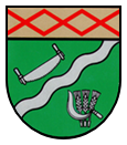
| Blazon : "Under a golden shield head, inside a red slanting grid, green shield divided by a silver, sloping left wavy bar, above a silver saw, below three silver ears, covered with a silver sickle." | |
Parish partnership
A partnership with the Luxembourg municipality of Junglinster has existed since 1987 .
Attractions
In Üdersdorf there are some listed cultural monuments:
Üdersdorf district
- The Catholic parish church of St. Bartholomew, a classicist hall building made of basalt and sandstone, was built in 1863
- The former school, a plastered building from the 19th century (Alte Schulstrasse)
- The former bakery , a single-storey quarry stone building, probably 19th century (Aarleystraße)
- A lateral house from the second half of the 19th century (Dauner Straße)
- Aarley Cross , WWII memorial
- Üdersdorf viewing platform, 12 m high wooden viewing tower built in 2012 at 557.5 m above sea level. NHN high Aarley ( ⊙ )
Tettscheid district
- The Catholic Filialkirche St. Jodocus, a hall building from 1904
- A Streckhof from 1801
Trittscheid district
- A fountain from the second half of the 19th century
See also: List of cultural monuments in Üdersdorf
Web links
- Internet presence of the local community Üdersdorf
- Internet presence of the district of Tettscheid
- To search for cultural assets of the local community Üdersdorf in the database of cultural assets in the Trier region .
Individual evidence
- ↑ State Statistical Office of Rhineland-Palatinate - population status 2019, districts, communities, association communities ( help on this ).
- ^ A b State Statistical Office Rhineland-Palatinate: My village, my city. Retrieved May 6, 2020 .
- ↑ State Statistical Office Rhineland-Palatinate (ed.): Official directory of the municipalities and parts of the municipality. Status: January 2018. S. 71 (PDF; 2.2 MB; municipality is missing in the 2019 directory!).
- ↑ a b c Hans Joachim Theis: 700 years of Üdersdorf. In: Heimatjahrbuch 1987. Landkreis Vulkaneifel, accessed on April 5, 2019 .
- ^ Johann Friedrich Schannat : Eiflia illustrata or geographical and historical description of the Eifel. Volume 3, 1854, p. 159 ( limited preview in Google Book search).
- ↑ Official municipality directory 2006 ( Memento from December 22, 2017 in the Internet Archive ) (= State Statistical Office Rhineland-Palatinate [Hrsg.]: Statistical volumes . Volume 393 ). Bad Ems March 2006, p. 198 (PDF; 2.6 MB). Info: An up-to-date directory ( 2016 ) is available, but in the section "Territorial changes - Territorial administrative reform" it does not give any population figures.
- ↑ Entry on First mention as Oistersdorf (Üdersdorf) in the database of cultural assets in the Trier region ; accessed on May 6, 2020.
- ^ The Regional Returning Officer Rhineland-Palatinate: Local elections 2019, city and municipal council elections.
- ↑ General Directorate for Cultural Heritage Rhineland-Palatinate (ed.): Informational directory of cultural monuments - Vulkaneifel district. Mainz 2020, p. 52 (PDF; 4.6 MB).
- ↑ Map service of the landscape information system of the Rhineland-Palatinate nature conservation administration (LANIS map) (DTK 1: 2.000)
- ^ Aarley (557 m). Rhein-Mosel-Verlag A. Houben e. K., accessed March 20, 2016 .


