
Castandet
| Castandet | ||
|---|---|---|
|
||
| region | Nouvelle-Aquitaine | |
| Department | Country | |
| Arrondissement | Mont-de-Marsan | |
| Canton | Adour Armagnac | |
| Community association | Pays Grenadois | |
| Coordinates | 43 ° 48 ′ N , 0 ° 20 ′ W | |
| height | 67-126 m | |
| surface | 16.66 km 2 | |
| Residents | 398 (January 1, 2017) | |
| Population density | 24 inhabitants / km 2 | |
| Post Code | 40270 | |
| INSEE code | 40070 | |

Castandet is a French municipality with 398 inhabitants (as of January 1 2017) in the department of land in the region Nouvelle-Aquitaine (before 2016: Aquitaine ). The municipality belongs to the arrondissement of Mont-de-Marsan and the canton of Adour Armagnac (until 2015: canton of Grenade-sur-l'Adour ).
geography
Castandet is about 14 kilometers southeast of Mont-de-Marsan . Castandet is surrounded by the neighboring communities of Pujo-le-Plan in the north, Saint-Gein in the northeast, Hontanx in the east, Cazères-sur-l'Adour in the southeast, Bordères-et-Lamensans in the south, Grenade-sur-l'Adour in the Southwest and Maurrin in the west and northwest.
history
The community was founded in 1315 as a bastide by the English.
Population development
| 1962 | 1968 | 1975 | 1982 | 1990 | 1999 | 2006 | 2013 |
|---|---|---|---|---|---|---|---|
| 431 | 433 | 397 | 384 | 375 | 413 | 407 | 403 |
| Source: Cassini and INSEE | |||||||
Attractions
- Saint-Vincent-de-Xaintes church from the 19th century
- Castandet Castle
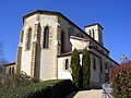
Saint-Vincent-de-Xaintes Church
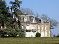
Castandet Castle


Parish partnership
There is a partnership with the French community of Hombourg in the Haut-Rhin department.