
Montaut (Landes)
| Montaut | ||
|---|---|---|

|
|
|
| region | Nouvelle-Aquitaine | |
| Department | Country | |
| Arrondissement | Mont-de-Marsan | |
| Canton | Chalosse Tursan | |
| Community association | Chalosse Tursan | |
| Coordinates | 43 ° 45 ′ N , 0 ° 39 ′ W | |
| height | 25-121 m | |
| surface | 14.88 km 2 | |
| Residents | 626 (January 1, 2017) | |
| Population density | 42 inhabitants / km 2 | |
| Post Code | 40500 | |
| INSEE code | 40191 | |
 Montaut |
||

Montaut is a French municipality with 626 inhabitants (at January 1, 2017) in the Landes department in the region Nouvelle-Aquitaine . It belongs to the arrondissement of Mont-de-Marsan and the canton of Chalosse Tursan . In addition to the main settlement, Montaut also includes the hamlet of Brocas, named after a family of the same name.
Neighboring communities are Toulouzette in the north, Saint-Sever in the northeast, Banos in the east, Doazit in the south, Maylis and Saint-Aubin in the southwest and Hauriet in the west.
Population development
| year | 1962 | 1968 | 1975 | 1982 | 1990 | 1999 | 2008 | 2015 |
|---|---|---|---|---|---|---|---|---|
| Residents | 794 | 766 | 704 | 556 | 592 | 604 | 556 | 644 |
Attractions
- Sainte-Catherine church, a historic monument since 1970
- Saint-Pierre church in Brocas, a historic monument since 1934
- Arcet Chapel
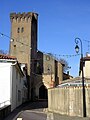
Sainte-Catherine church

Saint-Pierre church

Arcet Chapel


Web links
Commons : Montaut - collection of images, videos and audio files