
Doazit
| Doazit | ||
|---|---|---|
.svg)
|
|
|
| region | Nouvelle-Aquitaine | |
| Department | Country | |
| Arrondissement | Dax | |
| Canton | Coteau de Chalosse | |
| Community association | Terres de Chalosse | |
| Coordinates | 43 ° 41 ′ N , 0 ° 39 ′ W | |
| height | 57-127 m | |
| surface | 22.16 km 2 | |
| Residents | 858 (January 1, 2017) | |
| Population density | 39 inhabitants / km 2 | |
| Post Code | 40700 | |
| INSEE code | 40089 | |
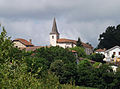
 View of Doazit (village of Mus) |
||

Doazit is a French commune in the department of land in the region Nouvelle-Aquitaine . It is located in the extreme south of the department and has 858 inhabitants (as of January 1, 2017). The municipality is part of the canton of Coteau de Chalosse (until 2015: canton of Mugron ) within the arrondissement of Dax . The inhabitants are called Doazitiens .
geography
Doazit is located about 35 kilometers east of Dax in the Chalosse landscape . Doazit is surrounded by the neighboring communities of Montaut in the north and northwest, Banos in the north, Audignon in the northeast, Horsarrieu in the east, Hagetmau in the southeast, Serreslous-et-Arribans in the south, Saint-Cricq-Chalosse in the south and southwest and Maylis in the west.
population
| year | 1962 | 1968 | 1975 | 1982 | 1990 | 1999 | 2006 | 2013 |
|---|---|---|---|---|---|---|---|---|
| Residents | 1,069 | 1,032 | 901 | 865 | 858 | 884 | 945 | 895 |
Attractions
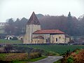
- Saint-Jean-Baptiste church in Aules
- Notre-Dame Church in Doazit
- Saint Martin Church in Le Mus
- Candale Castle
Notre-Dame church

Saint Martin Church
Saint-Jean-Baptiste church

Candale Castle


Personalities
- Jean d'Arcet (1724-1801), chemist