
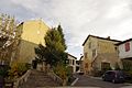
Hastingues
| Hastingues | ||
|---|---|---|
|
||
| region | Nouvelle-Aquitaine | |
| Department | Country | |
| Arrondissement | Dax | |
| Canton | Orthe et Arrigans | |
| Community association | Pays d'Orthe et Arrigans | |
| Coordinates | 43 ° 32 ′ N , 1 ° 9 ′ W | |
| height | 0-84 m | |
| surface | 14.75 km 2 | |
| Residents | 579 (January 1, 2017) | |
| Population density | 39 inhabitants / km 2 | |
| Post Code | 40300 | |
| INSEE code | 40120 | |
 City Hall (Mairie) of Hastingues |
||

Hastingues is a French municipality with 579 inhabitants (at January 1, 2017) in the department of land in the region Nouvelle-Aquitaine (before 2016 Aquitaine ) in southwestern France. It belongs to the Arrondissement of Dax and the canton of Orthe et Arrigans (until 2015 Peyrehorade ). The inhabitants are called Hastingots .
geography
Hastingues is located between the Bidouze and Gaves Réunis rivers, around 30 kilometers east-northeast of Bayonne . Neighboring communities are Orthevielle in the north and north-west, Peyrehorade in the north and north-east, Oeyregave in the east, Came in the east and south-east, Bidache in the south, Bardos in the south-west, Guiche in the west and south-west and Sames in the west.
history
The bastide was founded in 1289 by John Hastings, 1st Baron Hastings .
Population development
| year | 1962 | 1968 | 1975 | 1982 | 1990 | 1999 | 2006 | 2013 |
| Residents | 417 | 401 | 408 | 447 | 472 | 447 | 510 | 591 |
| Source: Cassini and INSEE | ||||||||
Attractions
- Saint-Sauveur church
- The Premonstratensian Monastery of Sainte-Marie von Arthous, a historic monument since 1955/1969
- Stone gate in the bastide from the 14th century
- Estrac Castle
Saint-Sauveur church

Stone gate to the bastide

Estrac Castle


