
Larbey
| Larbey | ||
|---|---|---|
|
||
| region | Nouvelle-Aquitaine | |
| Department | Country | |
| Arrondissement | Dax | |
| Canton | Coteau de Chalosse | |
| Community association | Terres de Chalosse | |
| Coordinates | 43 ° 42 ′ N , 0 ° 43 ′ W | |
| height | 33-108 m | |
| surface | 6.00 km 2 | |
| Residents | 242 (January 1, 2017) | |
| Population density | 40 inhabitants / km 2 | |
| Post Code | 40250 | |
| INSEE code | 40144 | |
 Larbey Town Hall |
||

Larbey is a French municipality with 242 inhabitants (at January 1, 2017) in the department of land in the region Nouvelle-Aquitaine (before 2016: Aquitaine ). The municipality belongs to the Arrondissement of Dax and the canton of Coteau de Chalosse (until 2015: canton of Mugron ).
The inhabitants are called Larbeyens and Larbeyennes .
geography
Larbey is located approx. 25 km east of Dax in the Chalosse region of the historic province of Gascony .
Larbey is surrounded by the neighboring communities:
| Saint-Aubin | ||
| Caupenne |
.svg)
|
|
| Maylis |
Larbey is located in the catchment area of the River Adour .
One of its tributaries, the Louts , largely marks the western border with the neighboring municipality of Caupenne. Its tributaries Ruisseau de la Gouaougue and Ruisseau de Laourole cross the territory of the municipality.

In 2017, the municipality confirmed the “Two Flowers” award given by the Conseil national des villes et villages fleuris (CNVVF) as part of the annual competition for cities and towns adorned with flowers.

history
Before the conquest of Gaul by Julius Caesar a was Dun in today's quarter- Cam de Lou's on a hill above the Louts as underground rooms occupy. The Romans set up a Roman military camp that was 55 m long and 22 m wide. In the 10th century the parish originated in the Chalosse, including those of Larbey Maylis and that until 1845 on the orders of the French king Louis-Philippe I was divided. In the Middle Ages , Larbey was on one of the pilgrimage routes to Santiago de Compostela . For this reason there was a hospital in the village for the reception and care of the pilgrims , which was under the Santiagoorden .
Population development
After the records began, the population rose to a high of around 550 by the first half of the 19th century. In the following period, the size of the community fell with brief recovery phases up to the 1980s to a level of around 240 inhabitants, which has remained until today becomes.
| year | 1962 | 1968 | 1975 | 1982 | 1990 | 1999 | 2006 | 2010 | 2017 |
|---|---|---|---|---|---|---|---|---|---|
| Residents | 290 | 274 | 259 | 228 | 242 | 236 | 235 | 249 | 242 |

Attractions
Parish Church of Saint-Jean-Baptiste
.jpg)
The parish church dedicated to John the Baptist was first mentioned in 1273. It has been registered as a Monument historique since September 28, 1970 . The nave , initially with a single nave , is extended by a semicircular choir . As a result, the bell tower was built in front of the entrance portal . At the beginning of the 16th century, the nave was extended by a north aisle. The two naves received a ribbed vault at the same time . During the Huguenot Wars , the church was set on fire in 1569, when the bell tower was completely destroyed as a result. At the beginning of the 17th century, the nave was embellished with a rich wall painting , which was restored at the beginning of the 21st century. Around 1720 a sacristy was added in front of the aisle with a room for the baptismal font as an extension. At the same time, the bell tower was rebuilt and the open, oak-covered porch was built. The current tower with a height of 27 m is equipped with a polygonal helmet , which is covered with slate . It replaces an earlier helmet that was badly damaged by a hurricane in 1854. On the western tower facade, loopholes for crossbowmen can be seen above an oculus . The anteroom below the tower is equipped with a ribbed vault. A Romanesque entrance portal with three archivolts embellished with small, sculptured capitals allows entry into the interior. Small heads detach themselves from the wall on both sides. The cross ribs and the fine pillars that support them are multicolored and contrast with the painted ceiling of the nave. The floor is made with stones Bidache covered. Buttresses surround the entire building.

apse

Eaves with wooden consoles

Detail of the apse - bricked up window

Entrance portal in the anteroom
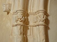
Detail of the entrance portal
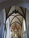
Vault of the main nave

Main altar

Wall painting

Ceiling fresco

Ceiling fresco
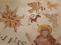
Ceiling fresco in the choir
_-_%C3%89glise_Saint-Jean-Baptiste_de_Larbey.jpg)
.jpg)
.JPG)

.jpg)

.jpg)

_-_%C3%89glise_Saint-Jean-Baptiste_de_Larbey.jpg)
_-_%C3%89glise_Saint-Jean-Baptiste_de_Larbey.jpg)
.jpg)
Watermill

The water mill was built as a permanent house not far from the mouth of the Ruisseau de la Gouaougue in the Louts . It dates from the 12th century and was operated by the English from the 14th century , who had ruled Gascon from that time. It later fell to the Seigneur von Poyaler. In order to protect the valuable goods from thieves and looters, their entrance in particular was heavily fortified. In 1694 the Bénac family had to sell their castle to the Gontaut-Biron family, who originally came from the Béarn . They ruled the region until their last descendant, Charles-Antoine, fled to Spain from the aftermath of the French Revolution in 1792 . Its properties passed to several owners as a national property , but the mill has never been operated again.
Economy and Infrastructure

total = 19
education
The municipality has a public pre-school with 25 students in the 2017/2018 school year.
sport and freetime
A circular path with a length of 9.9 km leads from the center of Larbey through the territory of the municipality.
traffic
Larbey can be reached via Routes départementales 8 and 158.
Web links
- Larbey on the association's website (French)
Individual evidence
- ↑ Landes ( fr ) habitants.fr. Retrieved May 27, 2018.
- ↑ Ma commune: Larbey ( fr ) Système d'Information sur l'Eau du Bassin Adour Garonne. Retrieved May 27, 2018.
- ↑ Toutes les communes fleuries ( fr ) Conseil national des villes et villages fleuris. Retrieved May 27, 2018.
- ↑ Le palmarès landais des villes et villages fleuris 2017 ( fr ) Sud Ouest . May 27, 2018. Retrieved March 14, 2018.
- ↑ a b Raphaël Lamaignère: La Paroisse et l'Église de Larbey ( fr ) 1940. Accessed May 27, 2018.
- ↑ a b Raphael Lamaignère: Le Vieux Larbey ( Fri. ), 1942. Accessed May 27, 2018th
- ^ Notice Communale Larbey ( fr ) EHESS . Retrieved May 27, 2018.
- ↑ Populations légales 2015 Commune de Larbey (40144) ( fr ) INSEE . Retrieved May 27, 2018.
- ^ Eglise Saint-Jean-Baptiste ( fr ) Observatoire du patrimoine religieux. Retrieved May 27, 2018.
- ^ Eglise Saint-Jean-Baptiste ( fr ) Ministry of Culture and Communication . Retrieved May 27, 2018.
- ↑ Caractéristiques des établissements en 2015 Commune de Larbey (40144) ( fr ) INSEE . Retrieved May 27, 2018.
- ^ École maternelle ( fr ) National Ministry of Education. Retrieved May 27, 2018.
- ↑ La boucle de Larbey ( fr ) Visorando. Retrieved May 27, 2018.