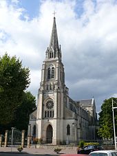
Pontonx-sur-l'Adour
| Pontonx-sur-l'Adour | ||
|---|---|---|
|
|
||
| region | Nouvelle-Aquitaine | |
| Department | Country | |
| Arrondissement | Dax | |
| Canton | Pays Morcenais Tarusate | |
| Community association | Pays Tarusate | |
| Coordinates | 43 ° 47 ′ N , 0 ° 56 ′ W | |
| height | 5–75 m | |
| surface | 49.42 km 2 | |
| Residents | 2,810 (January 1, 2017) | |
| Population density | 57 inhabitants / km 2 | |
| Post Code | 40465 | |
| INSEE code | 40230 | |
| Website | http://www.pontonx.fr/ | |
 Town hall of Pontonx-sur-l'Adour |
||
Pontonx-sur-l'Adour ( Occitan : Pontons ) is a French commune with 2,810 inhabitants (as of January 1, 2017) in the Landes department of the Aquitaine region . It belongs to the Arrondissement Dax and to the cantons of Pays Morcenais Tarusate (until 2015: Canton Tartas-Ouest ).
geography
Pontonx-sur-l'Adour is located on the Adour River , which also forms the eastern municipal boundary. Pontonx-sur-l'Adour is surrounded by the neighboring communities of Laluque in the north and northwest, Bégaar in the northeast, Saint-Jean-de-Lier and Gousse in the east, Préchacq-les-Bains in the south and southeast, Téthieu in the south and southwest as well Saint-Vincent-de-Paul to the west and south-west.
Population development
| year | 1962 | 1968 | 1975 | 1982 | 1990 | 1999 | 2006 | 2012 | |
|---|---|---|---|---|---|---|---|---|---|
| Residents | 1,652 | 1,620 | 1,659 | 1,638 | 1,887 | 2,071 | 2,315 | 2,592 | |
Attractions
- Sainte-Eugénie Church, built in 1879
- Saint-Caprais church
- Pontonx arenas
- Mancamp house from 1610
Web links
Commons : Pontonx-sur-l'Adour - Collection of images, videos and audio files
Individual evidence
- ↑ INSEE ( page no longer available , search in web archives ) Info: The link was automatically marked as defective. Please check the link according to the instructions and then remove this notice.

