
Tilh
| Tilh | ||
|---|---|---|
|
||
| region | Nouvelle-Aquitaine | |
| Department | Country | |
| Arrondissement | Dax | |
| Canton | Orthe et Arrigans | |
| Community association | Pays d'Orthe et Arrigans | |
| Coordinates | 43 ° 35 ′ N , 0 ° 50 ′ W | |
| height | 59-151 m | |
| surface | 22.86 km 2 | |
| Residents | 813 (January 1, 2017) | |
| Population density | 36 inhabitants / km 2 | |
| Post Code | 40360 | |
| INSEE code | 40316 | |
| Website | http://www.tilh.fr/ | |

Tilh is a French municipality with 813 inhabitants (as of January 1 2017) in the department of land in the region Nouvelle-Aquitaine (before 2016: Aquitaine ). It belongs to the arrondissement of Dax and is part of the canton of Orthe et Arrigans (until 2015: canton of Pouillon ).
geography
Tilh is about 15 kilometers southeast of Dax . The Gave de Pau limits the community in the southwest. Habas is surrounded by the neighboring communities of Pomarez in the north, Castel-Sarrazin in the northeast, Arsague in the east, Bonnut in the southeast, Saint-Girons-en-Béarn in the south, Ossages in the southwest and Mouscardès in the west.
Population development
| year | 1962 | 1968 | 1975 | 1982 | 1990 | 1999 | 2006 | 2013 |
| Residents | 818 | 770 | 730 | 794 | 746 | 749 | 813 | 806 |
| Source: Cassini and INSEE | ||||||||
Attractions
- Saint-Pierre-ès-Liens church from the 11th / 12th centuries century
- Villandraut Castle
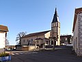
Saint-Pierre-ès-Liens church

Villandraut Castle


Web links
Commons : Tilh - collection of images, videos and audio files