
Maylis
| Maylis | ||
|---|---|---|
|
||
| region | Nouvelle-Aquitaine | |
| Department | Country | |
| Arrondissement | Dax | |
| Canton | Coteau de Chalosse | |
| Community association | Terres de Chalosse | |
| Coordinates | 43 ° 42 ′ N , 0 ° 41 ′ W | |
| height | 43-122 m | |
| surface | 12.21 km 2 | |
| Residents | 315 (January 1, 2017) | |
| Population density | 26 inhabitants / km 2 | |
| Post Code | 40250 | |
| INSEE code | 40177 | |
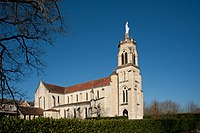
 Notre-Dame Abbey of Maylis |
||

Maylis is a French municipality with 315 inhabitants (at January 1, 2017) in the department of land in the region Nouvelle-Aquitaine (before 2016: Aquitaine ). The municipality belongs to the Arrondissement of Dax and the canton of Coteau de Chalosse (until 2015: canton of Mugron ).
There are several theories about the origin of the name of the community. The most common one sees in the name a combination of the Gascognic word may ( German mother ) with the French word lis ( German lily ), which represents a symbol of purity.
The inhabitants are called Maylisiens and Maylisiennes .
geography
Maylis is located approx. 30 km east of Dax and approx. 25 km southwest of Mont-de-Marsan in the Chalosse region of the historical province of Gascony .
Maylis is surrounded by the neighboring communities:
| Larbey | Saint-Aubin | Montaut |
| Caupenne |
.svg)
|
Doazit |
| Bergouey | Saint-Cricq-Chalosse |
Maylis lies in the catchment area of the Adour River . One of its tributaries, the Louts , flows past the southwestern municipal boundary. Its tributaries Ruisseau de Gaouchard, Ruisseau de la Tuilerie, Ruisseau de Laourole and Ruisseau de la Gouaougue cross the territory of the municipality.
history
By the time the first Christian communities were founded in Gascony at the end of the sixth and during the seventh centuries, Maylis may already have a church. Maylis was first mentioned in a document in 1260. The first reports on pilgrimages in honor of the Virgin Mary did not appear before the 17th century. These reached their peak between 1657 and 1663 when believers attended in large numbers. They were suspended during the French Revolution because numerous pastors who refused to take the oath lived underground. The pilgrimages were resumed in 1877 and have been part of the local tradition ever since. On April 23, 1892, 3,000 farmers gathered to worship Mary for the protection of the harvest. Since then, this common prayer has been repeated every third Sunday after Easter. Another great pilgrimage takes place every year on August 15th on the occasion of the Fête du Lys , one of the most popular festivals in the Landes. The Benedictine monks of the Olivetan Order moved into the Notre-Dame Abbey in 1946 .
Population development
After records began, the population rose to around 570 by the middle of the 19th century. In the period that followed, the size of the community sank with brief recovery phases up to the 1980s to a level of around 330, which has recently fallen below.
| year | 1962 | 1968 | 1975 | 1982 | 1990 | 1999 | 2006 | 2010 | 2017 |
|---|---|---|---|---|---|---|---|---|---|
| Residents | 369 | 369 | 337 | 329 | 338 | 330 | 334 | 340 | 178 |

Attractions
Notre-Dame Abbey

The neo-Gothic abbey church was built in the second half of the 19th century and inaugurated in 1883. It has a plan in the form of a Latin cross . The three-aisled nave opens into a choir in a polygonal apse . The cross arms of the transept are flanked by side chapels and extended by outbuildings. At the western end, the bell tower rises from the vestibule, at the northern corner of which is a narrow round tower. The vestibule has three pointed arched entrance portals with archivolts , at the two outer entrances with overlying rose windows . The facade of the bell tower is interrupted from bottom to top by a twin window , a tower clock and a window with an arched frieze . Arched twin windows and an ocular on each side allow light to enter the bell chamber. The bell tower is closed at the top with a terrace from which a monumental statue of the Virgin Mary rises. Pinnacles decorate the tops of the side buttresses .
Abbey church
Outbuildings


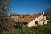
The oldest buildings in the abbey were built at the same time as the abbey church. Before the arrival of the Olivetans, they hosted missionaries from the diocese . The other buildings have only recently been erected. Access to the cloister and the monastery area is reserved for monks .
Former Notre-Dame Church

It was built in the 12th or 13th century as a destination for pilgrimages in honor of Mary. The Romanesque vault probably collapsed when it was rebuilt in Gothic style at the end of the 13th century. During the French Revolution , the chapel was temporarily no longer used, before services were resumed with the Concordat of 1801 . The vault of the current building is ruined. An arcade probably connected the nave with a side chapel. In the bell tower there is an altar for a prayer room, while a wall delimits a second place of prayer in the apse. A two-story tower rises to the west. the ogival entrance is on the north side. The building has been inscribed as a Monument historique since November 2, 1976 . It is privately owned and services are no longer held.
Economy and Infrastructure
Due to the great fertility of its soil in the heart of the Chalosse, the agriculture of Maylis focuses on arable farming, the rearing of ducks and the breeding of cattle for the Course Landaise , a traditional, bloodless game.

total = 52
education
The community has a public preschool and elementary school.
sport and freetime
The regional circular route de la Haute Chalosse also crosses the municipality of Maylis.
traffic
Maylis is crossed by Routes départementales 8 and 18, which connect Maylis with Caupenne and Hagetmau respectively .
Web links
- Maylis on the Association of Municipalities website (French)
- Notre-Dame Abbey website (French)
Individual evidence
- ↑ a b c Maylis ( fr ) Conseil régional d'Aquitaine. Archived from the original on September 12, 2016. Retrieved on August 23, 2018.
- ↑ Landes ( fr ) habitants.fr. Retrieved August 23, 2018.
- ↑ Ma commune: Maylis ( fr ) Système d'Information sur l'Eau du Bassin Adour Garonne. Retrieved August 23, 2018.
- ^ Ancienne église Notre-Dame ( fr ) Ministry of Culture and Communication . Retrieved August 23, 2018.
- ↑ a b Lieux ( fr ) Abbey of Maylis. Retrieved August 23, 2018.
- ↑ Notice Communale Maylis ( fr ) EHESS . Retrieved August 23, 2018.
- ↑ Populations légales 2006 Commune de Maylis (40177) ( fr ) INSEE . Retrieved August 23, 2018.
- ↑ Populations légales 2015 Commune de Maylis (40177) ( fr ) INSEE . Retrieved August 23, 2018.
- ↑ Eglise abbatiale Notre-Dame ( fr ) Observatoire du patrimoine religieux. Retrieved August 23, 2018.
- ^ Ancienne église Notre-Dame ( fr ) Ministry of Culture and Communication . Retrieved August 23, 2018.
- ↑ Ancienne église Notre-Dame ( fr ) Observatoire du patrimoine religieux. Retrieved August 23, 2018.
- ↑ Caractéristiques des établissements en 2015 Commune de Maylis (40177) ( fr ) INSEE . Retrieved August 23, 2018.
- ^ École maternelle et élémentaire ( fr ) National Ministry of Education. Retrieved August 23, 2018.
- ↑ Tour de la Haute Chalosse (Landes) ( fr ) gr-infos.com. Retrieved August 23, 2018.