Arsague
| Arsague | ||
|---|---|---|
|
|
||
| region | Nouvelle-Aquitaine | |
| Department | Country | |
| Arrondissement | Dax | |
| Canton | Coteau de Chalosse | |
| Community association | Coteaux et Vallées des Luys | |
| Coordinates | 43 ° 35 ′ N , 0 ° 48 ′ W | |
| height | 46-94 m | |
| surface | 7.18 km 2 | |
| Residents | 340 (January 1, 2017) | |
| Population density | 47 inhabitants / km 2 | |
| Post Code | 40330 | |
| INSEE code | 40011 | |
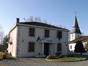
 Town Hall (Mairie) of Arsague |
||
Arsague ( Occitan identical) is a French commune in the department of land in the region Nouvelle-Aquitaine (before 2016 Aquitaine ). The municipality is located in the south of the department and has 340 inhabitants (as of January 1, 2017) and belongs to the canton of Coteau de Chalosse (until 2015 Amou ) within the Dax arrondissement . The inhabitants are called Arsaguais .
geography
Arsague is about 25 kilometers east-southeast of Dax . Arsague is surrounded by the neighboring communities of Castel-Sarrazin in the north, Amou in the east, Bonnut in the south and southeast and Tilh in the west.
population
| year | 1962 | 1968 | 1975 | 1982 | 1990 | 1999 | 2006 | 2013 |
|---|---|---|---|---|---|---|---|---|
| Residents | 403 | 383 | 339 | 289 | 307 | 277 | 299 | 372 |
Attractions
- Saint-Pierre church from the 17th century
- Argoubet Castle
Web links
Commons : Arsague - collection of images, videos and audio files

