Laluque
|
Laluque La Luca |
||
|---|---|---|
|
|
||
| region | Nouvelle-Aquitaine | |
| Department | Country | |
| Arrondissement | Dax | |
| Canton | Pays Morcenais Tarusate | |
| Community association | Pays Tarusate | |
| Coordinates | 43 ° 51 ′ N , 1 ° 0 ′ W | |
| height | 38-86 m | |
| surface | 52.81 km 2 | |
| Residents | 1,019 (January 1, 2017) | |
| Population density | 19 inhabitants / km 2 | |
| Post Code | 40465 | |
| INSEE code | 40142 | |
| Website | http://www.laluque.fr// | |
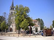
 Center of Laluque |
||
Laluque ( Occitan : La Luca ) is a French commune with 1,019 inhabitants (as of January 1, 2017) in the Landes department of the Aquitaine region . It belongs to the Arrondissement Dax and to the cantons of Pays Morcenais Tarusate (until 2015: Canton Tartas-Ouest ). The inhabitants are called Laluquois .
geography
Laluque is on the Luzou . Laluque is surrounded by the neighboring communities of Rion-des-Landes in the north, Lesgor in the east, Pontonx-sur-l'Adour in the southeast, Saint-Vincent-de-Paul in the south, Gourbera in the southwest and Taller in the west.
Mining
At the beginning of the 20th century, lignite was mined in Laluque, which was brought to the Laluque-Boos and Laluque-Midi stations and to a coal gasification plant by light rail from the Laluque mines .
Population development
| year | 1962 | 1968 | 1975 | 1982 | 1990 | 1999 | 2006 | 2013 | |
|---|---|---|---|---|---|---|---|---|---|
| Residents | 777 | 801 | 715 | 709 | 646 | 610 | 696 | 965 | |
| Source: Cassini and INSEE | |||||||||
Attractions
- Saint-Jean-Baptiste church
Web links
Individual evidence
- ↑ INSEE ( page no longer available , search in web archives ) Info: The link was automatically marked as defective. Please check the link according to the instructions and then remove this notice.


