Cagnotte
|
Cagnotte Canhòta |
||
|---|---|---|
|
|
||
| region | Nouvelle-Aquitaine | |
| Department | Country | |
| Arrondissement | Dax | |
| Canton | Orthe et Arrigans | |
| Community association | Pays d'Orthe et Arrigans | |
| Coordinates | 43 ° 36 ′ N , 1 ° 4 ′ W | |
| height | 12-135 m | |
| surface | 14.68 km 2 | |
| Residents | 760 (January 1, 2017) | |
| Population density | 52 inhabitants / km 2 | |
| Post Code | 40300 | |
| INSEE code | 40059 | |
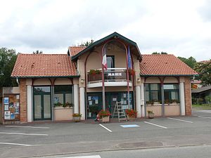
 Town hall (Mairie) of Cagnotte |
||
Cagnotte ( Occitan : Canhota ) is a French municipality with 760 inhabitants (as of January 1 2017) in the department of land in the region Nouvelle-Aquitaine . It belongs to the arrondissement of Dax and is part of the canton of Orthe et Arrigans (until 2015: canton of Pouillon ). The inhabitants are called Labatutois .
geography
Cagnotte is about 15 kilometers south-southwest of Dax on the Via Turonensis , a variant of the Camino de Santiago . Cagnotte is surrounded by the neighboring communities of Heugas in the north, Gaas in the east, Pouillon in the east and southeast, Cauneille in the south, Peyrehorade in the southwest, Bélus in the west and Saint-Lon-les-Mines in the west and northwest.
Population development
| year | 1962 | 1968 | 1975 | 1982 | 1990 | 1999 | 2008 | 2013 |
| Residents | 499 | 457 | 441 | 472 | 506 | 525 | 669 | 759 |
| Source: Cassini and INSEE | ||||||||
Attractions
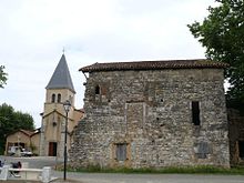
- Notre-Dame church
- Cagnotte Monastery from the 8th century with Notre-Dame church from the 12th century, renovations up to the 15th century, monument historique since 1970
Web links
Commons : Cagnotte - collection of images, videos and audio files

