Hauriet
| Hauriet | ||
|---|---|---|
|
|
||
| region | Nouvelle-Aquitaine | |
| Department | Country | |
| Arrondissement | Dax | |
| Canton | Coteau de Chalosse | |
| Community association | Terres de Chalosse | |
| Coordinates | 43 ° 44 ′ N , 0 ° 42 ′ W | |
| height | 24-106 m | |
| surface | 7.57 km 2 | |
| Residents | 278 (January 1, 2017) | |
| Population density | 37 inhabitants / km 2 | |
| Post Code | 40250 | |
| INSEE code | 40121 | |
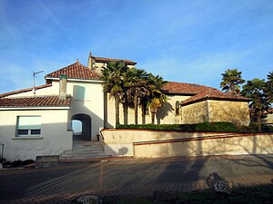
 Saint-Rémy parish church |
||
Hauriet is a French municipality with 278 inhabitants (at January 1, 2017) in the department of land in the region Nouvelle-Aquitaine (before 2016: Aquitaine ). The municipality belongs to the Arrondissement of Dax and the canton of Coteau de Chalosse (until 2015: canton of Mugron ).
The name in the Gascognischen language is also Hauriet . It may have its origin in the word haurie ( German small forge ).
The inhabitants are called Hauriètois and Hauriètoises .
geography
Hauriet is about 30 km east of Dax in the historic province of Gascony .
Hauriet is surrounded by the neighboring communities:
| Nerbis | Toulouzette | |
| Mugron |

|
Montaut |
| Saint-Aubin |
Hauriet is on the left bank of the Adour River .
One of its tributaries, the Gabas , flows along a relatively small section of the northern border with the neighboring municipality of Toulouzette. The Ruisseau de Bazin, a tributary of the Ruisseau de la Gouaougue, crosses the territory of the municipality, as does its tributary, the Ruisseau de Miremon.
history
The origin of the name of the municipality indicates that it was founded and developed on the processing of iron. The community was first mentioned in 1310 in connection with Bernard de Poudenx, the landlord of Hauriet. It is known that Charles de Valois stopped here in 1471 and that the parish church was burned down during the Huguenot Wars in the 16th century. During the French Revolution , the community made a name for itself when the revolutionary Pierre-Arnaud Dartigoeyte sentenced the priest Cabiro to death during the reign of terror . A large part of the area of the municipality is cultivated and until the end of the 19th century the mixed culture allowed the needs of the residents to be met. This was gradually abandoned in favor of the rearing of ducks and geese.
Population development
Hauriet was able to maintain a population of around 500 and more until the end of the 19th century. In the period that followed, the number of inhabitants fell to 240 with short recovery phases by the 1990s, before a moderate growth phase set in, which is still ongoing today.
| year | 1962 | 1968 | 1975 | 1982 | 1990 | 1999 | 2006 | 2010 | 2017 |
|---|---|---|---|---|---|---|---|---|---|
| Residents | 337 | 317 | 285 | 267 | 240 | 251 | 245 | 264 | 278 |
Attractions
Saint-Rémy parish church
It was built in the middle of residential buildings. The nave , on which a side chapel was built on the south side , is extended by a flat apse . To the west, a rectangular bell tower with a gable roof towers over the facade.
Economy and Infrastructure
Agriculture, with a focus on poultry farming, is the municipality's most important economic factor.

total = 32
education
The municipality has a public pre-school with 21 students in the 2017/2018 school year.
sport and freetime
The green path ( Voie verte ) from the gates of Dax to shortly before Saint-Sever also leads through the northern municipality of Hauriet. It is a former railway line of the Compagnie des Tramways à Vapeur de la Chalosse et du Béarn , which opened in 1899. At the end of the 1930s the transport of people was stopped, the freight transport only in 1970. The rails were removed and made space for pedestrians, cyclists and riders.
traffic
Hauriet can be reached via Routes départementales 8, 18 and 32.
Web links
- Hauriet on the association's website (French)
Individual evidence
- ↑ Hauriet ( fr ) Gasconha.com. Retrieved May 1, 2018.
- ↑ a b c Hauriet ( fr ) Conseil régional d'Aquitaine. Archived from the original on September 9, 2016. Retrieved on May 1, 2018.
- ↑ Landes ( fr ) habitants.fr. Retrieved May 1, 2018.
- ↑ Ma commune: Hauriet ( fr ) Système d'Information sur l'Eau du Bassin Adour Garonne. Retrieved May 1, 2018.
- ↑ Notice Communale Hauriet ( fr ) EHESS . Retrieved May 1, 2018.
- ↑ Populations légales 2015 Commune d'Hauriet (40121) ( fr ) INSEE . Retrieved May 1, 2018.
- ^ Eglise Saint-Rémy ( fr ) Observatoire du patrimoine religieux. Retrieved May 1, 2018.
- ↑ Caractéristiques des établissements en 2015 Commune d'Hauriet (40121) ( fr ) INSEE . Retrieved May 1, 2018.
- ^ École maternelle ( fr ) National Ministry of Education. Retrieved May 1, 2018.
- ↑ Voie verte de Chalosse ( fr ) Terres de Chalosse Tourist Office . Retrieved May 1, 2018.


