
Oeyregave
|
Oeyregave Ueire Gave |
||
|---|---|---|
|
||
| region | Nouvelle-Aquitaine | |
| Department | Country | |
| Arrondissement | Dax | |
| Canton | Orthe et Arrigans | |
| Community association | Pays d'Orthe et Arrigans | |
| Coordinates | 43 ° 33 ′ N , 1 ° 6 ′ W | |
| height | 1–106 m | |
| surface | 13.94 km 2 | |
| Residents | 344 (January 1, 2017) | |
| Population density | 25 inhabitants / km 2 | |
| Post Code | 40300 | |
| INSEE code | 40206 | |

Oeyregave ( Occitan Ueire Gave ) is a French municipality with 344 inhabitants (at January 1, 2017) in the department of land in the region Nouvelle-Aquitaine (before 2016 Aquitaine ) in southwestern France. It belongs to the Arrondissement of Dax and the canton of Orthe et Arrigans (until 2015 Peyrehorade ).
geography
Oeyregave is located on the Gaves Réunis river around 40 kilometers east-northeast of Bayonne . Neighboring communities are Peyrehorade in the north, Cauneille in the northeast, Sorde-l'Abbaye in the east, Came in the south and Hastingues in the west and southwest.
Population development
| year | 1962 | 1968 | 1975 | 1982 | 1990 | 1999 | 2006 | 2013 |
| Residents | 344 | 425 | 402 | 350 | 289 | 293 | 317 | 354 |
| Source: Cassini and INSEE | ||||||||
Attractions
- Notre-Dame church
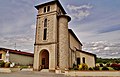
Notre-Dame church


Interior of the church


Web links
Commons : Oeyregave - collection of images, videos and audio files