Gourbera
|
Gourbera Gorberar |
||
|---|---|---|
|
|
||
| region | Nouvelle-Aquitaine | |
| Department | Country | |
| Arrondissement | Dax | |
| Canton | Dax-1 | |
| Community association | Grand Dax | |
| Coordinates | 43 ° 48 ′ N , 1 ° 3 ′ W | |
| height | 26-84 m | |
| surface | 27.73 km 2 | |
| Residents | 372 (January 1, 2017) | |
| Population density | 13 inhabitants / km 2 | |
| Post Code | 40990 | |
| INSEE code | 40114 | |
| Website | http://www.mairie-gourbera.fr/ | |
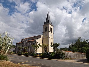
 Parish Church of Saint-André |
||
Gourbera ( Occitan : Gorberar ) is a French municipality with 372 inhabitants (as of January 1 2017) in the department of land in the region Nouvelle-Aquitaine . Gourbera is part of the Dax arrondissement and the Dax-1 canton (until 2015: Dax-Nord canton ). The inhabitants are called Gourberasiens .
geography
Gourbera is in the Marensin countryside . Gourbera is surrounded by the neighboring communities of Taller in the north, Laluque in the north-east, Saint-Vincent-de-Paul in the east and south-east, Saint-Paul-lès-Dax in the south, Herm in the west and Castets in the north-west.
history
In 1985 remains of Roman ceramics with 620 bronze pieces from the 4th century were discovered in Gourbera.
Population development
| 1962 | 1968 | 1975 | 1982 | 1990 | 1999 | 2006 | 2010 | 2017 |
|---|---|---|---|---|---|---|---|---|
| 198 | 179 | 197 | 215 | 243 | 256 | 252 | 356 | 372 |
| Source: Cassini and INSEE | ||||||||
Attractions
- Saint-André church
Web links
Commons : Gourbera - collection of images, videos and audio files
