Poyartin
|
Poyartin Poi Artin |
||
|---|---|---|
|
|
||
| region | Nouvelle-Aquitaine | |
| Department | Country | |
| Arrondissement | Dax | |
| Canton | Coteau de Chalosse | |
| Community association | Terres de Chalosse | |
| Coordinates | 43 ° 41 ′ N , 0 ° 52 ′ W | |
| height | 17-102 m | |
| surface | 13.04 km 2 | |
| Residents | 833 (January 1, 2017) | |
| Population density | 64 inhabitants / km 2 | |
| Post Code | 40380 | |
| INSEE code | 40236 | |
| Website | http://perso.orange.fr/mairie-poyartin/ | |
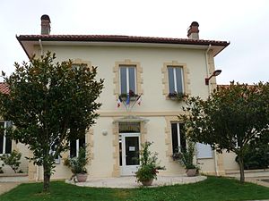
 Town Hall (Mairie) of Poyartin |
||
Poyartin ( Occitan : Poi Artin ) is a French municipality with 833 inhabitants (as of January 1 2017) in the Landes department in the region Nouvelle-Aquitaine (before 2016: Aquitaine ). It belongs to the Arrondissement of Dax and the canton of Coteau de Chalosse (until 2015: canton of Montfort-en-Chalosse ). The residents call themselves Poyartinois .
geography
Poyartin is located in the Marensin countryside on the edge of the vast Landes de Gascogne , the largest forest area in Western Europe, about 14 kilometers east-southeast of Dax . Poyartin is surrounded by the neighboring communities of Gamarde-les-Bains in the north, Montfort-en-Chalosse in the east and northeast, Gibret in the east, Donzacq in the southeast, Castelnau-Chalosse in the south, Ozourt and Garrey in the southwest, Sort-en-Chalosse in the West as well as Hinx to the west and northwest.
| Population development | |||||||||
|---|---|---|---|---|---|---|---|---|---|
| year | 1962 | 1968 | 1975 | 1982 | 1990 | 1999 | 2006 | 2010 | 2017 |
| Residents | 656 | 623 | 629 | 631 | 648 | 631 | 643 | 754 | 833 |
Attractions
- Saint-Barthélémy church from the 14th century, monument historique
- Domain of Labouran


