Eyres-Moncube
| Eyres-Moncube | ||
|---|---|---|
|
|
||
| region | Nouvelle-Aquitaine | |
| Department | Country | |
| Arrondissement | Mont-de-Marsan | |
| Canton | Chalosse Tursan | |
| Community association | Chalosse Tursan | |
| Coordinates | 43 ° 43 ′ N , 0 ° 33 ′ W | |
| height | 44-122 m | |
| surface | 12.19 km 2 | |
| Residents | 365 (January 1, 2017) | |
| Population density | 30 inhabitants / km 2 | |
| Post Code | 40500 | |
| INSEE code | 40098 | |
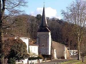
 View of the center of Eyres-Moncube |
||
Eyres-Moncube is a French commune of 365 inhabitants (at January 1, 2017) in the department of land in the region Nouvelle-Aquitaine (before 2016: Aquitaine ). The municipality belongs to the arrondissement of Mont-de-Marsan and the canton of Chalosse Tursan (until 2015: canton of Saint-Sever ).
There are many possible explanations for the origin of the name Eyres. It could come from the Greek word Eyros ( German wool ), from Ayre ( German threshing floor ) or a diminutive of the name of the Leyre, a river in the country.
The inhabitants are called Eyrois and Eyroises .
geography
Eyres-Moncube is located about 20 kilometers south of Mont-de-Marsan in the Tursan region of the historic province of Gascony .
Eyres-Moncube is surrounded by the neighboring communities:
| Saint-Sever | Montsoué | |
|
Audignon dumes |

|
Sarraziet |
| Sainte-Colombe | Coudures |
Eyres-Moncube lies in the catchment area of the Adour River .
One of its tributaries, the Gabas , irrigates the municipality as does its tributaries, the Bas and the Ruisseau de Pichegarie.
history
In 1907 the Roman military camp "Casterot de la Salle" was discovered on the territory of the municipality. In 1846 the previously independent municipalities of Eyres and Moncube were combined to form the new municipality of Eyres-Moncube. On the left bank of the Gabas was Eyres, a former fiefdom of the Baronate of Hagetmau . Moncube on the right bank has belonged to the Benedictines from Saint-Sever since the Middle Ages . In the 19th century, the residents lived from agriculture and cattle breeding. At that time there was also a tailor, a clog maker, a blacksmith and a manufacturer of carts and plows, a wheelwright . There were also numerous Meierhöfe in the municipality, which gradually disappeared in the 20th century.
Population development
With the amalgamation of the two former municipalities Eyres and Moncube, the new municipality had a high of around 750 inhabitants. As a result, Eyres-Moncube's size decreased to around 300 residents by the 1980s, with short recovery periods, before moderate growth began that continues to this day.
| year | 1962 | 1968 | 1975 | 1982 | 1990 | 1999 | 2006 | 2010 | 2017 |
|---|---|---|---|---|---|---|---|---|---|
| Residents | 400 | 386 | 331 | 301 | 317 | 342 | 368 | 375 | 365 |
Attractions
Saint-Barthélémy parish church
The first, simple church was built in the 12th century. Through alterations and additions over the centuries, it now shows a mixture of Romanesque and Gothic style elements. Your nave with three naves is extended with a semicircular choir , which is illuminated through three arched windows. The sacristy is attached to the south of the apse . The walls of the nave are interrupted by arched windows that alternate with the buttresses on the outside . In the west, the massive bell tower overlooks the vestibule, which opens up via an arcade in the form of a pointed arch on its north side. Defensive elements such as loopholes can still be seen on the tower today . A polygonal helmet covered with slate rises up on his tent roof .
Church of the Notre-Dame de Saint-Eustase Abbey
The Eyres-Moncube Benedictine Abbey was built in 1988 according to plans by the architect Jacques de Saint-Rapt. Its square bell tower rises in the middle of the building above the chancel. Likewise, the main altar is not in the semicircular apse, as usual, but in the nave. The reason for this unusual division is that the nuns live here in seclusion. The western part of the church with the main entrance is open to the public, the eastern part is reserved for nuns. The stained glass windows are the work of the master glass painter Lestienne from Tarbes .
Burial chapel of General Jean Maximilien Lamarque
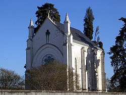
Jean Maximilien Lamarque (1770-1832) was a general during the Napoleonic Wars and later a member of the French parliament. His family came from the neighboring parish of Saint-Sever. After his death, the burial chapel was built where he was buried.
Laféourère Castle
It was built in 1810 on a hill above the Gabas valley and given to the Benedictine abbey of Saint-Eustase. It consists of a two-story residential building with a hipped roof . A triangular gable marks the center of the facade. A slender, round tower is attached to one of the side facades. The building exudes a certain objectivity. The castle is privately owned and is not open to the public.
Watermill
It dates from the 16th century and is one of the oldest preserved watermills in the department. The building and the inlet from the gabas are in good condition.
Economy and Infrastructure
One of the most important economic factors of the municipality remains agriculture with its traditional cattle breeding, but also with a diversification towards poultry farming of ducks and geese and the cultivation of maize.
Eyres-Moncube is located in the AOC zone of the Tursan wine region .

total = 40
education
The community has a public primary school with 43 pupils in the 2017/2018 school year.
sport and freetime
A circular path with a length of 14.2 km leads from the center through the area of the municipality u. a. past the Notre-Dame de Saint-Eustase Abbey and the burial chapel of General Jean Maximilien Lamarque.
traffic
Eyres-Moncube can be reached via Routes départementales 350E, 933S (former Route nationale 133 ) and 944 (former Route nationale 644 ).
Web links
- Eyres-Moncube on the Association of Municipalities website (French)
- Eyres-Moncube on the website of the former municipal association (French)
- Website of the Association Qualité Landes with information on Tursan wine (French)
Individual evidence
- ↑ a b c Eyres-Moncube ( fr ) Conseil régional d'Aquitaine. Archived from the original on September 9, 2016. Retrieved on April 3, 2018.
- ↑ Landes ( fr ) habitants.fr. Retrieved April 3, 2018.
- ↑ Ma commune: Eyres-Moncube ( fr ) Système d'Information sur l'Eau du Bassin Adour Garonne. Retrieved April 3, 2018.
- ↑ Notice Communale Eyres-Moncube ( fr ) EHESS . Retrieved April 3, 2018.
- ↑ Populations légales 2006 Commune d'Eyres-Moncube (40098) ( fr ) INSEE . Retrieved April 3, 2018.
- ↑ Populations légales 2015 Commune d'Eyres-Moncube (40098) ( fr ) INSEE . Retrieved April 3, 2018.
- ↑ Eglise Saint-Barthélémy ( fr ) Observatoire du patrimoine religieux. Retrieved April 3, 2018.
- ↑ Eglise de l'abbaye Notre-Dame-de-Saint-Eustase ( fr ) Observatoire du patrimoine religieux. Retrieved April 3, 2018.
- ↑ Chapelle funéraire du général Lamarque ( fr ) Observatoire du patrimoine religieux. Retrieved April 3, 2018.
- ↑ Château de Laféourère ( fr ) chateau-fort-manoir-chateau.eu. Retrieved April 3, 2018.
- ↑ SIN0000278 - Moulin de Gabas ( fr ) Region Nouvelle Aquitaine. Retrieved April 3, 2018.
- ↑ Institut national de l'origine et de la qualité: Rechercher un produit ( fr ) Institut national de l'origine et de la qualité . Retrieved April 3, 2018.
- ↑ Caractéristiques des établissements en 2015 Commune d'Eyres-Moncube (40098) ( fr ) INSEE . Retrieved April 3, 2018.
- ^ École élémentaire ( fr ) National Ministry of Education. Retrieved April 3, 2018.
- ↑ A Eyres-Moncube, circuit du Pouy de Montsoué et de la vallée du Gabas ( fr ) Comité Départemental du Tourisme. Retrieved April 3, 2018.


