
Cazères-sur-l'Adour
| Cazères-sur-l'Adour | ||
|---|---|---|
|
||
| region | Nouvelle-Aquitaine | |
| Department | Country | |
| Arrondissement | Mont-de-Marsan | |
| Canton | Adour Armagnac | |
| Community association | Pays Grenadois | |
| Coordinates | 43 ° 46 ′ N , 0 ° 19 ′ W | |
| height | 62-139 m | |
| surface | 31.25 km 2 | |
| Residents | 1,070 (January 1, 2017) | |
| Population density | 34 inhabitants / km 2 | |
| Post Code | 40270 | |
| INSEE code | 40080 | |

Cazères-sur-l'Adour ( Occitan : caseras d'Ador ) is a French municipality with 1070 inhabitants (as of January 1 2017) in the department of land in the region Nouvelle-Aquitaine (before 2016: Aquitaine ). The municipality belongs to the arrondissement of Mont-de-Marsan and the canton of Adour Armagnac (until 2015: canton of Grenade-sur-l'Adour ). The inhabitants are called Cazèriens .
geography
Cazères-sur-l'Adour is located about 20 kilometers south-east of Mont-de-Marsan on the Adour , which borders the municipality in the south and south-west. Cazères-sur-l'Adour is surrounded by the neighboring communities of Hontanx and Le Vignau in the north, Lussagnet in the northeast, Le Houga in the east, Aire-sur-l'Adour in the south and southeast, Duhort-Bachen in the south, Renung in the west and Southwest, Bordères-et-Lamensans in the west and Castandet in the northwest.
The A65 autoroute runs through the municipality .
history
The municipality was founded in 1314 as a bastide by the vice counts of Béarn.
Population development
| 1962 | 1968 | 1975 | 1982 | 1990 | 1999 | 2006 | 2013 |
|---|---|---|---|---|---|---|---|
| 676 | 766 | 777 | 815 | 873 | 862 | 1,132 | 1,093 |
| Source: Cassini and INSEE | |||||||
Attractions
- Saint Barthélemy Church
- Steel bridge over the Adour, built by Gustave Eiffel, monument historique since 2000
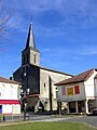
Saint Barthélemy Church

Bridge over the Adour

