Solférino (Landes)
|
Solférino Vilanava de la Bohèira |
||
|---|---|---|
|
|
||
| region | Nouvelle-Aquitaine | |
| Department | Country | |
| Arrondissement | Mont-de-Marsan | |
| Canton | Haute Lande Armagnac | |
| Community association | Cœur Haute Lande | |
| Coordinates | 44 ° 9 ′ N , 0 ° 55 ′ W | |
| height | 74-85 m | |
| surface | 97.83 km 2 | |
| Residents | 324 (January 1, 2017) | |
| Population density | 3 inhabitants / km 2 | |
| Post Code | 40210 | |
| INSEE code | 40303 | |
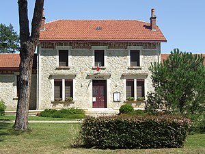
 Solférino Town Hall |
||
Solférino ( Occitan : Vilanava de la Bohèira or Solfrin ) is a French municipality with 324 inhabitants (as of January 1 2017) in the department of land in the region Nouvelle-Aquitaine (2015: Aquitaine ). Solférino belongs to the arrondissement of Mont-de-Marsan and is part of the canton of Haute Lande Armagnac (until 2015: canton of Sabers ).
geography
Solférino is located about 50 kilometers northwest of Mont-de-Marsan and about 24 kilometers east of the Atlantic coast. Solférino is surrounded by the neighboring communities of Labouheyre in the north, Commensacq in the north-east, Sabers in the east, Morcenx-la-Nouvelle in the south and south-east, Sindères in the south-west, Onesse-Laharie in the west and south-west, Escource in the west and Lüe in the north-west.
history
In 1863 the community was formed. It got its current name based on the Italian battle site ( Battle of Solferino ).
Population development
| year | 1962 | 1968 | 1975 | 1982 | 1990 | 1999 | 2006 | 2013 |
| Residents | 418 | 447 | 486 | 414 | 403 | 348 | 350 | 346 |
| Source: Cassini and INSEE | ||||||||
Attractions
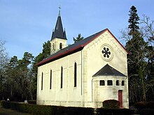
- Sainte-Eugenie church
- Pouy Manor, built in 1857, a historic monument since 2010
Parish partnership
A partnership has existed with the Italian municipality of Solferino in Lombardy since 1963.

