Read
| Read | ||
|---|---|---|
|
|
||
| region | Nouvelle-Aquitaine | |
| Department | Country | |
| Arrondissement | Mont-de-Marsan | |
| Canton | Haute Lande Armagnac (main town) | |
| Community association | Cœur Haute Lande | |
| Coordinates | 44 ° 8 ′ N , 0 ° 30 ′ W | |
| height | 88-123 m | |
| surface | 51.10 km 2 | |
| Residents | 227 (January 1, 2017) | |
| Population density | 4 inhabitants / km 2 | |
| Post Code | 40420 | |
| INSEE code | 40297 | |
 Le Sen town hall |
||
Le Sen is a French municipality with 227 inhabitants (at January 1, 2017) in the department of land in the region Nouvelle-Aquitaine (before 2016: Aquitaine ). It belongs to the arrondissement of Mont-de-Marsan and the canton of Haute Lande Armagnac (until 2015: canton of Labrit ).
The name in the Gascognischen language is Eussen , whose origin is unclear.
The inhabitants are called Sennois and Sennoises .
geography
Le Sen is about 30 km north of Mont-de-Marsan in the historic province of Gascony .
Le Sen is surrounded by the neighboring communities:
| Luxey | ||

|
Lencouacq | |
| Labrite | Cache |
Le Sen is located in the catchment area of the Adour River .
The Estrigon , a right tributary of the Midouze , rises on the territory of the municipality.
history
A member of the noble Albret family probably founded a priory in Le Sen in the middle of the 13th century . It comprised the hospital , outbuildings, lands and farms and was given to the Bishop of Bethlehem to support the Crusades . A chapel dedicated to Mary was built for the occasion. After the crusades, the priory was subordinate to the Albrets, who even nominated the priors themselves. After the Albrets converted to Protestantism , the priory served as a place of refuge and was to be destroyed at the behest of the French king. But Cardinal de Sourdis, Archbishop of Bordeaux , preserved the priory and added it to his possessions. During the French Revolution , the priory was sold as a national good. It served as a hostel until its demolition in 1935.
Le Sen owned a station on the railway line that connected Mont-de-Marsan to Luxey and opened in 1906. In 1955 the transport of people was stopped, in 1959 the freight transport.
Population development
After records began, the population rose to a peak of 525 by the middle of the 19th century. In the following period, the size of the community decreased with brief recovery phases, especially during the 20th century until the 1970s, to around 125 inhabitants before a growth phase began, which continues today.
| year | 1962 | 1968 | 1975 | 1982 | 1990 | 1999 | 2006 | 2010 | 2017 |
|---|---|---|---|---|---|---|---|---|---|
| Residents | 189 | 182 | 127 | 127 | 161 | 201 | 205 | 207 | 227 |
Attractions
Parish Church of Notre-Dame du Mont-Carmel
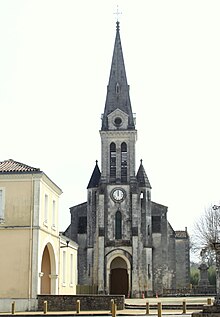
The church was originally the chapel of the priory and probably belonged to the parish of Labrit since the 14th century. During the Huguenot Wars in 1649 it was plundered and devastated by Protestant troops under the command of Captain Lubardes, and later again by the troops of Captain Cardonne from Saint-Sever , who brought down the southern wall. The building was restored from 1650, a few decades after the priory had merged with Notre-Dame de la Miséricorde de la Chartreuse in Bordeaux. Only parts of the walls of the nave and the former choir can be seen of this building with a single nave long house , which was preceded by a bell gable with a stair tower . In 1791 the church was sold together with the priory to the Baron von Poyferré de Cère. After the Concordat of 1801 it was made available again for church services and then bought back by the community. In 1867 an extensive restoration began, which is equivalent to a new building under the direction of the architect of the department, Alexandre Ozanne. The work included the construction of a new, square choir, two side chapels forming a transept, and a sacristy to the south of the choir . The project ended in 1870 with a complete redesign of the windows and entrances and the construction of a large bell tower , which was not included in the original plan. The church is now in a neo-Gothic style with a nave with a length of three bays . The bell tower houses the vestibule on the ground floor and a gallery on the first floor . It is lined with two octagonal stair towers. The nave and choir are equipped with a false groin vault , which rests on projections in the nave and in the chapels, and in the choir on battlements . Gable roofs with hollow tiles cover the nave and the chapels, the square helmet and the polygonal roofs of the stair towers are bricked. Sloping buttresses surround the entire building. The church was consecrated on April 27, 1870.
The church, looted in 1649, was probably rebuilt in the second half of the 17th century during reconstruction. From the time of the Ancien Régime , however, only a large wooden statue with the representation of Mary with child Jesus has survived, which dates from the end of the 17th or the beginning of the 18th century. The flat back of the 1.40 m tall figure suggests that it was originally intended for a niche in an altarpiece . In the middle of the 19th century, and especially with the new building in 1867, elements of the church furnishings were replaced. A glass window is a work of glass artist Gustave Pierre DAGRANT of Bayonne , which was created 1869th It consists of three lancets, the middle one higher than the other two. The middle lancet shows a praying Jesus Christ with a chalice and a host , the left John the Baptist with a lamb, the right Saint Blaise of Sebaste as a bishop with a crook and a martyr's palm . The people are depicted upright against a red background in multi-pass medallions . The described and many other items of equipment of the church are registered as national cultural assets.
Economy and Infrastructure
The BIOLANDES company is located in the municipality. It was founded in 1980 and distills ingredients from pine trees for the perfume industry. The waste products are processed to fertilize gardens and used to generate energy.

total = 39
education
The community has a public primary school with 41 pupils in the 2017/2018 school year.
sport and freetime
- Le Sen is located in the Landes de Gascogne Regional Nature Park .
- An easy circular route with a length of 46 km leads from the center of Le Sen by bike in the footsteps of pilgrims and shepherds past the sights of Le Sen and its neighboring communities.
traffic
Le Sen can be reached via Routes départementales 9, 392 626 and 651.
Web links
- Le Sen on the association's website (French)
- Landes de Gascogne Regional Nature Park website (French)
- BIOLANDES website (French)
Individual evidence
- ↑ Le Sen ( fr ) Gasconha.com. Retrieved June 9, 2018.
- ↑ Landes ( fr ) habitants.fr. Retrieved June 9, 2018.
- ↑ Ma commune: Le Sen ( fr ) Système d'Information sur l'Eau du Bassin Adour Garonne. Retrieved June 9, 2018.
- ↑ Le Sen ( fr ) Communauté de communes Cœur Haute Lande. Retrieved June 9, 2018.
- ↑ Description of the line Luxey / Mont-de-Marsan ( fr ) Voies ferrées des Landes. Retrieved June 23, 2018.
- ^ Notice Communale Le Sen ( fr ) EHESS . Retrieved June 9, 2018.
- ↑ Populations légales 2006 Commune du Sen (40297) ( fr ) INSEE . Retrieved June 9, 2018.
- ↑ Populations légales 2015 Commune du Sen (40297) ( fr ) INSEE . Retrieved June 9, 2018.
- ↑ église paroissiale Notre-Dame du Mont-Carmel ( fr ) Ministry of Culture and Communication . Retrieved June 9, 2018.
- ↑ le mobilier de l'église paroissiale Notre-Dame du Mont-Carmel ( fr ) Ministry of Culture and Communication . Retrieved June 9, 2018.
- ↑ statue: Vierge à l'Enfant ( fr ) Ministry of Culture and Communication . Retrieved June 9, 2018.
- ↑ verrière: prêtre Le Christ, saint Jean-Baptiste et saint Blaise (baie 0) ( fr ) Ministry of Culture and Communication . Retrieved June 9, 2018.
- ↑ Usine biolandes ( fr ) Regional Natural Park of the Landes de Gascogne. Retrieved June 9, 2018.
- ↑ Caractéristiques des établissements en 2015 Commune du Sen (40297) ( fr ) INSEE . Retrieved June 9, 2018.
- ^ École élémentaire ( fr ) National Ministry of Education. Retrieved June 9, 2018.
- ↑ 51 communes du Parc Naturel Regional des Landes de Gascogne ( fr , PDF) Parc Naturel Régional des Landes de Gascogne. Archived from the original on March 3, 2016. Info: The archive link was inserted automatically and has not yet been checked. Please check the original and archive link according to the instructions and then remove this notice. Retrieved June 9, 2018.
- ^ A Le Sen, sur les pas des pèlerins et des bergers ( fr ) Parc naturel regional des Landes de Gascogne. Retrieved June 9, 2018.


