
Lucbardez-et-Bargues
|
Lucbardez-et-Bargues Luc-Bardès |
||
|---|---|---|
|
||
| region | Nouvelle-Aquitaine | |
| Department | Country | |
| Arrondissement | Mont-de-Marsan | |
| Canton | Mont-de-Marsan-1 | |
| Community association | Mont-de-Marsan agglomeration | |
| Coordinates | 43 ° 58 ′ N , 0 ° 24 ′ W | |
| height | 38-97 m | |
| surface | 21.48 km 2 | |
| Residents | 573 (January 1, 2017) | |
| Population density | 27 inhabitants / km 2 | |
| Post Code | 40090 | |
| INSEE code | 40162 | |
 town hall |
||

Lucbardez-et-Bargues is a French municipality with 573 inhabitants (at January 1, 2017) in the department of land in the region Nouvelle-Aquitaine (before 2016: Aquitaine ). The municipality belongs to the arrondissement of Mont-de-Marsan and the canton of Mont-de-Marsan-1 (until 2015: canton of Mont-de-Marsan-Nord ).
The name in the Gascognischen language is Luc-Bardès . It is derived from the Latin locus meaning "holy forest".
The inhabitants are called Lucbardéziens and Lucbardéziennes .
geography
Lucbardez-et-Bargues is located about 15 km northeast of Mont-de-Marsan in the Pays de Marsan region of the historic province of Gascony on the southeastern edge of the department.
Lucbardez-et-Bargues is surrounded by the neighboring municipalities:
| Maillères | Pouydesseaux | |
| Canenx-et-Réaut |
.svg)
|
Bostens |
| Saint-Avit | Gaillères |
Lucbardez-et-Bargues lies in the catchment area of the Adour River .
The Douze crosses the territory of the municipality as well as its tributaries,
- the Ruisseau des Neuf Fontaines,
- the Ruisseau de l'Eglise, which rises in Lucbardez-et-Bargues,
- the Ruisseau du Cohe, also called Ruisseau du loup and which rises in Lucbardez-et-Bargues, and
- the Ruisseau du Roumat, which also rises in Lucbardez-et-Bargues.
history
After its foundation during the French Revolution , the municipality's toponyms were initially Luc Bardes in 1792 and Lucbardes in 1801. In 1827 the municipality of Barques was annexed to the municipality, whose name was henceforth Lucbardez-et-Bargues.
Population development
After the merger of the two former communities, the population fluctuated between the middle of the 19th century and the beginning of the 19th century between 500 and 585. In the following period, the size of the community fell to 230 inhabitants before the 1970s, with short recovery phases an initially moderate growth set in, but recently also strong growth.
| year | 1962 | 1968 | 1975 | 1982 | 1990 | 1999 | 2006 | 2010 | 2017 |
|---|---|---|---|---|---|---|---|---|---|
| Residents | 311 | 273 | 230 | 269 | 304 | 327 | 374 | 507 | 573 |

Attractions
Parish church of Sainte-Quitterie

The apse of the holy Quiteria church dates back to the 12th century Romanesque . It is equipped with cut stones from limestone in the middle brickwork built. Two narrow columns on a stylobate support its wall and run towards ornate capitals . These carry a three-row roller frieze supported by very blunt brackets . In the curve of the apse there are three small arched windows, the middle one narrower than the other two. A semicircular bell tower was built on top of the apse at a later date. At its top, a colonnade is built into a rotunda that houses the bells. The rest of the building is the result of recent construction. It hides a single nave nave with arched windows. The southern wall is interrupted on the outside for the spring, which is dedicated to the patron saint of the church, St. Quiteria. There is a round arch portal on the west facade , which is supported by wall columns. Above that, an oculus lets light into the interior of the church.
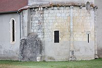
apse

Capital with scroll frieze on the apse


Economy and Infrastructure
Trade and services are the main economic drivers of the community.

total = 34
education

The municipality has a public primary school with 46 pupils in the 2017/2018 school year.
traffic
Lucbardez-et-Bargues is crossed by Routes départementales 392 and 934, the former Route nationale 132 .
The Autoroute A65 , called Autoroute de Gascogne , crosses the municipality. Your exit 4 is partly on the territory of the municipality.
Web links
Individual evidence
- ↑ Lucbardez-et-Bargues ( fr ) Gasconha.com. Retrieved July 12, 2018.
- ↑ Landes ( fr ) habitants.fr. Retrieved July 12, 2018.
- ↑ Ma commune: Lucbardez-et-Bargues ( fr ) Système d'Information sur l'Eau du Bassin Adour Garonne. Retrieved July 12, 2018.
- ↑ a b Notice Communale Lucbardez-et-Bargues ( fr ) EHESS . Retrieved July 12, 2018.
- ↑ Populations légales 2015 Commune de Lucbardez-et-Bargues (40162) ( fr ) INSEE . Retrieved July 12, 2018.
- ↑ Eglise Sainte-Quitterie ( fr ) Observatoire du patrimoine religieux. Retrieved July 12, 2018.
- ↑ Caractéristiques des établissements en 2015 Commune de Lucbardez-et-Bargues (40162) ( fr ) INSEE . Retrieved July 12, 2018.
- ^ École élémentaire ( fr ) National Ministry of Education. Retrieved July 12, 2018.