Labouheyre
|
Labouheyre La Bohèira |
||
|---|---|---|

|
|
|
| region | Nouvelle-Aquitaine | |
| Department | Country | |
| Arrondissement | Mont-de-Marsan | |
| Canton | Haute Lande Armagnac | |
| Community association | Cœur Haute Lande | |
| Coordinates | 44 ° 13 ′ N , 0 ° 55 ′ W | |
| height | 57-84 m | |
| surface | 36.13 km 2 | |
| Residents | 2,731 (January 1, 2017) | |
| Population density | 76 inhabitants / km 2 | |
| Post Code | 40210 | |
| INSEE code | 40134 | |
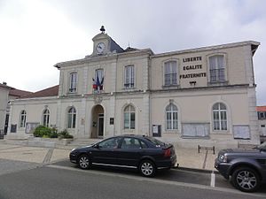
 Labouheyre Town Hall |
||
Labouheyre ( Occitan : La Bohèira , including La Havoèrade ) is a French municipality with 2,731 inhabitants (as of January 1 2017) in the department of land in the region Nouvelle-Aquitaine . Labouheyre belongs to the arrondissement of Mont-de-Marsan and is part of the canton of Haute Lande Armagnac . The inhabitants are called Bouheyrot (e) s .
geography
Labouheyre is located about 50 kilometers northwest of Mont-de-Marsan and about 30 kilometers east of the Atlantic coast. Labouheyre is surrounded by the neighboring communities of Pissos in the north and northeast, Commensacq in the east, Solférino in the south, Lüe in the west and Ychoux in the northwest.
The A63 autoroute and the former National Route 10 run through the municipality . Labouheyre is on the Via Turonensis of the Camino de Santiago .
Population development
| year | 1962 | 1968 | 1975 | 1982 | 1990 | 1999 | 2006 | 2011 |
| Residents | 2,169 | 2,314 | 2,649 | 2,849 | 2,816 | 2,534 | 2,507 | 2,628 |
Parish partnership
A partnership has existed with the Portuguese municipality of Gouveia since 1987 .
Attractions
- Saint-Jacques church, built in the late 15th, early 16th centuries
- House Félix Arnaudin
- old post office
- Lake in Peyre Park
Personalities
- Félix Arnaudin (1844–1921), photographer and writer

