
Klein-Umstadt
|
Klein-Umstadt
City of Groß-Umstadt
|
|
|---|---|
 |
|
| Height : | 181 m above sea level NHN |
| Area : | 9.8 km² |
| Residents : | 2094 (Dec 2016) |
| Population density : | 214 inhabitants / km² |
| Incorporation : | January 1, 1977 |
| Postal code : | 64823 |
| Area code : | 06078 |
 Location of Klein-Umstadt in Groß-Umstadt
|
|
Klein-Umstadt is a district of Groß-Umstadt in the eastern part of the Darmstadt-Dieburg district in southern Hesse on the northern edge of the Odenwald . Of the eight formerly independent communities that were affiliated to the city of Groß-Umstadt between 1971 and 1977 as part of the regional reform in Hesse , Klein-Umstadt is the largest urban district in terms of population.
geography

location
Klein-Umstadt is located on the northern edge of the low mountain range Odenwald in a flat hollow of the loess area, about 40 km southeast of Frankfurt am Main and about halfway between Darmstadt and Aschaffenburg in Lower Franconia . The formerly independent village is now inhabited by approx. 2255 inhabitants.
Klein-Umstadt has an extremely broad area and borders in the north on the Kleestadt district , in the east on the municipality of Schaafheim and the Schaafheim district of Radheim , to the southeast on the Umstadt district of Dorndiel , with the southeastern tip on the Wald-Amorbach district of the city of Breuberg , in the south to the Umstadt district of Raibach , in the southeast and southwest to the core city of Groß-Umstadt, in the west to the district of Richen . The eastern boundary is the direct transition to the old Bachgauer Landwehr .


geology
Due to its hillside location at the northern exit of the Odenwald east of the Otzberg fracture zone, Klein-Umstadt has a varied geological structure. Klein-Umstadt is naturally located in the eastern subunit Kleine Bergstrasse (natural area 231.3) of the Reinheimer Hügelland in the valley of the Amorbach stream, which rises below the Binselberg . The deepest point of the district is at 161 m above sea level north of the train station at Amorbach, which crosses the railway line here, the fortified church towering above the town is at 203 m above sea level, the end of the town towards Radheim is at about 225 m above sea level, the highest point in the district in the area of the Binselberg it is about the wind farm at about 359 m above sea level. NHN. The eastern part of the district continues over the Binselberg into the natural unit 144, the sandstone Odenwald , natural area 144.68 - the Breuberg-Odenwald .
At the Crystalline Odenwald , which runs down into the depths here , created by the Variscan orogeny , there is a subsurface of granite and granite gneiss (380 million years old). This is covered in the upper village by clay stones ( Zechstein ) and in the southern and southeastern districts of the lower red sandstone of the Odenwälder red sandstone . The Umstädter quartz porphyry , a deposit from volcanoes that were active around 270 million years ago and caused severe eruptions, should also be mentioned. If you want, you can look for tourmalines in the quartz porphyry . This ignimbritic Permian rhyolite ( Rotliegend ) lies on the surface in the central village and in the area of the Stachelberg vineyard .
In the Tertiary , the Upper Rhine Rift Valley collapsed , with renewed basaltic volcanism in the old fault zones . This can be seen very nicely on the basalt columns of the strikingly located nearby Otzberg . Barium-bearing hydrothermal solutions that permeated this area of the Odenwald led to ore-bearing and silicified barite deposits.
The outgoing sandstone Odenwald merges into the Hanau-Seligenstädter Senke ( Hanau Basin or Eastern Lower Main Plain ) in the northern and western part of the district , with the branch of the Dieburger Bucht in the north-western district and consists of tertiary deposits covered by younger river deposits and loess - and drift sand covers. The loess landscape has been shaped over the centuries by deeply cut ravines .
Above the village there are two viewpoints with a view of the striking natural areas of Hesse . For one of the Wendelinus band , on the other hand from below the Binselberges (the crest itself is now covered so that the walking and viewpoints are without function) to offer impressive views of the heights of the Reinheimer highlands , the Messeler hills and Taunus on the Dieburger bay as part of the Hanau-Seligenstadt Basin and therefore part of the natural landscape main unit lower main level , all said part of the Rhine-main lowlands .
history
From the Stone Age to the Romans
For centuries the place was an independent municipality with an eventful history that can be traced back to the late Middle Ages. Settlement finds in the neighboring districts and the wider area, however, prove a settlement in the area since the Stone Age (brick forest near Richen), through the Neolithic culture of the Michelsbergs to finds of the band ceramics from approx. 3000 BC. Chr. Grave mounds from the Bronze Age , the man grave of the Hallstatt period in the neighboring district of Münster (Hessen) district Altheim and grave findings in Umstadt prove Celtic settlement to the La Tène period . Where the menhir (relocated location close to the geopoint ) is to be classified can no longer be verified. Roman excavations (main building of a villa rustica ) and an Alemannic cemetery (finds in the city center) complete the evidence from the time of the Civitas Auderiensium to more recent history. Remaining finds of a villa rustica on the boundary between Klein-Umstadt and Richen are known, but not yet excavated. One of the Roman souvenirs is also the viticulture in the Klein-Umstadt single location Stachelberg on the Odenwald wine island , which is part of the Hessische Bergstrasse wine-growing region .
middle Ages


Early documented mentions of 1229 as Omestad minor and 1261 as Vnnestat can no longer be assigned to Klein-Umstadt without any doubt. The first unequivocal documentary evidence of the former clustered village was around 1305. Initially still as Unnestat (1317), ville Unstat (1361), Unstad (1377), Onstad (1437), 1451 then Clein Omstat and 1475 as Unstatt , Kleyn Unstat (1493) , Known in 1522 as Klein Umbstat or Clein Umbstadt (1552), the place was surrounded by a city wall , or rather a defensive wall. The eastern half of the old village center was rebuilt after a major fire in 1859 (which almost completely cremated the village). In the western center, however, the old, winding settlement structure has been preserved. There are still remains of the medieval defensive wall that once completely enclosed the small village.
Fortified church
Today's parish church was integrated into this fortification with a wall ring. The Romanesque nave probably dates back to the 11th century, while the choir was rebuilt in the 15th century. Inside the church there is one of the oldest Gothic stone pulpits in Hessen. The Gothic choir of the Klein-Umstädter fortified church was probably built between 1450 and 1470. Even today, the fortified church, built around 1425 at the latest, defines the image of the district. The probably first and oldest bronze bell ( monument ) of the church's three-bell ringer came in 1541 from the well-known Frankfurt bell , gun foundry and gunsmith family Konrad Gobel . Pride is the church on a renovated Elector Bible from the year 1665th
Historical mentions
In 1432 the brothers Rudolf and Konrad Gayling von Altheim were elected by the Palatinate Elector Ludwig III. enfeoffed with a farm on site (called Grehecken today Grünhecker Hof ). In 1451 the Eppstein owned the place, which was given to Winther von Wasen as a fief . The former Freihof with its half-timbered structure from the 16th century is now structurally changed. A heraldic plaque attached there and on the Protestant rectory reminds of the family of the Schelle von Umstadt. In 1548 the court master and chamberlain Kraft Georg von Boineburg zu Stedfeld received the fallen fiefdoms of the brothers Phillip and Caspar von Dudelsheim from Landgrave Philip of Hesse as a fiefdom . The designation used for a Niedernburg probably stands for the Freihof and its goods. This is not to be confused with the Burgstall Dorndiel , which was at the eastern end of the Klein-Umstädter district.
The relief of St. Wendelin (lat. Wendelinus ) can be found in the vineyards in connection with the chapel of the same name and visible from afar (built at the end of the 15th century). The Höchst monastery owned land in the village in the Middle Ages.
Evidently from 1542 until the expulsion around 1933 there were Jewish citizens in the village. In 1550 Jakob Gans von Otzberg owned a vineyard in the district.
The first pictorial evidence of the location in a paper drawn map of the area between Dieburg and Groß-Umstadt in the west and Großostheim and the Main in the east comes from 1581, created by the Frankfurt painter and engraver Elias Hofmann (d. 1592). Elias Hofmann was a sworn terrain painter for the city of Frankfurt and a copperplate engraver. He ran a copper printing shop with several presses in the Hainerhof of Kastellaun and was famous for many detailed maps of the Rhine-Main region of the time.
The first detailed picture of the place with the upper gate, the defensive wall, the striking fortified church and the half-timbered houses of the old village center dates from around 1600.
In 1655 the place is known through a wisdom about the Grossschlag Court (after the medieval noble family, the Groschlag von Dieburg ). 1671 the place is mentioned, among others, in a barter agreement by gen Balthasar of Weitolshausen. Schrautenbach in exchange gap in the Landgrave Ludwig VI. assigned by Hessen-Darmstadt .
Modern times

In 1789 the Electoral Palatinate Physical-Economic Society describes agriculture in the village, especially pea cultivation, as "The peas are among the most delicious in our fatherland, and are therefore also very abundantly planted, especially in Klein-Umstadt." After the place like the neighboring large Umstadt, to whose center it belonged, belonged in equal parts in the Umstadt condominium to the House of Hesse and the Electoral Palatinate , in 1802 it became part of the Landgraviate of Hesse-Darmstadt .
The statistical-topographical-historical description of the Grand Duchy of Hesse reports on Klein-Umstadt in 1829:
»Kleinumstadt (L. Bez. Dieburg) Lutheran and Reformed Filialdorf; is 2 St. from Dieburg and 3 ⁄ 4 St. from Umstadt, and has 130 houses and 787 inhabitants, of which 654 Lutherans, 90 Reform., 28 Cath. and 15 Jews, and among these 111 farmers and 39 craftsmen . You can find a communal church from the 15th century, 3 farms, 1 oil mill and important peat graves that deliver around 200,000 pieces of peat annually. The inhabitants do some viticulture. - The place appears in a document from 1229, according to which Hartwig von Plumheim left a court portrait to Heinrich von Ravensburg, Probst of Bingen and Canon of Mainz from his estate in Kleinumstadt. The patronage was a Bickenbach fief. In 1802 the place that was common between Hesse and Churpfalz came entirely to Hesse. "
On August 14, 1859, the eastern part of the village was almost completely destroyed by fire. In 1870 the connection to the Bachgau with the road to Radheim was established. In 1869 the Odenwaldbahn station was built. In 1894 the first schoolhouse was built on the central square of the village, and the rectory was inaugurated seven years later . Around 1906 Klein-Umstadt received a central water pipe for the first time . In 1911 the first electricity contract was signed with what would later become HEAG , but the first electricity deliveries were not to take place until eight years later. In 1927 the local volunteer fire brigade was founded. After the Second World War , the population jumped by 300 residents, consisting of refugees and bombed-out families from the surrounding cities. In 1962 the foundation stone was laid for the central school (at that time for the villages of Altheim, Kleestadt, Klein-Umstadt and Schlierbach ), which began teaching in 1964. Today it is only a primary school for the town and the neighboring district of Kleestadt. In 1972 Klein-Umstadt got its own parish hall with the community center. Since 1998, the district has been included in the Hessian village renewal program, which, in addition to the renovation of numerous houses in the village center, included the community square (called Free Square ) and the largely voluntary restoration and renovation of the old town hall.
Barite mining
From 1839 to 1931 heavy spar was mined underground in Klein-Umstadt . In 1858 two pits were named, which annually about 30,000 Ctr. (i.e. 1500 tons). This was about two thirds of the total mining in the Odenwald (next to Ober-Kainsbach and Ober-Easter ). At the cost of 10 to 15 kr. , The hundredweight of ground rock was sold for around 40 to 50 kr. (With or without packaging). In 1869 it was then 2500 tons of annual production generated by only eight to ten workers. The veins in the district were partly to nine meters thick, but always interspersed with shear zones and the mines were meters deep and 85 drilled . A total of at least 650,000 tons of barite-containing rock were mined over the entire period. Twelve minable corridors have been opened up in just under 100 years. From the mountain land registers following mines have survived: iron ore mine lucky I, iron ore mine lucky iron ore mine Adelheid, iron ore mine Eisenrahm, Schwerspatbergwerk Kleestadt, Schwerspatbergwerk Edelweiss, iron ore mine Cunegonde, iron ore mine Oberweißburg, Schwerspatbergwerk Klein-Umstadt, and the Schwerspatbergwerk endurance.
Territorial reform
As part of the regional reform in Hesse , Groß-Umstadt and the municipalities of Dorndiel , Heubach, Kleestadt , Klein-Umstadt, Richen and Semd became the new city of Groß-Umstadt on January 1, 1977 through the state law to reorganize the districts of Darmstadt and Dieburg and the city of Darmstadt. Umstadt merged . For the core city of Groß-Umstadt and the districts of Dorndiel, Heubach, Kleestadt, Klein-Umstadt, Raibach, Richen, Semd and Wiebelsbach, local districts with local advisory councils and local heads were established in accordance with the Hessian municipal code. The boundaries of the local districts follow the municipal boundaries of December 30, 1971.
Territorial history and administration
The following list gives an overview of the territories in which Klein-Umstadt was located and the administrative units to which it was subordinate:
- before 1323: Holy Roman Empire , Zent Umstadt ( condominium )
- 1390: Holy Roman Empire, the Palatinate (by purchase; to 1427 to rule Hanau pledged), centering Umstadt
- from 1504: Holy Roman Empire, Cent Umstadt (Electoral Palatinate and Landgraviate of Hesse each half), Cent Umstadt
- 1567–1803: Hessian part temporarily divided between Landgraviate Hessen-Kassel , Landgraviate Hessen-Darmstadt and Hessen-Rheinfels
- from 1803: Holy Roman Empire, Landgraviate of Hesse-Darmstadt (by means of the Reichsdeputationshauptschluss ), Principality of Starkenburg , Umstadt
- from 1806: Grand Duchy of Hesse , Principality of Starkenburg, Umstadt Office
- from 1815: German Confederation , Grand Duchy of Hesse, Province of Starkenburg , Umstadt with Otzberg
- from 1821: German Confederation, Grand Duchy of Hesse, Starkenburg Province, Dieburg District District (separation between justice ( district court Groß-Umstadt ) and administration)
- from 1832: German Confederation, Grand Duchy of Hesse, Province of Starkenburg, District of Dieburg
- from 1848: German Confederation, Grand Duchy of Hesse, Dieburg administrative region
- from 1852: German Confederation, Grand Duchy of Hesse, Province of Starkenburg, District of Dieburg
- from 1866: Grand Duchy of Hesse, Province of Starkenburg, District of Dieburg
- from 1871: German Empire , Grand Duchy of Hesse, Province of Starkenburg, District of Dieburg
- from 1918: German Empire, People's State of Hesse , Starkenburg Province, Dieburg District
- from 1938: German Empire, People's State of Hesse, District of Dieburg (In the course of the regional reform in 1938 , the three Hessian provinces of Starkenburg, Rheinhessen and Upper Hesse were dissolved.)
- from 1945: American zone of occupation , Greater Hesse , Darmstadt district, Dieburg district
- from 1949: Federal Republic of Germany , State of Hesse , Darmstadt district, Dieburg district
- on January 1, 1977 to the city of Groß-Umstadt
- from 1977: Federal Republic of Germany, State of Hesse, administrative district Darmstadt, administrative district Darmstadt-Dieburg in which the administrative districts of Dieburg and Darmstadt merge as part of the regional reform in Hesse .
| time | Court affiliation: |
|---|---|
| before 1800 | Umstadt district court |
| from 1821 | Umstadt District Court |
| from 1879 | District court Groß-Umstadt |
| from 1970 | District Court Dieburg |
Population development
| • 1633: | 309 inhabitants |
| • 1636: | approx. 40–50 inhabitants |
| • 1806: | 780 inhabitants, 127 houses |
| • 1829: | 787 inhabitants, 130 houses |
| • 1867: | 881 inhabitants, 138 houses |
| Klein-Umstadt: Population from 1806 to 2016 | ||||
|---|---|---|---|---|
| year | Residents | |||
| 1806 | 780 | |||
| 1829 | 787 | |||
| 1834 | 828 | |||
| 1840 | 852 | |||
| 1846 | 876 | |||
| 1852 | 847 | |||
| 1858 | 820 | |||
| 1864 | 877 | |||
| 1871 | 907 | |||
| 1875 | 945 | |||
| 1885 | 916 | |||
| 1895 | 902 | |||
| 1905 | 881 | |||
| 1910 | 880 | |||
| 1925 | 919 | |||
| 1939 | 883 | |||
| 1946 | 1,261 | |||
| 1950 | 1,250 | |||
| 1956 | 1,212 | |||
| 1961 | 1,245 | |||
| 1967 | 1,408 | |||
| 1970 | 1,491 | |||
| 1980 | ? | |||
| 1990 | ? | |||
| 2006 | 2,255 | |||
| 2011 | 2,055 | |||
| 2016 | 2,094 | |||
| Data source: Historical municipality register for Hesse: The population of the municipalities from 1834 to 1967. Wiesbaden: Hessisches Statistisches Landesamt, 1968. Further sources:; City of Groß-Umstadt; 2011 census | ||||
Religious affiliation
| • 1829: | 654 Lutheran (= 83.10%), 90 Reformed (= 11.44%), 15 Jewish (= 1.91%) and 28 Catholic (= 3.56%) residents |
| • 1961: | 977 Protestant (= 78.47%), 257 Catholic (= 20.64%) residents |
politics
Local advisory board
For Klein-Umstadt there is a local district (areas of the former municipality of Klein-Umstadt) with a local advisory board and mayor according to the Hessian municipal code . The local advisory board consists of seven members. Since the local elections in 2016, it has had three members of the SPD , two members of the CDU , one member of the FDP and one member of Bündnis 90 / Die Grünen . The mayor is Udo Kalbfleisch (SPD).
| Local Advisory Board Klein-Umstadt | |||||||
| Parties and constituencies |
2016 % |
2016 seats |
2011 % |
2011 seats |
2006 % |
2006 seats |
|
| SPD | Social Democratic Party of Germany | 46.2 | 3 | 52.5 | 4th | 47.8 | 3 |
| CDU | Christian Democratic Union of Germany | 27.6 | 2 | 22.0 | 1 | 34.4 | 3 |
| GREEN | Alliance 90 / The Greens | 13.5 | 1 | 12.9 | 1 | 9.1 | 1 |
| BVG | Citizens' Association Groß-Umstadt | - | - | 8.9 | 1 | 4.1 | 0 |
| FDP | Free Democratic Party | 12.6 | 1 | 3.7 | 0 | 4.7 | 0 |
| total | 100 | 7th | 100 | 7th | 100 | 7th | |
| voter turnout | 55.9% | 55.5% | 47.2% | ||||
coat of arms
The coat of arms was approved on August 31, 1955 by the Hessian Ministry of the Interior. It is based on the old municipal coat of arms or the municipal seal used. It is deposited as registered in the Hessisches Staatsarchiv Darmstadt in 1955. It has been demonstrable as a mayor's seal since 1620.
|
|
Blazon : "In a golden shield a red church (in side view) with a blue roof, silver door and silver windows." |
Culture and sights
Cultural monuments
Important cultural monuments of the history of Klein-Umstadt, such as the remains of the courtyard, the church, the lower gate, the rectory and the old schools can be walked on as part of the geoppath and some are explained with information boards.

The Kirchberg with a medieval defensive church, today an evangelical church

Evangelical rectory (neo-Gothic, 1901)
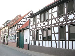
Half-timbered houses in the old village center

The old City Hall


Regular events
The Kisseltag from August 1st 1702 is commemorated annually with a church service . A violent storm with heavy hail devastated the fields, the vineyards and fruit trees in the Umstädter Land and led to great hardship in the small community, which at that time was largely dependent on agriculture .
For over two decades, the football department has been organizing a football tournament for everyone at Whitsun. Two weeks before the Umstädter Winzerfest weekend , the curb with parade, celebration and curb burning takes place and annually on the Wednesday before the Winzerfest the popular run , the Umstädter Winzerfestlauf "Rund um den Stachelberg" is organized.
Economy and Infrastructure
traffic
Klein-Umstadt is located with the Groß-Umstadt Klein-Umstadt stop on the Odenwald Railway from Eberbach am Neckar to Hanau . The district is crossed by four state roads and has bus connections between Groß-Umstadt and Schaafheim. For Winzerfest Gross-Umstadt there is a special bus.
Public facilities
The place has a Protestant kindergarten ("Kinderinsel") with school childcare and the Wendelinus primary school for the districts of Klein-Umstadt and Kleestadt. The school is supported by a joint sponsorship association , whose offerings also allow older children from both places to participate.
Klein-Umstadt has a community center as a club and cultural center and even restored historic old town hall by the citizens of the town. In the village itself several clubs as the cultural initiative are KIKU , sports and shooting clubs (in TSV 1909 Klein-Umstadt is more than one in three citizens of the town members), the theater club hobby little room , the working group village renewal AKDE part of Local Agenda 21 , a notch club and not to forget a volunteer fire brigade with music train active.
An evangelical rectory ( dean's office with Dorndiel) and the evangelical free church Ecclesia are active here in pastoral care. In today's Protestant fortified church, Catholic services are also held.
The UNESCO Geopark educational trail


Between Groß-Umstadt and Klein-Umstadt, the northern Odenwald slopes down into the wide sub-Main plain. Since the Middle Ages , wines have thrived on mineral-rich porphyry and loess soils , especially on the slopes facing south . From the vineyards at the Wendelinus Chapel above Klein-Umstadt, the mountain ranges of Hunsrück , Taunus , Vogelsberg and Spessart as well as the silhouette of " Mainhattan " (Frankfurt am Main) can be seen when the weather is clear . The Lower Main Plain gradually merges into the Reinheimer Hügelland and the hilly Vorderen Odenwald towards the south . Protected from cold easterly winds by the mountain ranges of the northern Odenwald, the area around Klein-Umstadt has climatic similarities to the Bergstrasse .
The educational trail "The Little Mountain Road - Landscape, People and Environment in Klein-Umstadt" in the Geo-Nature Park Bergstraße-Odenwald offers eleven main topics (with information boards) - from the starting point at the train station with background information on the temporal and geological development of the area (1), the Geological structure of the region, with three stones from different geological ages (2) you can touch, the explanation of the regional viticulture on the Stachelberg along the southern edge of the village (3), the viewpoint of the Wendelinus chapel to the surrounding terrain of the region and a circular board (4) and a soil profile , which makes the different usage times of the vineyard, arable land and again the vineyard tangible and explains (5). The story of the place follows: the fire of 1859 (6), the fortified church and its building history from Romanesque to Gothic (7) with remains of the medieval defensive wall, the old town center and the former lower gate (8). The further way leads to the small-Umstädter orchards - originated on abandoned vineyards after the Thirty Years War and several waves of plague and still characterizing the northern edge of the village today (9), up to the barite - mining on site (1839-1931) and the history of the Barite War (10). An additional geopoint ("Breitwieser Bruch") explains the extraction of drinking water from groundwater via deep wells (GP), which is pumped through several layers of brown coal , which fortunately were not powerful enough for profitable extraction . Those who wish can admire the remains of Klein-Umstadt's menhir ( monolith of Klein-Umstadt ) behind the water station .
Wind farm


A wind farm consisting of four wind turbines is located on Binselberg, which is part of the Klein-Umstadt district . In 1999, two 97 meter high Fuhrländer FL 1000 wind turbines with a nominal output of 1 MW each were put into operation, which together generate around 2.9 million kWh of electricity in an average wind year . At the turn of the year 2010/2011, these two systems were supplemented by two 2 MW Enercon E-82 systems. These two newer wind turbines, which have a hub height of 138 meters and a rotor diameter of 82 meters to the rotor tip, are 179 meters high, are operated by the HSE and generate around 9 million kWh of electrical energy per year, corresponding to the electricity consumption of 3000 households.
Personalities
- Johann Heinrich Knöll (1806-1891) was district chairman of the 10th Vienna district of Favoriten .
literature
- Jakob Müller: Homeland book of the community Klein-Umstadt. Verlag LC Wittich, Darmstadt 1956, 108 pages.
- Manfred Schopp, Magistrate of the City of Groß-Umstadt (Hrsg.): Klein-Umstadt in the story 1305-2005. Self-published, 2005, 471 pages.
- Werner Schröder (Ed.): City of Reinheim, the gateway to the Gersprenztal. Self-published by the city of Reinheim / Odw., 1950, 97 pages.
- Baden-Württemberg State Archive : Wertheim State Archive with over 7500 entries, various documents and archive materials on the site.
- Hessian State Archives: Online in Arcinsys Hessen - the archive information system of the Hessian State Archives and other Hessian archives with over 1530 documents and archive materials on the location.
- Literature about Klein-Umstadt in the Hessian Bibliography
Web links
- Districts. In: Internet presence. City of Groß-Umstadt
- Klein-Umstadt. Local history, information. In: www.klein-umstadt.de. Local Advisory Board Klein-Umstadt
- Klein-Umstadt, Darmstadt-Dieburg district. Historical local dictionary for Hessen. (As of July 15, 2014). In: Landesgeschichtliches Informationssystem Hessen (LAGIS).
- The Kleine Bergstrasse - landscape, people and the environment in Klein-Umstadt (PDF file; 1.3 MB)
References and comments
- ↑ a b c d e f Klein-Umstadt, Darmstadt-Dieburg district. Historical local dictionary for Hessen. (As of April 17, 2018). In: Landesgeschichtliches Informationssystem Hessen (LAGIS).
- ↑ a b city districts. In: website. City of Groß-Umstadt, accessed November 2017 .
- ^ Rhein-Main-Tiefland. The natural areas of Hesse and their main units. In: Environmental Atlas Hessen. Accessed November 2019 .
- ↑ Geology of the Odenwald. In: Mineralienatlas - Fossilatlas. Accessed November 2019 .
- ^ The Small Mountain Road - Landscape, People and Environment in Klein-Umstadt. (PDF; 653 kB) In: Flyer Geo-National Park Bergstrasse-Odenwald. Accessed November 2019 .
- ↑ Page no longer available , search in web archives: Landscape plan 2001 / Natural spatial conditions of the city of Groß-Umstadt
- ↑ cf. Literature: Manfred Schopp: Klein-Umstadt in the story 1305-2005. Introduction; see. also the reference to the first documentary evidence of the noble family of the Kesselstatt . The incorrect LAGIS entry from 1229 in the local dictionary. Historical local dictionary for Hessen. In: Landesgeschichtliches Informationssystem Hessen (LAGIS). is assigned to Wenigumstadt in the Bachgau . Documented mentions of 1261 (W. Müller: Hessisches Ortnamesbuch. 1937) and 1287 (Wertheim State Archives: Document R-US US 1287) are not finally assigned.
- ↑ Document No. R-US US 1287 August 29th Baden-Württemberg State Archives / Wertheim State Archives, accessed in November 2019 .
- ↑ Document No. R-US US 1377 May 11th Baden-Württemberg State Archives / Wertheim State Archives, accessed in November 2019 .
- ^ Georg Wilhelm Justin Wagner (Grand Ducal Hessian Court Councilor): The desolations in the Grand Duchy of Hesse. Prov. Starkenburg, Hofbuchhandlung von G. Jonghaus, Darmstadt 1862, p. 110. ( Online at google books )
- ^ Landesarchiv Baden-Württemberg / Staatsarchiv Wertheim, certificate no.R-US 1522 September 15
- ↑ Frankfurt biography. First volume, Vol. A-L, W. Kramer, 1996, 481 pages, p. 254.
- ^ Sebastian Scholz: The inscriptions of the city of Darmstadt and the districts of Darmstadt-Dieburg and Gross-Gerau. Vlg. L. Reichert, 1999, 388 pages, p. 114.
- ↑ JS Verlag, JG Gruber (Ed.): General Encyklopadie der Wissenschaften und Künste. First section A – G, section “Gaukes-Gefreiter”, Ed. MHE Meier, Brockhaus, Leipzig 1852, p. 119.
- ^ Regina Schäfer, Historical Commission for Nassau (ed.): The Lords of Eppstein: Exercise of power, administration and possession of a noble family in the late Middle Ages. 2000. p. 379.
- ↑ Dieter Krieger: Hessisches Wappenbuch , Familienwappen, HFW, Volume 1, CA Starke Verlag, Alsbach 1999.
- ↑ Ludwig Baur (Ed.): Archives for Hessian history and antiquity. Volume 8, Darmstadt 1856, p. 43 f. Online at google books
- ↑ Sources on the history of the Jews. Hessisches Staatsarchiv Marburg: 1267–1600, Volume 2, p. 587
- ↑ HStAD Best. P 1 No. 153 : Elias Hofman, Frankfurt, 1581: Map of Babenhausen and the surrounding area with Dieburg, Münster, Eppertshausen, Ober-Roden and Nieder-Roden, Dudenhofen, Altheim, Semd, Groß-Umstadt and Klein-Umstadt , Richen, Hergershausen, Harpertshausen, Kleestadt, Langstadt, Sickenhofen, Schlierbach, Schaafheim, Altdorf, Seligenstadt, Zell, Zellhausen, Stockstadt, Harreshausen, Ostheim, Pflaumheim
- ↑ About the son-in-law Elias Hofmans ( Memento from July 9, 2012 in the web archive archive.today ) In: Website of the city of Kastellaun.
- ↑ HStAD inventory P 1 no. 620 : Map sketch of the border crossing around the Grünheckerhof corridor in the Klein-Umstadt district with views of Groß-Umstadt, Klein-Umstadt and Kleestadt , description page and image in: Archive Information System Hesse (Arcinsys Hesse).
- ^ Archive for Frankfurt's history and art. Issue 59, Frankfurter Verein für Geschichte und Landeskunde, 1985, p. 118.
- ^ Lectures of the Churpfälzisch physical-economic society in Heidelberg . Winter 1788 to 1789, Volume IV, Part II. Neue Hof- und Academische Buchhandlung, Mannheim, p. 141 ( online at google books ).
- ^ A b c Georg Wilhelm Justin Wagner : Statistical-topographical-historical description of the Grand Duchy of Hesse: Province of Starkenburg . tape 1 . Carl Wilhelm Leske, Darmstadt October 1829, OCLC 312528080 , p. 126 ( online at google books ).
- ↑ 40 years of the Wendelinus School - the story. From the commemorative publication for the inauguration ( memento from July 20, 2004 in the Internet Archive ). Ed .: Schul Zweckverband Klein-Umstadt.
- ↑ Hans Taschen: A brief overview of the mining, metallurgy and saltworks in the Grand Duchy of Hesse. Hofbuchhandlung Verlag G. Jonghaus, Darmstadt 1858, p. 63.
- ↑ Annual reports of the Grand Ducal Hessian Chamber of Commerce in Darmstadt. IV. Annual report for 1867 to 1869, Darmstadt 1869, p. 88.
- ^ Hessian State Archives Darmstadt (HStAD); Land registries (mining land registers) ( G 29 H No. 241 , G 29 H No. 245 , G 29 H No. 246 and G 29 I No. 313 ): a) Berggrundbuch Klein-Umstadt, Raibach and Kleestadt vol. I, with alphabetical Ownership register ( term : 1903–1990), b) Berg land register Kleestadt and Klein-Umstadt, Vol. I, with alphabetical register of owners (1904–1989), c) Mining land register Klein-Umstadt, Raibach, Groß-Umstadt, vol. II (1931– 1955)
- ↑ Karl-Heinz Meier barley, Karl Reinhard Hinkel: Hesse. Municipalities and counties after the regional reform. A documentation . Ed .: Hessian Minister of the Interior. Bernecker, Melsungen 1977, DNB 770396321 , OCLC 180532844 , p. 231 .
- ↑ Law on the reorganization of the districts of Darmstadt and Dieburg and the city of Darmstadt (GVBl. II 330–334) of July 26, 1974 . In: The Hessian Minister of the Interior (ed.): Law and Ordinance Gazette for the State of Hesse . 1974 No. 22 , p. 318 , § 14 ( online at the information system of the Hessian state parliament [PDF; 1.5 MB ]).
- ↑ a b main statute. (PDF; 97 kB) §; 5. In: Website. City of Groß-Umstadt, accessed May 2019 .
- ^ Michael Rademacher: German administrative history from the unification of the empire in 1871 to the reunification in 1990. State of Hesse. (Online material for the dissertation, Osnabrück 2006).
- ^ Grand Ducal Central Office for State Statistics (ed.): Contributions to the statistics of the Grand Duchy of Hesse . tape 1 . Großherzoglicher Staatsverlag, Darmstadt 1862, DNB 013163434 , OCLC 894925483 , p. 43 ff . ( Online at google books ).
- ↑ a b List of offices, places, houses, population. (1806) HStAD inventory E 8 A No. 352/4. In: Archive Information System Hessen (Arcinsys Hessen), as of February 6, 1806.
- ^ Sighard Volp (editor): The Umstädter Pestbuch. Vlg. Umstädter Museum and History Association, Druckvlg. Lockay eK Reinheim, 2005, p. 43 - The Great Wave of Plagues from 1634–1636.
- ^ Ph. AF Walther : Alphabetical index of the residential places in the Grand Duchy of Hesse . G. Jonghaus, Darmstadt 1869, OCLC 162355422 , p. 48 ( online at google books ).
- ↑ Selected data on population and households on May 9, 2011 in the Hessian municipalities and parts of the municipality. (PDF; 1.8 MB) In: 2011 Census . Hessian State Statistical Office
- ^ Local Advisory Board Klein-Umstadt. In: website. City of Groß-Umstadt, accessed October 2019 .
- ↑ Magistrat Stadt Groß-Umstadt: Results of the local council election Klein-Umstadt 2016 ( Memento from March 27, 2016 in the Internet Archive )
- ↑ Magistrat Stadt Groß-Umstadt: Results of local elections 2011 ( Memento from February 11, 2013 in the web archive archive.today )
- ↑ Magistrat Stadt Groß-Umstadt: Results of local elections 2006 ( Memento from February 11, 2013 in the web archive archive.today )
- ^ Hessisches Staatsarchiv Darmstadt (HStAD): coat of arms Klein-Umstadt HStAD Best. R 6 C No. 144, drawing after Georg Massoth, 1955
- ↑ Approval of a coat of arms of the municipality of Klein-Umstadt, Darmstadt district of August 31, 1955 . In: The Hessian Minister of the Interior (ed.): State Gazette for the State of Hesse. 1955 no. 38 , p. 954 , point 1006 ( online at the information system of the Hessian state parliament [PDF; 2.9 MB ]).
- ↑ The speech therapy school "Am Amorbach", which has been independent since 2007 and is responsible for the entire east of the Darmstadt-Dieburg district, has moved its headquarters from Klein-Umstadt to Eppertshausen since summer 2011 , where it has moved into its own building, but no longer integrates the children with it other children can act.
- ↑ Binselberg wind farm , accessed on December 25, 2011
- ↑ Binselberg wind farm , HSE website, accessed on December 25, 2011.

Districts: Umstadt (core city) | Dorndiel | Heubach | Kleestadt | Klein-Umstadt | Raibach | Richen | Semd | Wiebelsbach with Frau-Nauses