Malberg (Westerwald)
| coat of arms | Germany map | |
|---|---|---|

|
Coordinates: 50 ° 43 ' N , 7 ° 49' E |
|
| Basic data | ||
| State : | Rhineland-Palatinate | |
| County : | Altenkirchen (Westerwald) | |
| Association municipality : | Betzdorf-Gebhardshain | |
| Height : | 390 m above sea level NHN | |
| Area : | 4.31 km 2 | |
| Residents: | 1009 (Dec. 31, 2019) | |
| Population density : | 234 inhabitants per km 2 | |
| Postal code : | 57629 | |
| Area code : | 02747 | |
| License plate : | AK | |
| Community key : | 07 1 32 066 | |
| Community structure: | 2 districts | |
| Association administration address: | Hellerstraße 2 57518 Betzdorf |
|
| Website : | ||
| Local Mayor : | Albert Hüsch | |
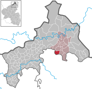
| Location of the local community Malberg in the district of Altenkirchen (Westerwald) | ||
Malberg is a municipality in the Altenkirchen (Westerwald) district in Rhineland-Palatinate . It belongs to the Betzdorf-Gebhardshain community .
Geographical location
Malberg is located in the Westerwald , about 8 km north of Hachenburg and 18 km east of the district town of Altenkirchen . Neighboring communities are Steinebach / Sieg in the north, Rosenheim in the east, Luckenbach in the south and Kundert in the west.
The place consists of the two structurally grown together districts Hommelsberg and Steineberg.
history
The first written mention of the place Steineberg as "Steinthenbergh" is from the year 1366. The place Hommelsberg was mentioned for the first time as "Hummelßbergh" in a Marienstatter document. Hommelsberg is referred to as a single farm in 1579, in 1714 with seven male, adult residents, in 1760 with 42 and 1793 with 37 residents.
The community Malberg was formed on June 7, 1969 from the dissolved and until then independent communities Hommelsberg (523 inhabitants) and Steineberg (336). The new community name was chosen based on a historical court on the Hommelsberg.
- Population development
The development of the population of Malberg in relation to today's municipal area; the values from 1871 to 1987 are based on censuses:
|
|
politics
Municipal council
The council in Malberg consists of twelve council members, who in the local elections on May 26, 2019 in a majority vote were elected, and the honorary mayor as chairman. By the 2019 election, there were 16 council members.
mayor
The local mayor of Malberg is Albert Hüsch. In the direct election on May 26, 2019, he was re-elected with 81.63% of the vote.
coat of arms
|
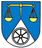
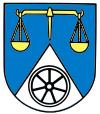
The coat of arms , introduced in 1989, shows golden scales on a blue background. In addition, a half silver point below, inside a black seven-spoke conveyor wheel. |
|
| Justification for the coat of arms: The scales symbolize the eponymous historical court. The conveyor wheels represent the mining industry, which was important in the two districts. The tip symbolizes the final syllable "-berg", which is contained in the names of the earlier communities as well as in the current community name. |
Buildings
The Barbaraturm is a 22 meter high observation tower built in 2014 on the Steineberger Höhe north of Malberg. The tower frame is a former headframe of a disused mine in Bad Grund (Harz) , which dates from the 1930s, was later acquired by committed friends of historical mining and rebuilt in Malberg. The Barbara tower stands directly on the predicate trail Druids riser and provides from its lying at 18 meters viewing platform a good panoramic view.
Personalities
- Peter Weller (1868–1940), photographer and entrepreneur
literature
- Konrad Fuchs: History of the Gebhardshain Association. 1815-1970. Mainz 1982, ISBN 3-87439-082-9 .
- Hellmuth Gensicke : The parish of Kroppach. In: Nassauische Annalen 83. 1972, pp. 209-231.
Web links
- Website of the local community Malberg
- Local community Malberg on the website of the Gebhardshain community
Individual evidence
- ↑ State Statistical Office of Rhineland-Palatinate - population status 2019, districts, communities, association communities ( help on this ).
- ↑ Official municipality directory 2006 ( Memento from December 22, 2017 in the Internet Archive ) (= State Statistical Office Rhineland-Palatinate [Hrsg.]: Statistical volumes . Volume 393 ). Bad Ems March 2006, p. 186 (PDF; 2.6 MB). Info: An up-to-date directory ( 2016 ) is available, but in the section "Territorial changes - Territorial administrative reform" it does not give any population figures.
- ↑ State Statistical Office Rhineland-Palatinate: Regional data.
- ^ The Regional Returning Officer Rhineland-Palatinate: City Council Election 2019 Malberg. Retrieved November 15, 2019 .
- ^ The Regional Returning Officer Rhineland-Palatinate: direct elections 2019. see Betzdorf-Gebhardshain, Verbandsgemeinde, eleventh line of results. Retrieved November 15, 2019 .
- ↑ Barbaraturm on the Steineberger Höhe on vggebhardshain.de


