Corny-sur-Moselle
| Corny-sur-Moselle | ||
|---|---|---|

|
|
|
| region | Grand Est | |
| Department | Moselle | |
| Arrondissement | Metz | |
| Canton | Les Coteaux de Moselle | |
| Community association | Mad et Moselle | |
| Coordinates | 49 ° 2 ′ N , 6 ° 4 ′ E | |
| height | 169-360 m | |
| surface | 8.20 km 2 | |
| Residents | 2,219 (January 1, 2017) | |
| Population density | 271 inhabitants / km 2 | |
| Post Code | 57680 | |
| INSEE code | 57153 | |
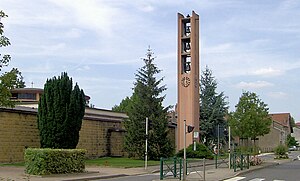
 Bell tower of the Church of St. Martin |
||
Corny-sur-Moselle is a French commune with 2219 inhabitants (as of January 1, 2017) in the Moselle department in the Grand Est region (until 2015 Lorraine ). It belongs to the arrondissement of Metz .
geography
The municipality of Corny-sur-Moselle is located on the steep right bank of the Moselle , about twelve kilometers southwest of Metz . The municipal area covers 8.2 km².
history
The place has been inhabited since prehistoric times.
1915-1918 he carried the Germanized name Corningen and 1940-1944 Korningen . When it was liberated in late 1944, Corny was largely destroyed.
Population development
| year | 1910 | 1962 | 1968 | 1975 | 1982 | 1990 | 1999 | 2007 | 2017 |
| Residents | 792 | 1024 | 1038 | 1132 | 1248 | 1490 | 1759 | 2152 | 2219 |
Culture and sights
- Saint-Martin church on Rue de Metz, built in 1960 in avant-garde style
